รูปภาพหรือไฟล์เสียงนี้ ต้นฉบับอยู่ที่ คอมมอนส์ รายละเอียดด้านล่าง เป็นข้อความที่แสดงผลจาก ไฟล์ต้นฉบับในคอมมอนส์ คอมมอนส์เป็นเว็บไซต์ในโครงการสำหรับเก็บรวบรวมสื่อเสรี ที่ คุณสามารถช่วยได้
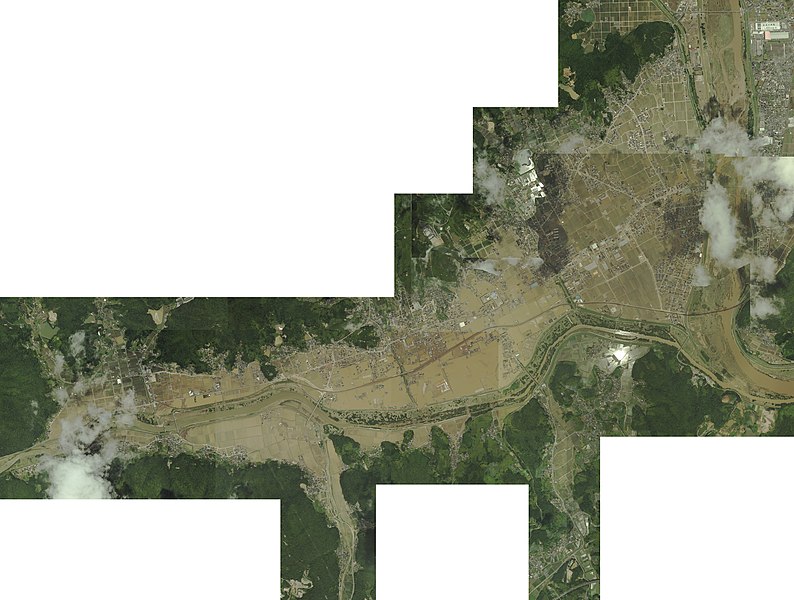
ความย่อ คำอธิบาย平成30年7月豪雨による真備地区の被害.jpg 日本語:
วันที่ 11 กรกฎาคม พ.ศ. 2561 แหล่งที่มา 国土地理院が提供している「高梁川(岡山県倉敷市・総社市)地区(7月9日撮影)」中以下の画像を軽快が合成させた。
コースC11・写真番号52 コースC11・写真番号54 コースC12・写真番号70 コースC12・写真番号72 コースC12・写真番号74 コースC12・写真番号75 コースC12・写真番号76 コースC12・写真番号78 コースC13・写真番号87 コースC13・写真番号89 コースC13・写真番号91 コースC13・写真番号93 コースC13・写真番号95 ผู้สร้างสรรค์ Original Images: Geospatial Information Authority of Japan, composed by 軽快 การอนุญาต(การใช้ไฟล์นี้ใหม่) This work is licensed under the Government of Japan Standard Terms of Use (Ver.2.0). The Terms of Use are compatible with the Creative Commons Attribution License 4.0 International. For terms of use this work, see this license page. English ∙ español ∙ 日本語 ∙ 한국어 ∙ македонски ∙ português ∙ Tiếng Việt ∙ 简体中文 ∙ 繁體中文 ∙ +/−
ไฟล์นี้อยู่ภายใต้สัญญาอนุญาตครีเอทีฟคอมมอนส์ รุ่น แสดงที่มา 4.0 นานาชาติ
การแสดงที่มา: 国土地理院 (Geospatial Information Authority of Japan)
คุณสามารถ: ที่จะแบ่งปัน – ที่จะทำสำเนา แจกจ่าย และส่งงานดังกล่าวต่อไปที่จะเรียบเรียงใหม่ – ที่จะดัดแปลงงานดังกล่าว ภายใต้เงื่อนไขต่อไปนี้: แสดงที่มา – คุณต้องให้เกียรติเจ้าของงานอย่างเหมาะสม โดยเพิ่มลิงก์ไปยังสัญญาอนุญาต และระบุหากมีการเปลี่ยนแปลง คุณอาจทำเช่นนี้ได้ในรูปแบบใดก็ได้ตามควร แต่ต้องไม่ใช่ในลักษณะที่แนะว่าผู้ให้อนุญาตสนับสนุนคุณหรือการใช้งานของคุณ https://creativecommons.org/licenses/by/4.0 CC BY 4.0 Creative Commons Attribution 4.0 true true This file, which was originally posted to 国土地理院が提供している「高梁川(岡山県倉敷市・総社市)地区(7月9日撮影)」中以下の画像を軽快が合成させた。, was reviewed on 9 August 2018 by reviewer Leoboudv , who confirmed that it was available there under the stated license on that date.
ไทย เพิ่มคำบรรยายทรรทัดเดียวเพื่อขยายความว่าไฟล์นี้มีอะไร
ประวัติไฟล์ คลิกวันที่/เวลาเพื่อดูไฟล์ที่ปรากฏในขณะนั้น
วันที่/เวลา รูปย่อ ขนาด ผู้ใช้ ความเห็น ปัจจุบัน 05:54, 11 กรกฎาคม 2561 5,575 × 4,212 (4.71 เมกะไบต์) 軽快 {{Information |Description={{ja|平成30年7月豪雨による真備地区の被害を上空から撮影したもの。}} |Source=国土地理院が提供している「[http://www.gsi.go.jp/BOUSAI/H30.taihuu7gou.html 高梁川(岡山県倉敷市・総社市)地区(7月9日撮影)]」中以下の画像を軽快が合成させた。 * [https://saigai.gsi.go.jp/1/H30_07gouu/takahashigawa/photo/qv/052-qv.jpg コースC11・写真番号52] * [https://saigai.gsi.go.jp/1/H30_07gouu/takahashigawa/photo/qv/054-qv.jpg コースC11・写真番号54] * [https://saigai.gsi.go.jp/1/H30_07gouu/takahashigawa/photo/qv/070-qv.jpg コースC12・写真番号70] * [https://saigai.gsi.go.jp/1/H30_07gouu/takaha...
หน้าที่มีภาพนี้ หน้าต่อไปนี้ โยงมาที่ภาพนี้:
การใช้ไฟล์ส่วนกลาง วิกิอื่นต่อไปนี้ใช้ไฟล์นี้:
ภาพนี้มีข้อมูลเพิ่มเติม ซึ่งส่วนใหญ่มาจากกล้องดิจิตอลหรือสแกนเนอร์ที่สามารถเก็บข้อมูลดังกล่าวไว้รวมกับภาพได้ ถ้าภาพนี้ถูกปรับปรุงแก้ไขหรือเปลี่ยนแปลงจากเดิม ข้อมูลบางอย่างจะยังคงไม่เปลี่ยนแปลงเหมือนภาพที่ถูกปรับปรุงแก้ไขนั้น
ไฟล, 平成30年7月豪雨による真備地区の被害, ไฟล, ประว, ไฟล, หน, าท, ภาพน, การใช, ไฟล, วนกลาง, อม, ลเก, ยวก, บภาพขนาดของต, วอย, างน, กเซล, ความละเอ, ยดอ, กเซล, กเซล, กเซล, กเซล, กเซล, กเซล, ภาพท, ความละเอ, ยดส, งกว, 8206, กเซล, ขนาดไฟล, เมกะไบต, ชน, ดไมม, image, jpeg, ปภาพหร, อไ. ifl prawtiifl hnathimiphaphni karichiflswnklang khxmulekiywkbphaphkhnadkhxngtwxyangni 794 600 phikesl khwamlaexiydxun 318 240 phikesl 635 480 phikesl 1 017 768 phikesl 1 280 967 phikesl 2 560 1 934 phikesl 5 575 4 212 phikesl duphaphthimikhwamlaexiydsungkwa 8206 5 575 4 212 phikesl khnadifl 4 71 emkaibt chnidimm image jpeg rupphaphhruxiflesiyngni tnchbbxyuthi khxmmxns raylaexiyddanlang epnkhxkhwamthiaesdngphlcak ifltnchbbinkhxmmxns khxmmxnsepnewbistinokhrngkarsahrbekbrwbrwmsuxesri thi khunsamarthchwyid khwamyx khaxthibay平成30年7月豪雨による真備地区の被害 jpg 日本語 平成30年7月豪雨による真備地区の被害を上空から撮影したもの wnthi 11 krkdakhm ph s 2561 aehlngthima 国土地理院が提供している 高梁川 岡山県倉敷市 総社市 地区 7月9日撮影 中以下の画像を軽快が合成させた コースC11 写真番号52 コースC11 写真番号54 コースC12 写真番号70 コースC12 写真番号72 コースC12 写真番号74 コースC12 写真番号75 コースC12 写真番号76 コースC12 写真番号78 コースC13 写真番号87 コースC13 写真番号89 コースC13 写真番号91 コースC13 写真番号93 コースC13 写真番号95 phusrangsrrkh Original Images Geospatial Information Authority of Japan composed by 軽快 karxnuyat karichiflniihm This work is licensed under the Government of Japan Standard Terms of Use Ver 2 0 The Terms of Use are compatible with the Creative Commons Attribution License 4 0 International For terms of use this work see this license page English nbsp espanol nbsp 日本語 nbsp 한국어 nbsp makedonski nbsp portugues nbsp Tiếng Việt nbsp 简体中文 nbsp 繁體中文 nbsp iflnixyuphayitsyyaxnuyatkhriexthifkhxmmxns run aesdngthima 4 0 nanachatikaraesdngthima 国土地理院 Geospatial Information Authority of Japan khunsamarth thicaaebngpn thicathasaena aeckcay aelasngngandngklawtxip thicaeriyberiyngihm thicaddaeplngngandngklaw phayitenguxnikhtxipni aesdngthima khuntxngihekiyrtiecakhxngnganxyangehmaasm odyephimlingkipyngsyyaxnuyat aelarabuhakmikarepliynaeplng khunxacthaechnniidinrupaebbidkidtamkhwr aettxngimichinlksnathiaenawaphuihxnuyatsnbsnunkhunhruxkarichngankhxngkhunhttps creativecommons org licenses by 4 0 CC BY 4 0 Creative Commons Attribution 4 0 true true This file which was originally posted to 国土地理院が提供している 高梁川 岡山県倉敷市 総社市 地区 7月9日撮影 中以下の画像を軽快が合成させた was reviewed on 9 August 2018 by reviewer Leoboudv who confirmed that it was available there under the stated license on that date khabrryayodyyxithyephimkhabrryaythrrthdediywephuxkhyaykhwamwaiflnimixairixethmthiaesdngxyuiniflniprakxbdwysthanalikhsiththimilikhsiththisyyaxnuyatCreative Commons Attribution 4 0 International nbsp xngkvswnthisrang wnkxtng11 krkdakhm 2018 prawtiifl khlikwnthi ewlaephuxduiflthipraktinkhnann wnthi ewlarupyxkhnadphuichkhwamehn pccubn05 54 11 krkdakhm 25615 575 4 212 4 71 emkaibt 軽快 Information Description ja 平成30年7月豪雨による真備地区の被害を上空から撮影したもの Source 国土地理院が提供している http www gsi go jp BOUSAI H30 taihuu7gou html 高梁川 岡山県倉敷市 総社市 地区 7月9日撮影 中以下の画像を軽快が合成させた https saigai gsi go jp 1 H30 07gouu takahashigawa photo qv 052 qv jpg コースC11 写真番号52 https saigai gsi go jp 1 H30 07gouu takahashigawa photo qv 054 qv jpg コースC11 写真番号54 https saigai gsi go jp 1 H30 07gouu takahashigawa photo qv 070 qv jpg コースC12 写真番号70 https saigai gsi go jp 1 H30 07gouu takaha hnathimiphaphni hnatxipni oyngmathiphaphni xuthkphyinpraethsyipun ph s 2561 karichiflswnklang wikixuntxipniichiflni karichbn ast wikipedia org Llenes de Xapon de 2018 karichbn en wikipedia org 2018 Japan floods karichbn es wikipedia org Inundaciones de Japon de 2018 karichbn ja wikipedia org 平成30年7月豪雨 karichbn ko wikipedia org 2018년 7월 일본 호우khxmulekiywkbphaph phaphnimikhxmulephimetim sungswnihymacakklxngdicitxlhruxsaeknenxrthisamarthekbkhxmuldngklawiwrwmkbphaphid thaphaphnithukprbprungaekikhhruxepliynaeplngcakedim khxmulbangxyangcayngkhngimepliynaeplngehmuxnphaphthithukprbprungaekikhnnbittxkhxmophennt8khwamsung4 212 phikeslkhwamkwang5 575 phikesl ekhathungcak https th wikipedia org wiki ifl 平成30年7月豪雨による真備地区の被害 jpg, wikipedia, วิกิ หนังสือ, หนังสือ, ห้องสมุด,
บทความ , อ่าน, ดาวน์โหลด, ฟรี, ดาวน์โหลดฟรี, mp3, วิดีโอ, mp4, 3gp, jpg, jpeg, gif, png, รูปภาพ, เพลง, เพลง, หนัง, หนังสือ, เกม, เกม