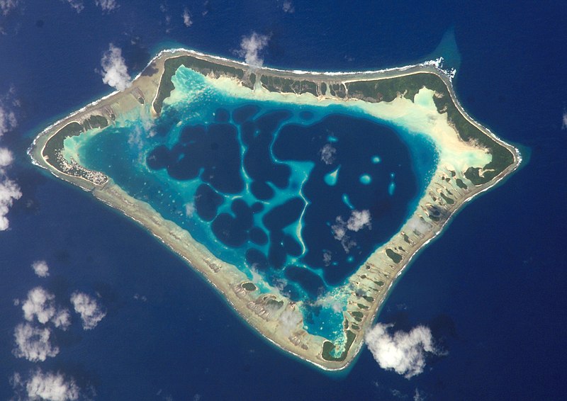
{{Information |Description=Cropped version of Atafu.jpg *{{en|Satellite picture of the Atafu atoll in Tokelau.}} *{{es|Imágen de satélite de Atafu.}} *{{de|Satellitenbild des Atafu Atolls in Tokelau.}} |Source=*File:Atafu.jpg |Dat
ไฟล, atafutrim, ไฟล, ประว, ไฟล, หน, าท, ภาพน, การใช, ไฟล, วนกลาง, อม, ลเก, ยวก, บภาพขนาดของต, วอย, างน, กเซล, ความละเอ, ยดอ, กเซล, กเซล, กเซล, กเซล, กเซล, ภาพท, ความละเอ, ยดส, งกว, 8206, กเซล, ขนาดไฟล, เมกะไบต, ชน, ดไมม, image, jpeg, ปภาพหร, อไฟล, เส, ยงน, นฉบ. ifl prawtiifl hnathimiphaphni karichiflswnklang khxmulekiywkbphaphkhnadkhxngtwxyangni 800 566 phikesl khwamlaexiydxun 320 226 phikesl 640 452 phikesl 1 024 724 phikesl 1 280 905 phikesl 2 088 1 476 phikesl duphaphthimikhwamlaexiydsungkwa 8206 2 088 1 476 phikesl khnadifl 1 16 emkaibt chnidimm image jpeg rupphaphhruxiflesiyngni tnchbbxyuthi khxmmxns raylaexiyddanlang epnkhxkhwamthiaesdngphlcak ifltnchbbinkhxmmxns khxmmxnsepnewbistinokhrngkarsahrbekbrwbrwmsuxesri thi khunsamarthchwyid khaxthibayAtafutrim jpg Cropped version of Atafu jpg English Satellite picture of the Atafu atoll in Tokelau Espanol Imagen de satelite de Atafu Deutsch Satellitenbild des Atafu Atolls in Tokelau wnthi 2 minakhm ph s 2552 00 11 UTC aehlngthima Atafu jpg phusrangsrrkh Atafu jpg NASA Johnson Space Center derivative work Talkstosocks talk taaehnngkhxngwtthuhruxsthanthi8 nbsp 33 nbsp 06 nbsp it 172 nbsp 30 nbsp 03 nbsp tawntk nbsp phaphniaelaphaphxun n sthanthiediywknthi OpenStreetMap 8 551667 172 500833 Public domain Public domain false false phaphniepnsatharnsmbti enuxngcakepnphaphthisrangkhunodyxngkhkarbriharkarbinaelaxwkasaehngchati NASA sungtamnoybaydanlikhsiththikhxngnasarabuiwwa phaphaelasuxtang khxngnasaimidrbkarkhumkhrxngodylikhsiththiykewncarabuiwwamilikhsiththi duephimthi hnanoybaydanlikhsiththikhxngnasa hrux noybaykarichphaphkhxng JPL khaetuxn karich olokkhxngnasa ekhruxnghmayaelaekhruxngpradbkhxngnasa thukcakddwykdhmayshrthxemrikainlksna 14 khxngkhxbngkhbthangrachkarshrthxemrika swnthi 1221 ewbistkhxngnasaekbrwbrwmphaphthimacakxngkhkarxwkasosewiyt xngkhkarxwkasaehngchatirsesiy aelaxngkhkarxwkasthimiichxngkhkarxwkaskhxngshrthxemrika epncanwnmak phaphehlaniimcaepntxngepnsatharnsmbtiesmxip phaphhruxsuxthimacak klxngothrthrrsnxwkashbebil xacmilikhsiththi hakphaphhruxsuxnnimidrabuchdecnwamacak sthabnwithyasastrklxngothrthrrsnxwkas 1 phaphhruxsuxthnghmdthimacakekhruxngmuxkhxng okhrngkarsuksadwngxathityaelalmsuriya milikhsiththi karnaphaphhruxsuxcakokhrngkaripichnxkehnuxcakkarichephuxkarkhahruxephuxkarsuksa txngidrbxnuyatkxn 2 phaphthithukkhdeluxkihepn phaphdarasastrpracawn APOD bnewbistkhxng APOD xacmilikhsiththi 3 bnthukkarxphohld This image is a derivative work of the following images File Atafu jpg licensed with PD USGov NASA 2008 04 05T21 22 08Z Gugganij 3032x2064 1008353 Bytes 2006 09 29T21 11 16Z AxeEffect 639x435 47391 Bytes Atafu Tokelau Islands Uploaded with derivativeFX phaphxnthrngkhunkhaphaphniidrbkarpraeminphayit eknthphaphxnthrngkhunkha aelathuxwaepn phaphxnthrngkhunkhathisudinkhxmmxns phayitkhxbekht Atafu atoll Tokelau satellite view khunsamarthdukaresnxchuxid thini khabrryayodyyxithyephimkhabrryaythrrthdediywephuxkhyaykhwamwaiflnimixairxngkvsSatellite image of the Atafu Atoll in Tokelau eyxrmnSatellitenbild des Atafu Atolls in Tokelau xitaliImmagine satellitare dell atollo di Atafu a Tokelau frngessImage satellite de l atoll Atafu a Tokelau ixethmthiaesdngxyuiniflniprakxbdwyMIME type nbsp xngkvsimage jpegCommons quality assessment nbsp xngkvsWikimedia Commons valued image nbsp xngkvsewlaerim 25 singhakhm 2022checksum nbsp xngkvs8e5b99f561da5beba4d893ce45434c7031af4bfewithikarkahnd SHA 1 nbsp xngkvsdata size nbsp xngkvs1 216 870 ibtkhwamsung1 476 phikeslkhwamkwang2 088 phikeslcoordinates of depicted place nbsp xngkvs8 33 6 001 S 172 30 2 999 W prawtiifl khlikwnthi ewlaephuxduiflthipraktinkhnann wnthi ewlarupyxkhnadphuichkhwamehn pccubn07 12 2 minakhm 25522 088 1 476 1 16 emkaibt Talkstosocks Information Description Cropped version of Atafu jpg en Satellite picture of the Atafu atoll in Tokelau es Imagen de satelite de Atafu de Satellitenbild des Atafu Atolls in Tokelau Source File Atafu jpg Dat hnathimiphaphni hnatxipni oyngmathiphaphni xathxll sthaniyxy phumisastr karichiflswnklang wikixuntxipniichiflni karichbn ace wikipedia org Pulo karichbn als wikipedia org Portal Geografi Portal Geografi Kopf Atoll karichbn ar wikipedia org علم شكل الأرض المناخي karichbn bar wikipedia org Atoll karichbn bh wikipedia org एट ल karichbn bn wikipedia org উপহ রদ karichbn bs wikipedia org Atafu karichbn cs wikipedia org Laguna Laguna rozcestnik karichbn de wikipedia org Atoll Korallenriff Atafu karichbn el wiktionary org atolh karichbn en wikipedia org Lagoon Outline of Tokelau Climatic geomorphology Darwin Guyot karichbn en wikiversity org Draft Original research Geomorphology karichbn en wiktionary org atoll atollo karichbn es wikipedia org Atolon karichbn es wikibooks org Curso de aleman para principiantes con audio Leccion 120 karichbn eu wikipedia org Atoloi karichbn fa wikipedia org جزیره karichbn fr wikipedia org Geomorphologie Insularite Utilisateur Skimel illustration des iles du Pacifique karichbn ga wikipedia org Atall karichbn he wikipedia org פולינזיה אטול karichbn hi wikipedia org प रव लद व प karichbn ia wikipedia org Atollo karichbn id wiktionary org Wiktionary ProyekWiki bahasa Indonesia Daftar kata Nama Bentang alam karichbn is wikipedia org Hringrif karichbn kbd wikipedia org Atoll karichbn km wikipedia org អ ត ល karichbn ko wikipedia org 환초 karichbn ku wiktionary org atol karichbn la wikipedia org Disputatio Lacuna mare karichbn lv wikipedia org Atols karichbn mdf wikipedia org Atolls karichbn mk wikipedia org Atol karichbn ml wikipedia org ദ വ പ അട ല കൾ karichbn ms wikipedia org Atol Wikipedia Tahukah anda Arkib 2010 Lagun Atafu dukarichthwolkephimetimkhxngiflnikhxmulekiywkbphaph phaphnimikhxmulephimetim sungswnihymacakklxngdicitxlhruxsaeknenxrthisamarthekbkhxmuldngklawiwrwmkbphaphid thaphaphnithukprbprungaekikhhruxepliynaeplngcakedim khxmulbangxyangcayngkhngimepliynaeplngehmuxnphaphthithukprbprungaekikhnn error0 ekhathungcak https th wikipedia org wiki ifl Atafutrim jpg, wikipedia, วิกิ หนังสือ, หนังสือ, ห้องสมุด,