I used Image:India-locator-map-blank.svg as base and edited myself using inkspace and created it by looking at the following source.
Suryanath U. Kamat, A Concise history of Karnataka from pre-historic times to the present, Jupiter books, MCC, Bangalore, 2001 (Reprinted 2002) OCLC: 7796041 p327
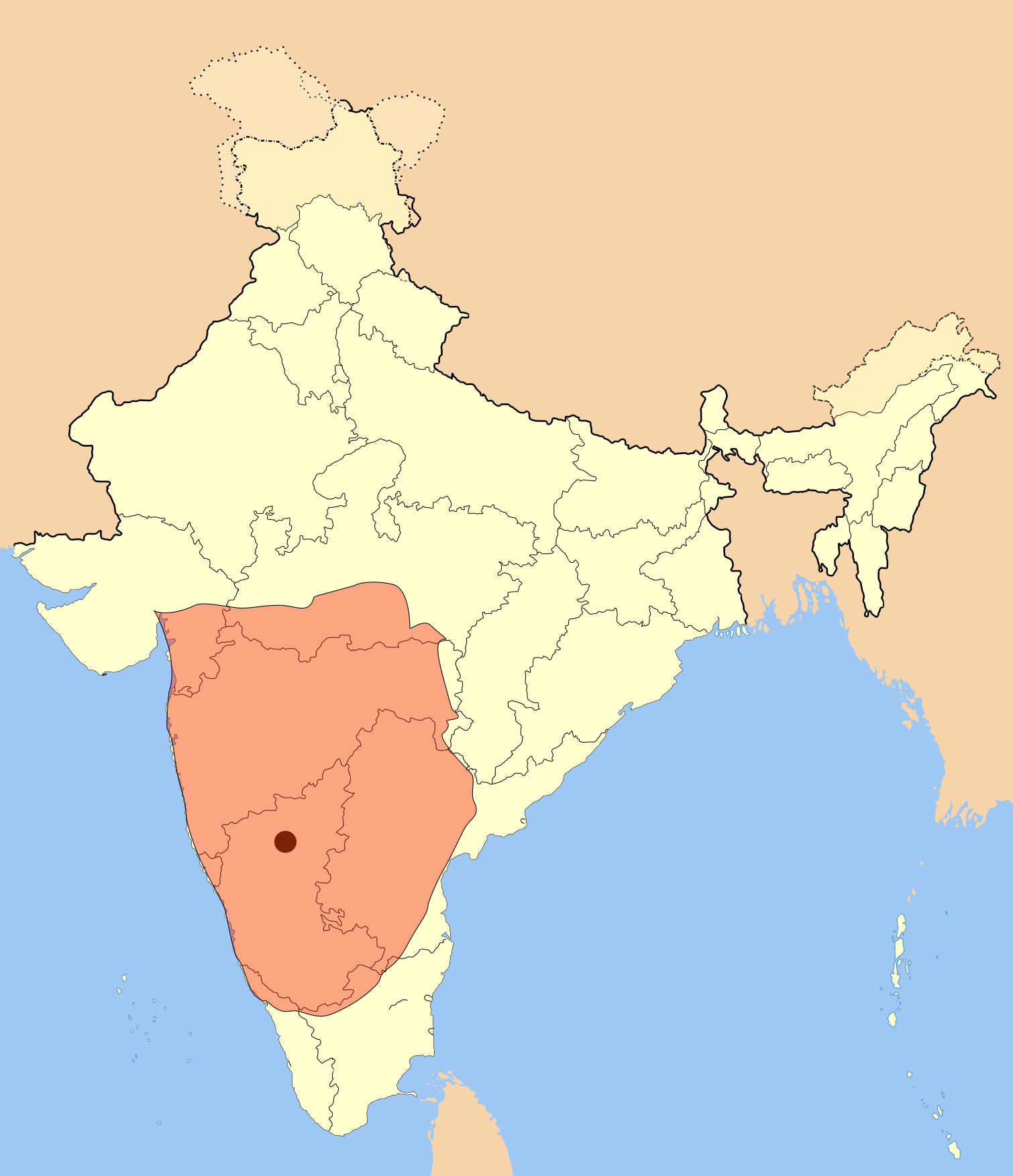
A province of this empire comprising of Andhra region became the "Eastern Chalukyas" in the years following the death of Pulakesi II.
Note: Original source has overlay of Kadamba, Rastrakuta and Western Ganga kingdom maps on the same page, I placed only the Badami Chalukya empire map.
I used Image:India-locator-map-blank.svg as base and edited myself using inkspace and created it by looking at the following source. Suryanath U. Kamat, A Concise history of Karnataka from pre-historic times to the present, Jupiter books, MCC, Bangalore
== Summary == I used Image:India-locator-map-blank.svg as base and edited myself using inkspace and created it by looking at the following source. Suryanath U. Kamat, A Concise history of Karnataka from pre-historic times to the present, Jupiter books,
ไฟล, badami, chalukya, empire, ไฟล, ประว, ไฟล, หน, าท, ภาพน, การใช, ไฟล, วนกลาง, อม, ลเก, ยวก, บภาพขนาดของต, วอย, าง, ของไฟล, กเซล, ความละเอ, ยดอ, กเซล, กเซล, กเซล, กเซล, กเซล, กเซล, ภาพท, ความละเอ, ยดส, งกว, 8206, ไฟล, กเซล, ขนาดไฟล, โลไบต, ปภาพหร, อไฟล, เส, . ifl prawtiifl hnathimiphaphni karichiflswnklang khxmulekiywkbphaphkhnadkhxngtwxyang PNG nikhxngifl SVG ni 516 599 phikesl khwamlaexiydxun 207 240 phikesl 413 480 phikesl 661 768 phikesl 882 1 024 phikesl 1 764 2 048 phikesl 1 510 1 753 phikesl duphaphthimikhwamlaexiydsungkwa 8206 ifl SVG 1 510 1 753 phikesl khnadifl 339 kiolibt rupphaphhruxiflesiyngni tnchbbxyuthi khxmmxns raylaexiyddanlang epnkhxkhwamthiaesdngphlcak ifltnchbbinkhxmmxns khxmmxnsepnewbistinokhrngkarsahrbekbrwbrwmsuxesri thi khunsamarthchwyid khwamyx I used Image India locator map blank svg as base and edited myself using inkspace and created it by looking at the following source Suryanath U Kamat A Concise history of Karnataka from pre historic times to the present Jupiter books MCC Bangalore 2001 Reprinted 2002 OCLC 7796041 p327A province of this empire comprising of Andhra region became the Eastern Chalukyas in the years following the death of Pulakesi II Note Original source has overlay of Kadamba Rastrakuta and Western Ganga kingdom maps on the same page I placed only the Badami Chalukya empire map khaxthibayBadami chalukya empire map svg Badami Chalukya Empire Map wnthi 26 phvsphakhm ph s 2550 aehlngthima ngankhxngtw phusrangsrrkh Mlpkr karxnuyatichsiththi khapheca inthanaphuthuxlikhsiththikhxngphaphhruxsuxni xnuyatihichphaphhruxsuxniphayitenguxnikhtxipni xnuyatihkhdlxk aeckcayaela hruxddaeprexksarniphayitenguxnikhkhxngsyyaxnuyatexksaresrikhxngknu run 1 2 hruxrunid nbcaknithixxkodymulnithisxftaewresri odyimmiswnidhamaekikh immikhxkhwampkhnaaelapkhlng saenakhxngsyyaxnuyatrwmxyuinswnchux syyaxnuyatexksaresrikhxngknuhttp www gnu org copyleft fdl html GFDL GNU Free Documentation License true true iflnixyuphayitsyyaxnuyat khriexthifkhxmmxns aebbaesdngthima xnuyataebbediywkn 3 0 tnchbb khunsamarth thicaaebngpn thicathasaena aeckcay aelasngngandngklawtxip thicaeriyberiyngihm thicaddaeplngngandngklaw phayitenguxnikhtxipni aesdngthima khuntxngihekiyrtiecakhxngnganxyangehmaasm odyephimlingkipyngsyyaxnuyat aelarabuhakmikarepliynaeplng khunxacthaechnniidinrupaebbidkidtamkhwr aettxngimichinlksnathiaenawaphuihxnuyatsnbsnunkhunhruxkarichngankhxngkhun xnuyataebbediywkn hakkhunddaeplng epliynrup hruxtxetimnganni khuntxngichsyyaxnuyataebbediywknhruxaebbthiehmuxnkbsyyaxnuyatthiichkbnganniethann payaesdngsthanalikhsiththinithukephimephuxihepniptamkarepliynaeplngsyyaxnuyatkhxngmulnithiwikimiediy cak GFDL ipyng GFDL khwbkhukb CC BY SA 3 0 http creativecommons org licenses by sa 3 0 CC BY SA 3 0 Creative Commons Attribution Share Alike 3 0 true trueiflnixyuphayitsyyaxnuyatkhriexthifkhxmmxns runaesdngthima xnuyataebbediywkn 2 5 thwip 2 0 thwip aela 1 0 thwipkhunsamarth thicaaebngpn thicathasaena aeckcay aelasngngandngklawtxip thicaeriyberiyngihm thicaddaeplngngandngklaw phayitenguxnikhtxipni aesdngthima khuntxngihekiyrtiecakhxngnganxyangehmaasm odyephimlingkipyngsyyaxnuyat aelarabuhakmikarepliynaeplng khunxacthaechnniidinrupaebbidkidtamkhwr aettxngimichinlksnathiaenawaphuihxnuyatsnbsnunkhunhruxkarichngankhxngkhun xnuyataebbediywkn hakkhunddaeplng epliynrup hruxtxetimnganni khuntxngichsyyaxnuyataebbediywknhruxaebbthiehmuxnkbsyyaxnuyatthiichkbnganniethannhttps creativecommons org licenses by sa 2 5 CC BY SA 2 5 Creative Commons Attribution Share Alike 2 5 true truekhunsamartheluxksyyaxnuyatdngklawtamtxngkarkhabrryayodyyxithyephimkhabrryaythrrthdediywephuxkhyaykhwamwaiflnimixairxngkvsChalukya Territories during Pulakeshi II c 640 C E ixethmthiaesdngxyuiniflniprakxbdwyphusrangbangkhathiimmiixethmwikisnethschuxphuichwikimiediy Mlpkryuxaraexl https commons wikimedia org wiki user Mlpkrchuxphusrangsrrkh MlpkrsthanalikhsiththimilikhsiththisyyaxnuyatCreative Commons Attribution ShareAlike 3 0 Unported nbsp xngkvsCreative Commons Attribution ShareAlike 1 0 Generic nbsp xngkvsCreative Commons Attribution ShareAlike 2 0 Generic nbsp xngkvsGNU Free Documentation License version 1 2 or later nbsp xngkvsCreative Commons Attribution ShareAlike 2 5 Generic nbsp xngkvsthimakhxngiflkarsrangdngedimodyphuxpohldwnthisrang wnkxtng26 phvsphakhm 2007 prawtiifl khlikwnthi ewlaephuxduiflthipraktinkhnann wnthi ewlarupyxkhnadphuichkhwamehn pccubn07 28 19 krkdakhm 25601 510 1 753 339 kiolibt Renato de Carvalho FerreiraAjustes gerais 05 49 28 phvsphakhm 25501 651 1 753 432 kiolibt MlpkrI used Image India locator map blank svg as base and edited myself using inkspace and created it by looking at the following source Suryanath U Kamat A Concise history of Karnataka from pre historic times to the present Jupiter books MCC Bangalore 06 09 27 phvsphakhm 25501 651 1 753 432 kiolibt Mlpkr Summary I used Image India locator map blank svg as base and edited myself using inkspace and created it by looking at the following source Suryanath U Kamat A Concise history of Karnataka from pre historic times to the present Jupiter books 05 25 27 phvsphakhm 25501 651 1 753 431 kiolibt Mlpkr Information Description Source self made Date Author User Mlpkr hnathimiphaphni hnatxipni oyngmathiphaphni rachwngscalukya karichiflswnklang wikixuntxipniichiflni karichbn ar wikipedia org سلالة تشالوكيا الحاكمة karichbn ba wikipedia org In ҙur dәүlәttәr isemlege karichbn bn wikipedia org ভ রত র ইত হ স চ ল ক য স ম র জ য karichbn ca wikipedia org Badami Txalukia Txalukies de Vatapi karichbn da wikipedia org Indien karichbn en wikipedia org 543 Kadamba dynasty Badami Aihole Rashtrakuta dynasty Pulakeshin II Vakataka dynasty Eastern Chalukyas North Karnataka Political history of medieval Karnataka Wikipedia Today s featured article July 9 2010 Wikipedia Today s featured article July 2010 Chalukya dynasty Pushyabhuti dynasty Kalachuri dynasty Chalukyas of Navasarika karichbn es wikipedia org Historia de la India Anexo Imperios por superficie karichbn fi wikipedia org Chalukya karichbn fr wikipedia org Chalukya karichbn gu wikipedia org ભ રતન ઇત હ સ બદ મ કર ણ ટક karichbn hi wikipedia org च ल क य र जव श ब द म कर न टक कर न टक क इत ह स karichbn hu wikipedia org Csalukja dinasztia India uralkodoinak listaja karichbn hy wikipedia org Աշխարհի պատմության խոշորագույն տերությունների կայսրությունների ցանկ karichbn id wikipedia org Dinasti Chalukya karichbn it wikipedia org Chalukya karichbn ja wikipedia org 前期チャールキヤ朝 帝国の最大領域一覧 karichbn ka wikipedia org ინდოეთი karichbn kn wikipedia org ಇಮ ಮಡ ಪ ಲಕ ಶ ಕದ ಬ ಮನ ತನ karichbn ko wikipedia org 라슈트라쿠타 찰루키아 karichbn lt wikipedia org Calukju dinastija karichbn meta wikimedia org User Mallikarjunasj karichbn ml wikipedia org ച ല ക യ ര ജവ ശ ഇന ത യ ചര ത ര പ ലക ശ I dukarichthwolkephimetimkhxngiflnikhxmulekiywkbphaph phaphnimikhxmulephimetim sungswnihymacakklxngdicitxlhruxsaeknenxrthisamarthekbkhxmuldngklawiwrwmkbphaphid thaphaphnithukprbprungaekikhhruxepliynaeplngcakedim khxmulbangxyangcayngkhngimepliynaeplngehmuxnphaphthithukprbprungaekikhnnkhwamkwang1510khwamsung1752 6666 ekhathungcak https th wikipedia org wiki ifl Badami chalukya empire map svg, wikipedia, วิกิ หนังสือ, หนังสือ, ห้องสมุด,