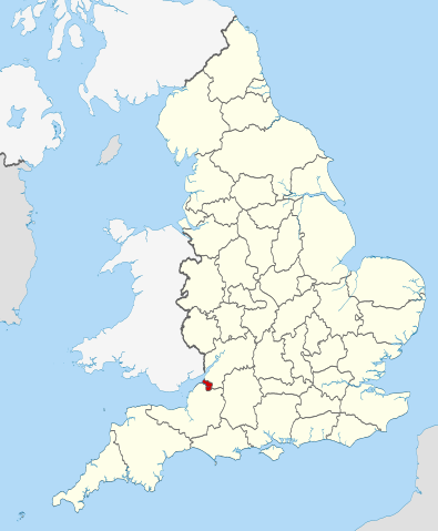
This is one of the images forming part of the Valued image set: Locator maps of the Ceremonial counties of England on Wikimedia Commons. The image set has been assessed under the valued image set criteria and is considered the most valued set on Commons within the scope:
Locator maps of the Ceremonial counties of England
You can see its nomination at Commons:Valued image candidates/Locator maps of English ceremonial counties.
== Summary == {{Information |Description=Location of the ceremonial county of Bristol within England. |Source=Ordnance Survey [https://www.ordnancesurvey.co.uk/opendatadownload/products.html OpenData]: *County boundarie
ไฟล, bristol, locator, 2010, ไฟล, ประว, ไฟล, หน, าท, ภาพน, การใช, ไฟล, วนกลางขนาดของต, วอย, าง, ของไฟล, กเซล, ความละเอ, ยดอ, กเซล, กเซล, กเซล, กเซล, กเซล, กเซล, ภาพท, ความละเอ, ยดส, งกว, 8206, ไฟล, กเซล, ขนาดไฟล, โลไบต, ปภาพหร, อไฟล, เส, ยงน, นฉบ, บอย, คอมมอนส. ifl prawtiifl hnathimiphaphni karichiflswnklangkhnadkhxngtwxyang PNG nikhxngifl SVG ni 494 600 phikesl khwamlaexiydxun 198 240 phikesl 395 480 phikesl 633 768 phikesl 843 1 024 phikesl 1 687 2 048 phikesl 1 108 1 345 phikesl duphaphthimikhwamlaexiydsungkwa 8206 ifl SVG 1 108 1 345 phikesl khnadifl 302 kiolibt rupphaphhruxiflesiyngni tnchbbxyuthi khxmmxns raylaexiyddanlang epnkhxkhwamthiaesdngphlcak ifltnchbbinkhxmmxns khxmmxnsepnewbistinokhrngkarsahrbekbrwbrwmsuxesri thi khunsamarthchwyid khwamyx khaxthibayBristol UK locator map 2010 svg Location of the ceremonial county of Bristol within England wnthi 16 phvscikayn ph s 2553aehlngthima Ordnance Survey OpenData County boundaries and GB coastlineNational Geospatial Intelligence Agency Irish French and Isle of Man coastlines Lough Neagh and Irish borderphusrangsrrkh Nilfanion karxnuyatichsiththi khapheca inthanaphuthuxlikhsiththikhxngphaphhruxsuxni xnuyatihichphaphhruxsuxniphayitenguxnikhtxipniiflnixyuphayitsyyaxnuyat khriexthifkhxmmxns aebbaesdngthima xnuyataebbediywkn 3 0 tnchbbkhunsamarth thicaaebngpn thicathasaena aeckcay aelasngngandngklawtxip thicaeriyberiyngihm thicaddaeplngngandngklaw phayitenguxnikhtxipni aesdngthima khuntxngihekiyrtiecakhxngnganxyangehmaasm odyephimlingkipyngsyyaxnuyat aelarabuhakmikarepliynaeplng khunxacthaechnniidinrupaebbidkidtamkhwr aettxngimichinlksnathiaenawaphuihxnuyatsnbsnunkhunhruxkarichngankhxngkhun xnuyataebbediywkn hakkhunddaeplng epliynrup hruxtxetimnganni khuntxngichsyyaxnuyataebbediywknhruxaebbthiehmuxnkbsyyaxnuyatthiichkbnganniethannhttps creativecommons org licenses by sa 3 0 CC BY SA 3 0 Creative Commons Attribution Share Alike 3 0 true true xnuyatihkhdlxk aeckcayaela hruxddaeprexksarniphayitenguxnikhkhxngsyyaxnuyatexksaresrikhxngknu run 1 2 hruxrunid nbcaknithixxkodymulnithisxftaewresri odyimmiswnidhamaekikh immikhxkhwampkhnaaelapkhlng saenakhxngsyyaxnuyatrwmxyuinswnchux syyaxnuyatexksaresrikhxngknuhttp www gnu org copyleft fdl html GFDL GNU Free Documentation License true truekhunsamartheluxksyyaxnuyatdngklawtamtxngkar This is one of the images forming part of the Valued image set Locator maps of the Ceremonial counties of England on Wikimedia Commons The image set has been assessed under the valued image set criteria and is considered the most valued set on Commons within the scope Locator maps of the Ceremonial counties of England You can see its nomination at Commons Valued image candidates Locator maps of English ceremonial counties khabrryayodyyxithyephimkhabrryaythrrthdediywephuxkhyaykhwamwaiflnimixairixethmthiaesdngxyuiniflniprakxbdwyphusrangbangkhathiimmiixethmwikisnethschuxphuichwikimiediy Nilfanionyuxaraexl https commons wikimedia org wiki user Nilfanionchuxphusrangsrrkh NilfanionsthanalikhsiththimilikhsiththisyyaxnuyatGNU Free Documentation License version 1 2 or later xngkvsCreative Commons Attribution ShareAlike 3 0 Unported xngkvswnthisrang wnkxtng16 phvscikayn 2010 prawtiifl khlikwnthi ewlaephuxduiflthipraktinkhnann wnthi ewlarupyxkhnadphuichkhwamehn pccubn05 30 24 phvscikayn 25531 108 1 345 302 kiolibt Nilfanion Summary Information Description Location of the ceremonial county of Bristol within England Source Ordnance Survey https www ordnancesurvey co uk opendatadownload products html OpenData County boundarie hnathimiphaphni hnatxipni oyngmathiphaphni bristxl karichiflswnklang wikixuntxipniichiflni karichbn ar wikipedia org برستل karichbn arz wikipedia org بريستول karichbn ast wikipedia org Bristol karichbn bg wikipedia org Yugozapadna Angliya karichbn ca wikipedia org Bristol Llista de comtats cerimonials d Anglaterra karichbn cs wikipedia org Bristol karichbn de wikipedia org Liste der Grade I Baudenkmaler in Bristol karichbn diq wikipedia org Bristol karichbn el wikipedia org Mpristol karichbn en wikipedia org Snuff Mills Knowle Bristol The Chessels Lawrence Weston Bristol Template Bristol geo stub Stoke Lodge Sneyd Park Golden Hill Bristol Monks Park Windmill Hill Bristol Hengrove Speedwell Bristol Westbury Park Bristol Bullock s Park Ashton Vale Hillfields Bristol Kingsdown Bristol Trinity Road Police Station Former Bank of England Bristol Old Post Office Bristol Quakers Friars St Nicholas Almshouses Mauretania Bristol Kings Weston Hill Foster s Almshouses Bristol Merchant Hall Bristol Marina Silicon Gorge Clifton East former ward Whitchurch Park ward Filwood ward St George East Northern Stormwater Interceptor Bristol Ashton Gate Bristol Millennium Square Bristol Great Stoke Begbrook Purdown User Dr Blofeld April 2011 Leigh Woods Somerset dukarichthwolkephimetimkhxngiflni ekhathungcak https th wikipedia org wiki ifl Bristol UK locator map 2010 svg, wikipedia, วิกิ หนังสือ, หนังสือ, ห้องสมุด,