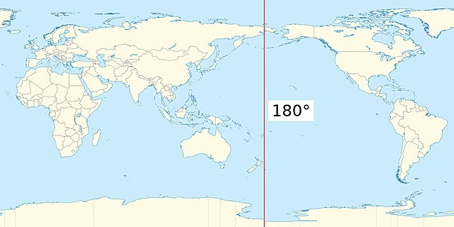
This file is derived from Earthmap1000x500compac.jpg (public domain). I rotated the map to have the cut through the Atlantic ocean, instead of the Pacific, then added the 180th meridian.
ไฟล์นี้มีให้ใช้ภายใต้ CC0 1.0 Universal Public Domain Dedication ของครีเอทีฟคอมมอนส์
The person who associated a work with this deed has dedicated the work to the public domain by waiving all of their rights to the work worldwide under copyright law, including all related and neighboring rights, to the extent allowed by law. You can copy, modify, distribute and perform the work, even for commercial purposes, all without asking permission.
http://creativecommons.org/publicdomain/zero/1.0/deed.enCC0Creative Commons Zero, Public Domain Dedicationfalsefalse
Re-created on the basis of {{F|World location map (equirectangular 180).svg}}, as the previous version was based on a file mislabeled as public domain.
ไฟล, earth, with, 180th, meridian, ไฟล, ประว, ไฟล, หน, าท, ภาพน, การใช, ไฟล, วนกลางขนาดของต, วอย, างน, กเซล, ความละเอ, ยดอ, กเซล, กเซล, กเซล, ภาพท, ความละเอ, ยดส, งกว, 8206, กเซล, ขนาดไฟล, โลไบต, ชน, ดไมม, image, jpeg, ปภาพหร, อไฟล, เส, ยงน, นฉบ, บอย, คอมมอนส,. ifl prawtiifl hnathimiphaphni karichiflswnklangkhnadkhxngtwxyangni 800 400 phikesl khwamlaexiydxun 320 160 phikesl 640 320 phikesl 1 024 512 phikesl duphaphthimikhwamlaexiydsungkwa 8206 1 024 512 phikesl khnadifl 102 kiolibt chnidimm image jpeg rupphaphhruxiflesiyngni tnchbbxyuthi khxmmxns raylaexiyddanlang epnkhxkhwamthiaesdngphlcak ifltnchbbinkhxmmxns khxmmxnsepnewbistinokhrngkarsahrbekbrwbrwmsuxesri thi khunsamarthchwyid khwamyx khaxthibayEarth map with 180th meridian jpg English Earth map centered on the Pacific ocean with the 180th meridian highlighted wnthi 14 tulakhm ph s 2558 aehlngthima ngankhxngtw phusrangsrrkh Edgar Bonet ewxrchnxun Earthmap1000x500compac jpg nbsp File Earthmap1000x500compac jpg This file is derived from Earthmap1000x500compac jpg public domain I rotated the map to have the cut through the Atlantic ocean instead of the Pacific then added the 180th meridian karxnuyatichsiththi khapheca inthanaphuthuxlikhsiththikhxngphaphhruxsuxni xnuyatihichphaphhruxsuxniphayitenguxnikhtxipni nbsp iflnimiihichphayit CC0 1 0 Universal Public Domain Dedication khxngkhriexthifkhxmmxns The person who associated a work with this deed has dedicated the work to the public domain by waiving all of their rights to the work worldwide under copyright law including all related and neighboring rights to the extent allowed by law You can copy modify distribute and perform the work even for commercial purposes all without asking permission http creativecommons org publicdomain zero 1 0 deed en CC0 Creative Commons Zero Public Domain Dedication false falsekhabrryayodyyxithyephimkhabrryaythrrthdediywephuxkhyaykhwamwaiflnimixairxngkvsEarth Map With 180th Meridianxahrbخط الزوال العكسيixethmthiaesdngxyuiniflniprakxbdwyphusrangbangkhathiimmiixethmwikisnethsyuxaraexl https commons wikimedia org wiki user Edgar bonetchuxphusrangsrrkh Edgar Bonetchuxphuichwikimiediy Edgar bonetsthanalikhsiththicopyrighted dedicated to the public domain by copyright holder nbsp xngkvssyyaxnuyatCC0 nbsp xngkvswnthisrang wnkxtng14 tulakhm 2015thimakhxngiflkarsrangdngedimodyphuxpohldMIME type nbsp xngkvsimage jpeg prawtiifl khlikwnthi ewlaephuxduiflthipraktinkhnann wnthi ewlarupyxkhnadphuichkhwamehn pccubn19 35 20 krkdakhm 25631 024 512 102 kiolibt Edgar bonetRe created on the basis of F World location map equirectangular 180 svg as the previous version was based on a file mislabeled as public domain hnathimiphaphni hnatxipni oyngmathiphaphni esnemriediynthi 180 xngsa karichiflswnklang wikixuntxipniichiflni karichbn ar wikipedia org خط الطول العكسي karichbn bn wikipedia org ১৮০ দ র ঘ ম র খ karichbn ca wikipedia org Meridia 180 karichbn el wikipedia org 180os meshmbrinos karichbn en wikipedia org 180th meridian Template talk Location map line karichbn en wiktionary org antimeridian karichbn he wikipedia org קו האורך 180 karichbn hi wikipedia org 180 र ख श karichbn ja wikipedia org 180度経線 karichbn ko wikipedia org 경도 180도 karichbn ms wikipedia org Meridian ke 180 karichbn www wikidata org Q838283 ekhathungcak https th wikipedia org wiki ifl Earth map with 180th meridian jpg, wikipedia, วิกิ หนังสือ, หนังสือ, ห้องสมุด,