รูปภาพหรือไฟล์เสียงนี้ ต้นฉบับอยู่ที่ คอมมอนส์ รายละเอียดด้านล่าง เป็นข้อความที่แสดงผลจาก ไฟล์ต้นฉบับในคอมมอนส์ คอมมอนส์เป็นเว็บไซต์ในโครงการสำหรับเก็บรวบรวมสื่อเสรี ที่ คุณสามารถช่วยได้
คำอธิบายIsaanmountains.svg English:
วันที่ 13 มิถุนายน พ.ศ. 2551 แหล่งที่มา งานของตัว ผู้สร้างสรรค์ Hdamm การอนุญาต(การใช้ไฟล์นี้ใหม่) ข้าพเจ้า ในฐานะผู้ถือลิขสิทธิ์ของภาพหรือสื่อนี้ อนุญาตให้ใช้ภาพหรือสื่อนี้ภายใต้เงื่อนไขต่อไปนี้
อนุญาตให้คัดลอก แจกจ่ายและ/หรือดัดแปรเอกสารนี้ภายใต้เงื่อนไขของสัญญาอนุญาตเอกสารเสรีของกนู รุ่น 1.2 หรือรุ่นใด ๆ นับจากนี้ที่ออกโดยมูลนิธิซอฟต์แวร์เสรี โดยไม่มีส่วนใดห้ามแก้ไข ไม่มีข้อความปกหน้าและปกหลัง สำเนาของสัญญาอนุญาตรวมอยู่ในส่วนชื่อ สัญญาอนุญาตเอกสารเสรีของกนู http://www.gnu.org/copyleft/fdl.html GFDL GNU Free Documentation License true true
This file is licensed under the Creative Commons Attribution-Share Alike 4.0 International, 3.0 Unported, 2.5 Generic, 2.0 Generic and 1.0 Generic license.
คุณสามารถ: ที่จะแบ่งปัน – ที่จะทำสำเนา แจกจ่าย และส่งงานดังกล่าวต่อไปที่จะเรียบเรียงใหม่ – ที่จะดัดแปลงงานดังกล่าว ภายใต้เงื่อนไขต่อไปนี้: แสดงที่มา – คุณต้องให้เกียรติเจ้าของงานอย่างเหมาะสม โดยเพิ่มลิงก์ไปยังสัญญาอนุญาต และระบุหากมีการเปลี่ยนแปลง คุณอาจทำเช่นนี้ได้ในรูปแบบใดก็ได้ตามควร แต่ต้องไม่ใช่ในลักษณะที่แนะว่าผู้ให้อนุญาตสนับสนุนคุณหรือการใช้งานของคุณอนุญาตแบบเดียวกัน – หากคุณดัดแปลง เปลี่ยนรูป หรือต่อเติมงานนี้ คุณต้องใช้สัญญาอนุญาตแบบเดียวกันหรือแบบที่เหมือนกับสัญญาอนุญาตที่ใช้กับงานนี้เท่านั้น https://creativecommons.org/licenses/by-sa/4.0 CC BY-SA 4.0 Creative Commons Attribution-Share Alike 4.0 true true คุณสามารถเลือกสัญญาอนุญาตดังกล่าวตามต้องการ
เวอร์ชันอื่น Isaanmountains.png
ไฟล์ภาพกราฟิกส์เวกเตอร์ไม่ได้ระบุการตรวจโดย W3C นี้ สร้างขึ้นโดยใช้ Inkscape .
ไทย เพิ่มคำบรรยายทรรทัดเดียวเพื่อขยายความว่าไฟล์นี้มีอะไร
ประวัติไฟล์ คลิกวันที่/เวลาเพื่อดูไฟล์ที่ปรากฏในขณะนั้น
วันที่/เวลา รูปย่อ ขนาด ผู้ใช้ ความเห็น ปัจจุบัน 19:07, 6 มกราคม 2560 672 × 604 (1.23 เมกะไบต์) Paul 012 Shrink Dong Phaya Yen label, since it encroached into the Eastern Petchabun Range area 20:28, 17 กันยายน 2551 672 × 604 (1.28 เมกะไบต์) Hdamm {{Information |Description= |Source= |Date= |Author= |Permission= |other_versions= }} 22:05, 22 สิงหาคม 2551 1,052 × 744 (1.28 เมกะไบต์) Hdamm {{Information |Description= |Source= |Date= |Author= |Permission= |other_versions= }} 15:53, 13 มิถุนายน 2551 672 × 604 (1.22 เมกะไบต์) Hdamm {{Information |Description= |Source= |Date= |Author= |Permission= |other_versions= }} 23:11, 31 พฤษภาคม 2551 672 × 604 (1.17 เมกะไบต์) Hdamm {{Information |Description= |Source= |Date= |Author= |Permission= |other_versions= }} 20:40, 31 พฤษภาคม 2551 672 × 604 (769 กิโลไบต์) Hdamm {{Information |Description= |Source= |Date= |Author= |Permission= |other_versions= }} 20:38, 31 พฤษภาคม 2551 1,052 × 744 (768 กิโลไบต์) Hdamm {{Information |Description={{en|1=Physical orientation map of North-East-Thailand }} |Source=Own work by uploader |Author=Hdamm |Date=31.05.2008 |Permission={{self|GFDL|cc-by-sa-all}} |other_versions= }} {{ImageUpload|full}} [[Category:[[C
หน้าที่มีภาพนี้ หน้าต่อไปนี้ โยงมาที่ภาพนี้:
การใช้ไฟล์ส่วนกลาง วิกิอื่นต่อไปนี้ใช้ไฟล์นี้:
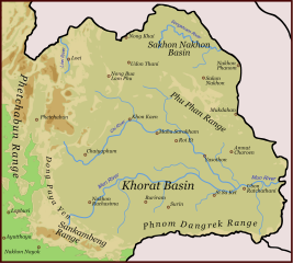
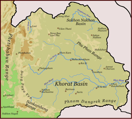
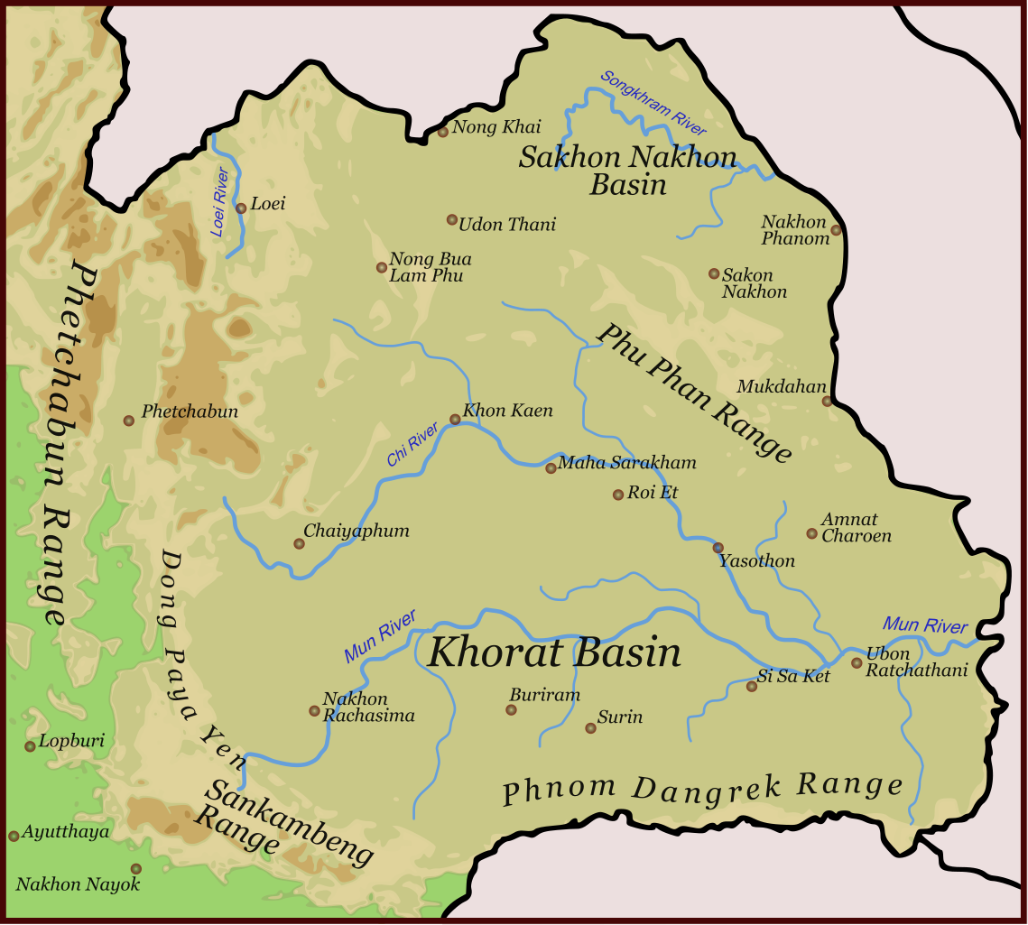
Дангрек Khorat Plateau Phetchabun Mountains Phu Phan Mountains Dângrêk Mountains Dong Phaya Yen Mountains Loei River Sankamphaeng Range Montañas Phetchabun फेत्चबून पहाड़ियाँ खोरात पठार Monti Phetchabun Monti Phu Phan ഫെറ്റ്ച്ചാബൻ മലനിരകൾ ഖൊറാത്ത് പീഠഭൂമി Чи (река) ภาพนี้มีข้อมูลเพิ่มเติม ซึ่งส่วนใหญ่มาจากกล้องดิจิตอลหรือสแกนเนอร์ที่สามารถเก็บข้อมูลดังกล่าวไว้รวมกับภาพได้ ถ้าภาพนี้ถูกปรับปรุงแก้ไขหรือเปลี่ยนแปลงจากเดิม ข้อมูลบางอย่างจะยังคงไม่เปลี่ยนแปลงเหมือนภาพที่ถูกปรับปรุงแก้ไขนั้น
ไฟล, isaanmountains, ไฟล, ประว, ไฟล, หน, าท, ภาพน, การใช, ไฟล, วนกลาง, อม, ลเก, ยวก, บภาพขนาดของต, วอย, าง, ของไฟล, กเซล, ความละเอ, ยดอ, กเซล, กเซล, กเซล, กเซล, กเซล, กเซล, ภาพท, ความละเอ, ยดส, งกว, 8206, ไฟล, กเซล, ขนาดไฟล, เมกะไบต, ปภาพหร, อไฟล, เส, ยงน, นฉบ. ifl prawtiifl hnathimiphaphni karichiflswnklang khxmulekiywkbphaphkhnadkhxngtwxyang PNG nikhxngifl SVG ni 667 600 phikesl khwamlaexiydxun 267 240 phikesl 534 480 phikesl 855 768 phikesl 1 139 1 024 phikesl 2 279 2 048 phikesl 672 604 phikesl duphaphthimikhwamlaexiydsungkwa 8206 ifl SVG 672 604 phikesl khnadifl 1 23 emkaibt rupphaphhruxiflesiyngni tnchbbxyuthi khxmmxns raylaexiyddanlang epnkhxkhwamthiaesdngphlcak ifltnchbbinkhxmmxns khxmmxnsepnewbistinokhrngkarsahrbekbrwbrwmsuxesri thi khunsamarthchwyid khaxthibayIsaanmountains svg English Physical orientation map of North East Thailandwnthi 13 mithunayn ph s 2551aehlngthima ngankhxngtwphusrangsrrkh Hdammkarxnuyat karichiflniihm khapheca inthanaphuthuxlikhsiththikhxngphaphhruxsuxni xnuyatihichphaphhruxsuxniphayitenguxnikhtxipni xnuyatihkhdlxk aeckcayaela hruxddaeprexksarniphayitenguxnikhkhxngsyyaxnuyatexksaresrikhxngknu run 1 2 hruxrunid nbcaknithixxkodymulnithisxftaewresri odyimmiswnidhamaekikh immikhxkhwampkhnaaelapkhlng saenakhxngsyyaxnuyatrwmxyuinswnchux syyaxnuyatexksaresrikhxngknuhttp www gnu org copyleft fdl html GFDL GNU Free Documentation License true trueThis file is licensed under the Creative Commons Attribution Share Alike 4 0 International 3 0 Unported 2 5 Generic 2 0 Generic and 1 0 Generic license khunsamarth thicaaebngpn thicathasaena aeckcay aelasngngandngklawtxip thicaeriyberiyngihm thicaddaeplngngandngklaw phayitenguxnikhtxipni aesdngthima khuntxngihekiyrtiecakhxngnganxyangehmaasm odyephimlingkipyngsyyaxnuyat aelarabuhakmikarepliynaeplng khunxacthaechnniidinrupaebbidkidtamkhwr aettxngimichinlksnathiaenawaphuihxnuyatsnbsnunkhunhruxkarichngankhxngkhun xnuyataebbediywkn hakkhunddaeplng epliynrup hruxtxetimnganni khuntxngichsyyaxnuyataebbediywknhruxaebbthiehmuxnkbsyyaxnuyatthiichkbnganniethannhttps creativecommons org licenses by sa 4 0 CC BY SA 4 0 Creative Commons Attribution Share Alike 4 0 true truekhunsamartheluxksyyaxnuyatdngklawtamtxngkarewxrchnxun Isaanmountains png iflphaphkrafiksewketxrimidrabukartrwcody W3C ni srangkhunodyich Inkscape khabrryayodyyxithyephimkhabrryaythrrthdediywephuxkhyaykhwamwaiflnimixairixethmthiaesdngxyuiniflniprakxbdwyphusrangbangkhathiimmiixethmwikisnethsyuxaraexl https commons wikimedia org wiki user Hdammchuxphuichwikimiediy Hdammhnathikhxngwtthuphayitpraphcnni changphaphchuxphusrangsrrkh HdammsthanalikhsiththimilikhsiththisyyaxnuyatCreative Commons Attribution ShareAlike 2 5 Generic xngkvsCreative Commons Attribution ShareAlike 1 0 Generic xngkvsCreative Commons Attribution ShareAlike 4 0 International xngkvsGNU Free Documentation License version 1 2 or later xngkvsCreative Commons Attribution ShareAlike 3 0 Unported xngkvsCreative Commons Attribution ShareAlike 2 0 Generic xngkvswnthisrang wnkxtng13 mithunayn 2008thimakhxngiflkarsrangdngedimodyphuxpohld prawtiifl khlikwnthi ewlaephuxduiflthipraktinkhnann wnthi ewlarupyxkhnadphuichkhwamehn pccubn19 07 6 mkrakhm 2560672 604 1 23 emkaibt Paul 012Shrink Dong Phaya Yen label since it encroached into the Eastern Petchabun Range area 20 28 17 knyayn 2551672 604 1 28 emkaibt Hdamm Information Description Source Date Author Permission other versions 22 05 22 singhakhm 25511 052 744 1 28 emkaibt Hdamm Information Description Source Date Author Permission other versions 15 53 13 mithunayn 2551672 604 1 22 emkaibt Hdamm Information Description Source Date Author Permission other versions 23 11 31 phvsphakhm 2551672 604 1 17 emkaibt Hdamm Information Description Source Date Author Permission other versions 20 40 31 phvsphakhm 2551672 604 769 kiolibt Hdamm Information Description Source Date Author Permission other versions 20 38 31 phvsphakhm 25511 052 744 768 kiolibt Hdamm Information Description en 1 Physical orientation map of North East Thailand Source Own work by uploader Author Hdamm Date 31 05 2008 Permission self GFDL cc by sa all other versions ImageUpload full Category C hnathimiphaphni hnatxipni oyngmathiphaphni thiwekhaphnmdngrk thirabsungokhrach phakhxisan praethsithy phuich NELLA32 rangphakhxisan karichiflswnklang wikixuntxipniichiflni karichbn ar wikipedia org هضبة كورات karichbn be wikipedia org Karat plato karichbn bg wikipedia org Korat Dangrek karichbn ca wikipedia org Altipla de Khorat karichbn de wikipedia org Phetchabun Gebirge karichbn en wikipedia org Isan Khorat Plateau Phetchabun Mountains Phu Phan Mountains Dangrek Mountains Dong Phaya Yen Mountains Loei River Sankamphaeng Range karichbn es wikipedia org Meseta de Khorat Montanas Phetchabun karichbn et wikipedia org Khorati magismaa karichbn eu wikipedia org Khorat goi ordokia karichbn hi wikipedia org ईस न फ त चब न पह ड य ख र त पठ र karichbn it wikipedia org Khorat altopiano Monti Phetchabun Monti Phu Phan karichbn ja wikipedia org コーラート台地 karichbn km wikipedia org ខ ពង រ បគ រ ជ karichbn ko wikipedia org 코랏 고원 karichbn lt wikipedia org Korato plynaukste karichbn ml wikipedia org ത യ ല ന റ ഫ റ റ ച ച ബൻ മലന രകൾ ഖ റ ത ത പ ഠഭ മ karichbn nl wikipedia org Chi rivier karichbn no wikipedia org Khoratplataet karichbn pt wikipedia org Planalto de Khorat karichbn ru wikipedia org Korat plato Chi reka karichbn sh wikipedia org Dong Faja Jen karichbn vi wikipedia org Cao nguyen Khorat karichbn www wikidata org Q874816 karichbn zh wikipedia org 呵叻高原khxmulekiywkbphaph phaphnimikhxmulephimetim sungswnihymacakklxngdicitxlhruxsaeknenxrthisamarthekbkhxmuldngklawiwrwmkbphaphid thaphaphnithukprbprungaekikhhruxepliynaeplngcakedim khxmulbangxyangcayngkhngimepliynaeplngehmuxnphaphthithukprbprungaekikhnnkhwamkwang671 65607khwamsung604 24072 ekhathungcak https th wikipedia org wiki ifl Isaanmountains svg, wikipedia, วิกิ หนังสือ, หนังสือ, ห้องสมุด,
บทความ , อ่าน, ดาวน์โหลด, ฟรี, ดาวน์โหลดฟรี, mp3, วิดีโอ, mp4, 3gp, jpg, jpeg, gif, png, รูปภาพ, เพลง, เพลง, หนัง, หนังสือ, เกม, เกม