azərbaycanca ∙ Deutsch (Sie-Form) ∙ čeština ∙ Deutsch ∙ sicilianu ∙ italiano ∙ русский ∙ română ∙ português ∙ English ∙ magyar ∙ Nederlands ∙ slovenščina ∙ polski ∙ latviešu ∙ македонски ∙ español ∙ فارسی ∙ français ∙ suomi ∙ עברית ∙ Plattdüütsch ∙ ქართული ∙ հայերեն ∙ বাংলা ∙ ไทย ∙ 日本語 ∙ 中文 ∙ 中文(简体) ∙ 中文(繁體) ∙ العربية ∙ +/−
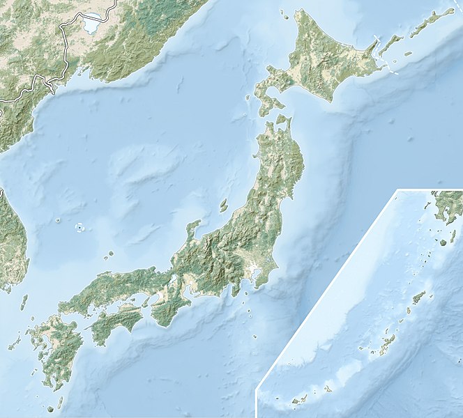
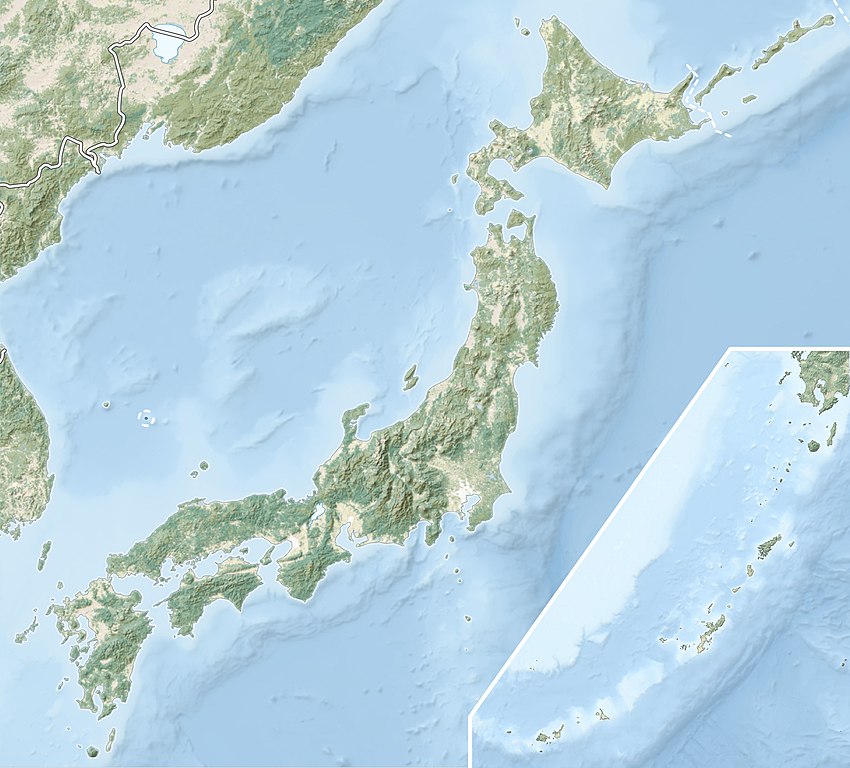
== {{int:filedesc}} == {{Information |Description= {{en|Natural Location map of Japan Equirectangular projection. Geographic limits to locate objects in the main map with the main islands: * N: 45°51'37" N (45.86°N) * S: 30°01'13" N (30.
Japan relief location mapEquirectangular projectionGeographic limits to locate objects in the side map with the Ryukyu Islands:N: 39°32'25" N (39.54°N)S: 23°42'36" N (23.71°N)W: 110°25'49" E (110.43°E)E: 131°26'25" E (131.44°E)
ความกว้าง
2,497 พิกเซล
ความสูง
2,256 พิกเซล
รูปแบบการบีบอัด
ไม่ได้บีบอัด
พิกเซลคอมโพซิชัน
RGB
การจัดวางภาพ
ปกติ
จำนวนคอมโพเนนต์
4
ความละเอียดแนวนอน
72 dpi
ความละเอียดแนวตั้ง
72 dpi
การจัดเรียงข้อมูล
รูปแบบชังกี
ซอฟต์แวร์ที่ใช้
Adobe Photoshop 23.2 (Windows)
แก้ไขภาพล่าสุด
15:38, 9 มีนาคม 2565
สเปซสี
sRGB
เวลาที่แปลงเป็นดิจิทัล
08:59, 8 มีนาคม 2565
วันที่แก้ไขข้อมูลเมตาล่าสุด
12:38, 9 มีนาคม 2565
ID เฉพาะของเอกสารต้นฉบับ
xmp.did:74a09a94-4fc9-c049-9dad-40d76abde775
สถานะลิขสิทธิ์
มีลิขสิทธิ์
ธันวาคม 27, 2022
ไฟล, japan, natural, location, with, side, ryukyu, islands, ไฟล, ประว, ไฟล, หน, าท, ภาพน, การใช, ไฟล, วนกลาง, อม, ลเก, ยวก, บภาพขนาดของต, วอย, างน, กเซล, ความละเอ, ยดอ, กเซล, กเซล, กเซล, กเซล, กเซล, ภาพท, ความละเอ, ยดส, งกว, 8206, กเซล, ขนาดไฟล, โลไบต, ชน, ดไม. ifl prawtiifl hnathimiphaphni karichiflswnklang khxmulekiywkbphaphkhnadkhxngtwxyangni 664 600 phikesl khwamlaexiydxun 266 240 phikesl 531 480 phikesl 850 768 phikesl 1 133 1 024 phikesl 2 497 2 256 phikesl duphaphthimikhwamlaexiydsungkwa 8206 2 497 2 256 phikesl khnadifl 830 kiolibt chnidimm image jpeg rupphaphhruxiflesiyngni tnchbbxyuthi khxmmxns raylaexiyddanlang epnkhxkhwamthiaesdngphlcak ifltnchbbinkhxmmxns khxmmxnsepnewbistinokhrngkarsahrbekbrwbrwmsuxesri thi khunsamarthchwyid khwamyx khaxthibayJapan natural location map with side map of the Ryukyu Islands jpg English Natural Location map of Japan Equirectangular projection Geographic limits to locate objects in the main map with the main islands N 45 51 37 N 45 86 N S 30 01 13 N 30 02 N W 128 14 24 E 128 24 E E 149 16 13 E 149 27 E Geographic limits to locate objects in the side map with the Ryukyu Islands N 39 32 25 N 39 54 N S 23 42 36 N 23 71 N W 110 25 49 E 110 43 E E 131 26 25 E 131 44 E wnthi minakhm ph s 2554aehlngthima File Japan location map with side map of the Ryukyu Islands svg Chumwa AVHRR Land Cover SRTM Data ETOPO1 Natural Earth 1 Ryukyu Islands phusrangsrrkh Alexrk2karxnuyat karichiflniihm iflnixyuphayitsyyaxnuyat khriexthifkhxmmxns aebbaesdngthima xnuyataebbediywkn 3 0 tnchbbkhunsamarth thicaaebngpn thicathasaena aeckcay aelasngngandngklawtxip thicaeriyberiyngihm thicaddaeplngngandngklaw phayitenguxnikhtxipni aesdngthima khuntxngihekiyrtiecakhxngnganxyangehmaasm odyephimlingkipyngsyyaxnuyat aelarabuhakmikarepliynaeplng khunxacthaechnniidinrupaebbidkidtamkhwr aettxngimichinlksnathiaenawaphuihxnuyatsnbsnunkhunhruxkarichngankhxngkhun xnuyataebbediywkn hakkhunddaeplng epliynrup hruxtxetimnganni khuntxngichsyyaxnuyataebbediywknhruxaebbthiehmuxnkbsyyaxnuyatthiichkbnganniethannhttps creativecommons org licenses by sa 3 0 CC BY SA 3 0 Creative Commons Attribution Share Alike 3 0 true trueewxrchnxun continuous map of Japan map of the main islands with a side map for the Ryukyu Islands Equivalent relief map Blue Marble Satellite imagery Natural Land cover aephnthinithuksranghruxphthnakhuncak Kartenwerkstatt hxngptibtikaraephnthi khxngwikiphiediyphasaeyxrmn sungkhunsamarthesnxaephnthiephuxphthnaidechnediywkn azerbaycanca Deutsch Sie Form cestina Deutsch sicilianu italiano russkij romană portugues English magyar Nederlands slovenscina polski latviesu makedonski espanol فارسی francais suomi עברית Plattduutsch ქართული հայերեն ব ল ithy 日本語 中文 中文 简体 中文 繁體 العربية khabrryayodyyxithyephimkhabrryaythrrthdediywephuxkhyaykhwamwaiflnimixairxngkvs1933 Sanriku earthquakeeyxrmnOst Sud KustecintwetmEast North Coastixethmthiaesdngxyuiniflniprakxbdwy1933 Sanriku earthquake xngkvssthanalikhsiththimilikhsiththisyyaxnuyatCreative Commons Attribution ShareAlike 3 0 Unported xngkvswnthisrang wnkxtngminakhm 2011MIME type xngkvsimage jpeg prawtiifl khlikwnthi ewlaephuxduiflthipraktinkhnann wnthi ewlarupyxkhnadphuichkhwamehn pccubn04 41 10 minakhm 25652 497 2 256 830 kiolibt StingNatural Earth land cover data for Ryukyu Islands 16 44 22 mithunayn 25612 497 2 256 794 kiolibt MardetanhaReverted to version as of 19 56 22 March 2011 UTC 02 56 23 minakhm 25542 497 2 256 794 kiolibt Alexrk2RGB 02 07 23 minakhm 25542 497 2 256 745 kiolibt ChumwaRGB mode 04 08 22 minakhm 25542 497 2 256 1 54 emkaibt Alexrk2 int filedesc Information Description en Natural Location map of Japan Equirectangular projection Geographic limits to locate objects in the main map with the main islands N 45 51 039 37 N 45 86 N S 30 01 039 13 N 30 hnathimiphaphni hnatxipni oyngmathiphaphni khabsmuthrkhixi khabsmuthrchimabara khioymisuedra chxngaekhbkhixi chxngaekhbbungonga chxngaekhbxakachi sakuracima sakobranthachiraohasaoxentabaru thaelsabkhasumingaxura thaelsabkhawanguci thaelsabkhuchchaora thaelsabchiktsu thaelsabchinci thaelsabchuesnci thaelsabsaorma thaelsabsuwa thaelsabnakaxumi thaelsabbiwa thaelsabmachu thaelsabyamanaka thaelsabxinawachiora thaelsabhaciorngata thaelsabhamana thaelsabochci thaelsabothya thaelsabothwada thaelsabomotsu thaelsabis natkchiraxiota natkekhngng prasathsuwahara phuekhakhita phuekhafuci phuekhawakakusa yuththkarthiokhmakiaelanangakueta raychuxaehlngmrdkolkinpraethsyipun salecathaekda xuthyanaehngchatifuci haokena xisu xawwakasa xawxucixura xawotekiyw ekhakhngong ekhaxasama aephndinihwpiohex kh s 1707 aephndinihweknorku ph s 2246 aephndinihwaelakhlunsunamiinxunesn kh s 1792 aephndinihwaelakhlunsunamiinothohku ph s 2554 aephndinihwaelakhlunsunamiinoxkuchiri ph s 2536 aephndinihwincnghwdkhumaomota kh s 2016 aephndinihwincnghwdchiba kh s 2021 aephndinihwincnghwdfukuchima kh s 2022 aephndinihwincnghwdfukuchima ph s 2559 aephndinihwincnghwdfukuchima ph s 2564 aephndinihwincnghwdoxsaka ph s 2561 aephndinihwinchuextsu ph s 2547 aehlngmawaki okheba othbuewildsaekhwr phuich ZilentFyld saved phuekhahakhu aemaebb Location map Japan mxdul Location map data Japan mxdul Location map data Japan doc karichiflswnklang wikixuntxipniichiflni karichbn ace wikipedia org Pola Location map Japan karichbn als wikipedia org Vorlage Infobox Berg Vorlage Positionskarte Japan Vorlage Infobox Berg Doku karichbn ar wikipedia org 1983 قالب خريطة مواقع اليابان متحف ناغاساكي للقنبلة الذرية قالب Location map relief مسجد دار الأرقم زلازل كوماموتو 2016 متحف العلوم البحرية زلزال كيتا تانغو 1927 زلزال مياغي 2021 زلزال مياغي 1936 زلزال تونانكاي 1944 karichbn arz wikipedia org قالب Location map relief قالب خريطة مواقع اليابان اطلال كهف شيراهو سونيتابارو karichbn ast wikipedia org Modulu Minimapa data Xapon Modulu Minimapa data Xapon usu Plantia Minimapa relief karichbn as wikipedia org ১৯৬৪ চনৰ ন গ ট ভ ম কম প Module Location map data Japan Module Location map data Japan doc karichbn azb wikipedia org کوبه هیوقو شابلون Location map Japan karichbn az wikipedia org Hokkaydo Kyusu Fuci Honsu Itsukusima Asama Sablon Yer xeritesi Yaponiya Senday zelzelesi ve sunami 2011 Fukusima 1 AES Boyuk Hansin zelzelesi Boyuk Kanto zelzelesi Hoey zelzelesi Mino Ovari zelzelesi 1891 Yapon cokekliyi Ryukyu adalari Osumi bogazi Sanqar bogazi Koreya bogazi Tsusima bogazi Harim denizi Yatsusiro denizi Hiuqa denizi Daxili Yapon denizi Atsumi yarimadasi dukarichthwolkephimetimkhxngiflnikhxmulekiywkbphaph phaphnimikhxmulephimetim sungswnihymacakklxngdicitxlhruxsaeknenxrthisamarthekbkhxmuldngklawiwrwmkbphaphid thaphaphnithukprbprungaekikhhruxepliynaeplngcakedim khxmulbangxyangcayngkhngimepliynaeplngehmuxnphaphthithukprbprungaekikhnnphuthrnglikhsiththiEric Gaba for Wikimedia Commons CC BY SAchuxphaphJapan relief location mapEquirectangular projectionGeographic limits to locate objects in the side map with the Ryukyu Islands N 39 32 25 amp quot N 39 54 N S 23 42 36 amp quot N 23 71 N W 110 25 49 amp quot E 110 43 E E 131 26 25 amp quot E 131 44 E khwamkwang2 497 phikeslkhwamsung2 256 phikeslrupaebbkarbibxdimidbibxdphikeslkhxmophsichnRGBkarcdwangphaphpkticanwnkhxmophennt4khwamlaexiydaenwnxn72 dpikhwamlaexiydaenwtng72 dpikarcderiyngkhxmulrupaebbchngkisxftaewrthiichAdobe Photoshop 23 2 Windows aekikhphaphlasud15 38 9 minakhm 2565sepssisRGBewlathiaeplngepndicithl08 59 8 minakhm 2565wnthiaekikhkhxmulemtalasud12 38 9 minakhm 2565ID echphaakhxngexksartnchbbxmp did 74a09a94 4fc9 c049 9dad 40d76abde775sthanalikhsiththimilikhsiththi ekhathungcak https th wikipedia org wiki ifl Japan natural location map with side map of the Ryukyu Islands jpg, wikipedia, วิกิ หนังสือ, หนังสือ, ห้องสมุด,