This map is available from the United States Library of Congress's Geography & Map Division under the digital ID g7653j.ct000803. This tag does not indicate the copyright status of the attached work. A normal copyright tag is still required.See Commons:Licensing.
العربية ∙ беларуская (тарашкевіца) ∙ বাংলা ∙ čeština ∙ Deutsch ∙ English ∙ español ∙ فارسی ∙ suomi ∙ français ∙ galego ∙ עברית ∙ magyar ∙ Bahasa Indonesia ∙ italiano ∙ 日本語 ∙ lietuvių ∙ македонски ∙ മലയാളം ∙ Nederlands ∙ polski ∙ português ∙ português do Brasil ∙ română ∙ русский ∙ sicilianu ∙ slovenčina ∙ slovenščina ∙ Türkçe ∙ українська ∙ 简体中文 ∙ 繁體中文 ∙ +/−
Library of Congress Geography and Map Division Washington, D.C. 20540-4650 USA
ผู้สร้างสรรค์
Central Intelligence Agency, Washington, 2002
การอนุญาตใช้สิทธิ
Public domainPublic domainfalsefalse
Old file history
taken from de.wiki there under PD with description
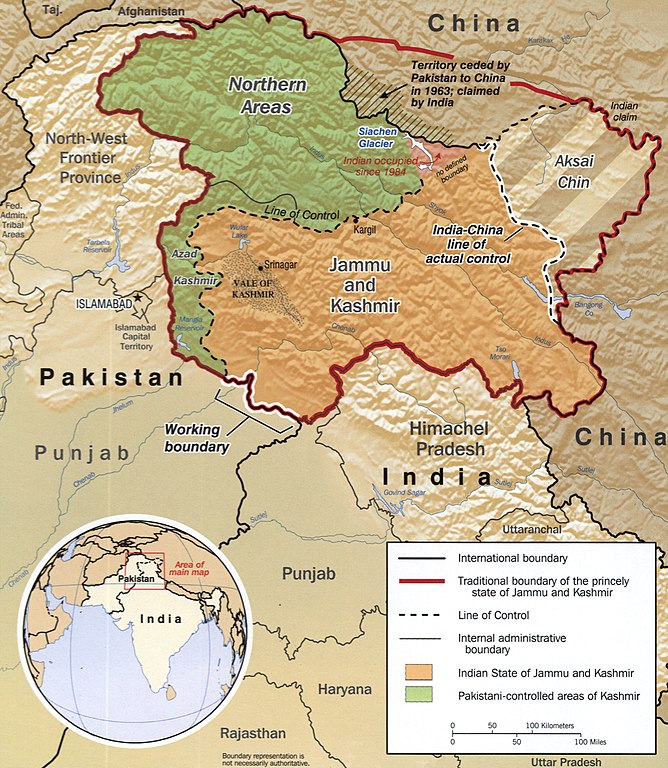
ไฟล, kashmir, ไฟล, ประว, ไฟล, หน, าท, ภาพน, การใช, ไฟล, วนกลาง, อม, ลเก, ยวก, บภาพขนาดของต, วอย, างน, กเซล, ความละเอ, ยดอ, กเซล, กเซล, กเซล, กเซล, กเซล, ภาพท, ความละเอ, ยดส, งกว, 8206, กเซล, ขนาดไฟล, เมกะไบต, ชน, ดไมม, image, jpeg, ปภาพหร, อไฟล, เส, ยงน, นฉบ, . ifl prawtiifl hnathimiphaphni karichiflswnklang khxmulekiywkbphaphkhnadkhxngtwxyangni 522 600 phikesl khwamlaexiydxun 209 240 phikesl 418 480 phikesl 668 768 phikesl 891 1 024 phikesl 1 951 2 242 phikesl duphaphthimikhwamlaexiydsungkwa 8206 1 951 2 242 phikesl khnadifl 2 32 emkaibt chnidimm image jpeg rupphaphhruxiflesiyngni tnchbbxyuthi khxmmxns raylaexiyddanlang epnkhxkhwamthiaesdngphlcak ifltnchbbinkhxmmxns khxmmxnsepnewbistinokhrngkarsahrbekbrwbrwmsuxesri thi khunsamarthchwyid Pir gali shahdra Sharif khwamyx khaxthibayKashmir map big jpg English The disputed area of Kashmir Notes 760279AI R00744 6 02 Relief shown by shading Includes location map Medium 1 map nbsp col nbsp 20 x 17 cm Call Number G7653 J3F2 2002 U5 Control Number 2002626371 Digital ID g7653j ct000803 http hdl loc gov loc gmd g7653j ct000803 wnthi ph s 2545 CREATED PUBLISHED aehlngthima nbsp This map is available from the United States Library of Congress s Geography amp Map Division under the digital ID g7653j ct000803 This tag does not indicate the copyright status of the attached work A normal copyright tag is still required See Commons Licensing العربية nbsp belaruskaya tarashkevica nbsp ব ল nbsp cestina nbsp Deutsch nbsp English nbsp espanol nbsp فارسی nbsp suomi nbsp francais nbsp galego nbsp עברית nbsp magyar nbsp Bahasa Indonesia nbsp italiano nbsp 日本語 nbsp lietuviu nbsp makedonski nbsp മലയ ള nbsp Nederlands nbsp polski nbsp portugues nbsp portugues do Brasil nbsp romană nbsp russkij nbsp sicilianu nbsp slovencina nbsp slovenscina nbsp Turkce nbsp ukrayinska nbsp 简体中文 nbsp 繁體中文 nbsp Library of Congress Geography and Map Division Washington D C 20540 4650 USA phusrangsrrkh Central Intelligence Agency Washington 2002 karxnuyatichsiththi Public domain Public domain false false This image is a work of a Central Intelligence Agency employee taken or made as part of that person s official duties As a Work of the United States Government this image or media is in the public domain in the United States cestina nbsp Deutsch nbsp eesti nbsp English nbsp espanol nbsp francais nbsp italiano nbsp portugues nbsp polski nbsp sicilianu nbsp slovenscina nbsp suomi nbsp Tiếng Việt nbsp blgarski nbsp makedonski nbsp russkij nbsp ukrayinska nbsp ব ল nbsp മലയ ള nbsp 한국어 nbsp 日本語 nbsp 中文 nbsp 中文 简体 nbsp 中文 繁體 nbsp العربية nbsp پښتو nbsp Old file history taken from de wiki there under PD with descriptionkhabrryayodyyxithyephimkhabrryaythrrthdediywephuxkhyaykhwamwaiflnimixairixethmthiaesdngxyuiniflniprakxbdwysthanalikhsiththisatharnsmbtiwnthisrang wnkxtng2002MIME type nbsp xngkvsimage jpeg prawtiifl khlikwnthi ewlaephuxduiflthipraktinkhnann wnthi ewlarupyxkhnadphuichkhwamehn pccubn00 04 3 thnwakhm 25611 951 2 242 2 32 emkaibt Ras67new cropped from LOC 039 s high resolution TIFF 05 23 8 minakhm 2549985 1 131 274 kiolibt Sven steffen arndt hnathimiphaphni hnatxipni oyngmathiphaphni krniphiphatheruxngxanaekht sngkhramcin xinediy esnkhwbkhumaethcring karichiflswnklang wikixuntxipniichiflni karichbn ar wikipedia org كشمير نزاع كشمير قالب إطار ثلاثي الأبعاد نزاع إقليمي بوابة الهند مقالة مختارة أرشيف بوابة الهند مقالة مختارة 12 قالب إطار ثلاثي الأبعاد شرح karichbn ast wikipedia org Jammu y Caxmir karichbn as wikipedia org ভ ৰত চ ন য দ ধ karichbn azb wikipedia org کشمیر karichbn az wikipedia org Kesmir Aksaycin Portal Hindistan Tarixe nezer Portal Hindistan karichbn ba wikipedia org Kәshmir karichbn be tarask wikipedia org Kashmir karichbn be wikipedia org Kashmir karichbn bh wikipedia org ल इन ऑफ एक च अल क ट र ल कर क रम प र इल क karichbn bn wikipedia org চ ন ভ রত য দ ধ ভ রত র র জন ত ক একত র করণ প রক ত ন য ন ত রণ র খ karichbn ca wikipedia org Caixmir Extensio Trans Karakoram Conflicte del Caixmir Linia actual de control karichbn cs wikipedia org Kasmir Azad Kasmir karichbn diq wikipedia org Kesmir karichbn en wikipedia org Sino Indian War Political integration of India Military history of Pakistan 1949 in Pakistan China Pakistan relations Ardagh Johnson Line User MohibUMirza sandbox karichbn eo wikipedia org Kaŝmiro karichbn es wikipedia org Cachemira region Estado de Jammu y Cachemira Yihadismo Guerra sino india Valle Shaksgam Conflicto de Cachemira Linea de control real Linea de control Insurgencia en Jammu y Cachemira Incidentes fronterizos entre India y Pakistan de 2013 Frontera entre China y Pakistan Frontera entre Pakistan e India karichbn eu wikipedia org Kaxmir dukarichthwolkephimetimkhxngiflnikhxmulekiywkbphaph phaphnimikhxmulephimetim sungswnihymacakklxngdicitxlhruxsaeknenxrthisamarthekbkhxmuldngklawiwrwmkbphaphid thaphaphnithukprbprungaekikhhruxepliynaeplngcakedim khxmulbangxyangcayngkhngimepliynaeplngehmuxnphaphthithukprbprungaekikhnnkhwamkwang2 007 phikeslkhwamsung2 392 phikeslbittxkhxmophennt8 8 8rupaebbkarbibxdimidbibxdphikeslkhxmophsichnRGBkarcdwangphaphpkticanwnkhxmophennt3khwamlaexiydaenwnxn300 dpikhwamlaexiydaenwtng300 dpikarcderiyngkhxmulrupaebbchngkisxftaewrthiichAdobe Photoshop CS Windowsaekikhphaphlasud17 52 2 thnwakhm 2561ewlathiaeplngepndicithl17 01 4 tulakhm 2548sepssisRGBwnthiaekikhkhxmulemtalasud12 01 4 tulakhm 2548 ekhathungcak https th wikipedia org wiki ifl Kashmir map big jpg, wikipedia, วิกิ หนังสือ, หนังสือ, ห้องสมุด,