English: Leverkusen in Germany, photographed by astronauts aboard the Space Shuttle.
Original image courtesy of the Image Analysis Laboratory, NASA Johnson Space Center (eol.jsc.nasa.gov). Image ID: STS061-75-48. Image cropped, sharpened and gamma-corrected.
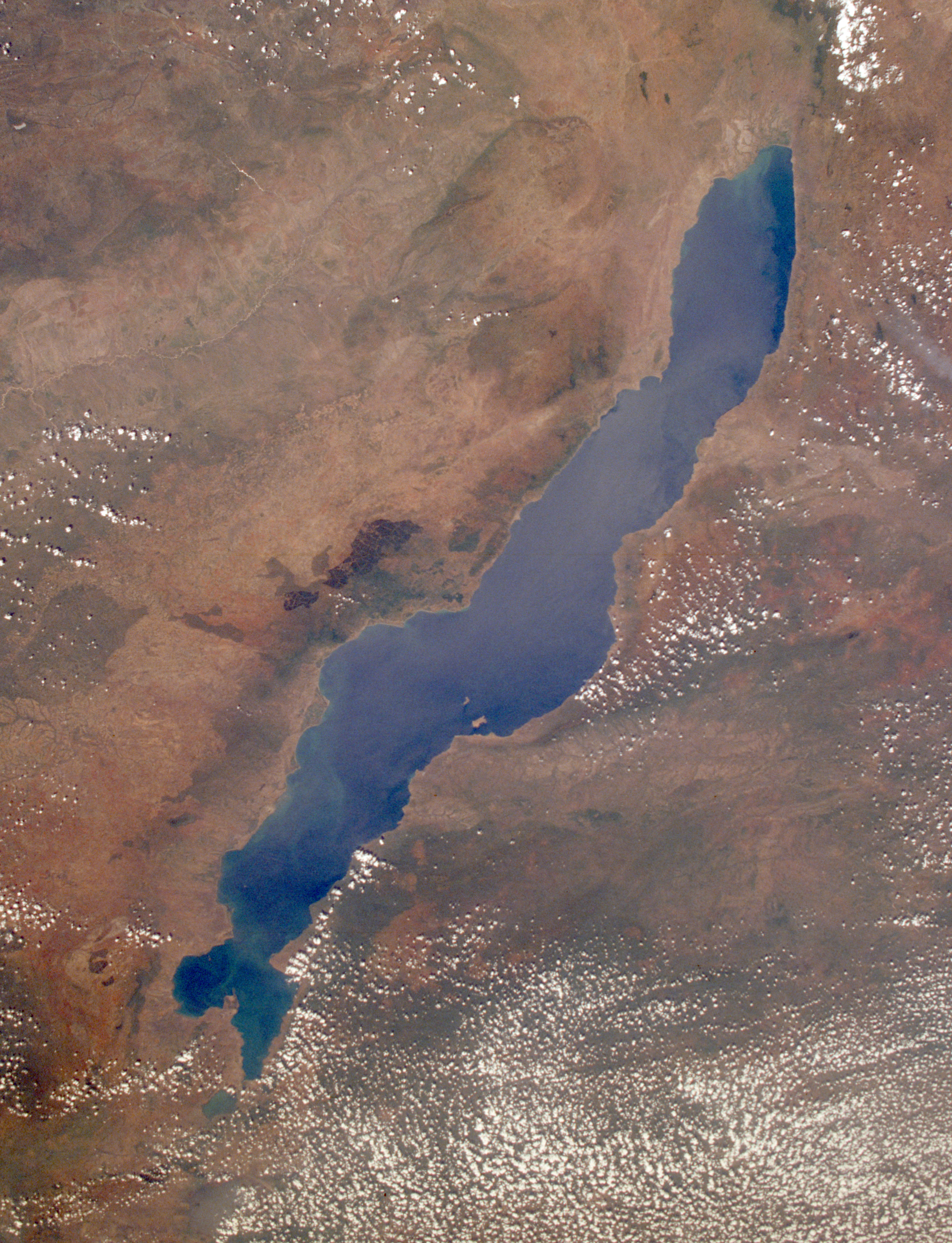
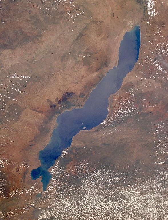
This low-oblique, southeast-looking photograph shows Lake Malawi, one of many elongated lakes that form part of the Great Rift Valley of east Africa. The lake, bounded by steep mountains on all sides except the southern end, is approximately 360 miles (580 kilometers) long, averages 25 miles (40 kilometers) in width, and has a maximum depth of 2316 feet (706 meters). Lake Malawi is drained at the south end by the Shire River, which eventually empties into the Zambezi River. The lake and its steep-sloped shoreline were created by faulting that caused a thrust upward as the valley floor subsided between the slopes. The darker area along the northwest coast of the lake is the Nyika Plateau, which has several elevations more than 8000 feet (2440 meters) above sea level. Landlocked Malawi extends along the entire west coast of the lake. The large Luangwa River basin is visible as it drains to the southwest. Immediately west of the Luangwa River Valley stand the northeast-southwest-trending Muchinga Mountains with their dark ridgeline and maximum elevations reaching 6000 feet (1830 meters) above sea level. Northwest of this mountain range, drainage is to the north and west into the much larger Zaire (Congo) River watershed.
National Aeronautics and Space Administration (NASA)
เวอร์ชันอื่น
This file has been extracted from another file: [1]. The source image was deleted for reasons that do not affect this image, like a derivative work which is not a part of this cropped image.
This image or video was catalogued by Johnson Space Center of the United States National Aeronautics and Space Administration (NASA) under Photo ID: STS061-75-48.
This tag does not indicate the copyright status of the attached work. A normal copyright tag is still required.See Commons:Licensing.العربية ∙ беларуская (тарашкевіца) ∙ български ∙ català ∙ čeština ∙ dansk ∙ Deutsch ∙ English ∙ español ∙ فارسی ∙ français ∙ galego ∙ magyar ∙ հայերեն ∙ Bahasa Indonesia ∙ italiano ∙ 日本語 ∙ македонски ∙ മലയാളം ∙ Nederlands ∙ polski ∙ português ∙ русский ∙ sicilianu ∙ Türkçe ∙ українська ∙ 简体中文 ∙ 繁體中文 ∙ +/−
การอนุญาตใช้สิทธิ
Public domainPublic domainfalsefalse
บันทึกการอัพโหลด
Uploaded to en wiki by User:Worldtraveller; moved here by User:Tintazul. Full original description follows.
''Uploaded to en wiki by User:Worldtraveller; moved here by User:Tintazul. Full original description follows.'' Lake Malawi in Africa, photographed by astronauts aboard the Space Shuttle. Original image courtesy of the Image Analysis Laboratory,
ไฟล, lake, malawi, seen, from, orbit, ไฟล, ประว, ไฟล, หน, าท, ภาพน, การใช, ไฟล, วนกลาง, อม, ลเก, ยวก, บภาพขนาดของต, วอย, างน, กเซล, ความละเอ, ยดอ, กเซล, กเซล, กเซล, กเซล, กเซล, กเซล, ภาพท, ความละเอ, ยดส, งกว, 8206, กเซล, ขนาดไฟล, เมกะไบต, ชน, ดไมม, image, jpeg. ifl prawtiifl hnathimiphaphni karichiflswnklang khxmulekiywkbphaphkhnadkhxngtwxyangni 459 599 phikesl khwamlaexiydxun 184 240 phikesl 367 480 phikesl 588 768 phikesl 784 1 024 phikesl 1 568 2 048 phikesl 2 778 3 628 phikesl duphaphthimikhwamlaexiydsungkwa 8206 2 778 3 628 phikesl khnadifl 3 24 emkaibt chnidimm image jpeg rupphaphhruxiflesiyngni tnchbbxyuthi khxmmxns raylaexiyddanlang epnkhxkhwamthiaesdngphlcak ifltnchbbinkhxmmxns khxmmxnsepnewbistinokhrngkarsahrbekbrwbrwmsuxesri thi khunsamarthchwyid khwamyx khaxthibayLake Malawi seen from orbit jpg English Leverkusen in Germany photographed by astronauts aboard the Space Shuttle Original image courtesy of the Image Analysis Laboratory NASA Johnson Space Center eol jsc nasa gov Image ID STS061 75 48 Image cropped sharpened and gamma corrected This low oblique southeast looking photograph shows Lake Malawi one of many elongated lakes that form part of the Great Rift Valley of east Africa The lake bounded by steep mountains on all sides except the southern end is approximately 360 miles 580 kilometers long averages 25 miles 40 kilometers in width and has a maximum depth of 2316 feet 706 meters Lake Malawi is drained at the south end by the Shire River which eventually empties into the Zambezi River The lake and its steep sloped shoreline were created by faulting that caused a thrust upward as the valley floor subsided between the slopes The darker area along the northwest coast of the lake is the Nyika Plateau which has several elevations more than 8000 feet 2440 meters above sea level Landlocked Malawi extends along the entire west coast of the lake The large Luangwa River basin is visible as it drains to the southwest Immediately west of the Luangwa River Valley stand the northeast southwest trending Muchinga Mountains with their dark ridgeline and maximum elevations reaching 6000 feet 1830 meters above sea level Northwest of this mountain range drainage is to the north and west into the much larger Zaire Congo River watershed wnthi Taken on 3 thnwakhm ph s 2541 09 49 31 UTCaehlngthima https eol jsc nasa gov SearchPhotos photo pl mission STS061 amp roll 75 amp frame 48phusrangsrrkh National Aeronautics and Space Administration NASA ewxrchnxun This file has been extracted from another file 1 The source image was deleted for reasons that do not affect this image like a derivative work which is not a part of this cropped image This image or video was catalogued by Johnson Space Center of the United States National Aeronautics and Space Administration NASA under Photo ID STS061 75 48 This tag does not indicate the copyright status of the attached work A normal copyright tag is still required See Commons Licensing العربية belaruskaya tarashkevica blgarski catala cestina dansk Deutsch English espanol فارسی francais galego magyar հայերեն Bahasa Indonesia italiano 日本語 makedonski മലയ ള Nederlands polski portugues russkij sicilianu Turkce ukrayinska 简体中文 繁體中文 karxnuyatichsiththi Public domain Public domain false falseThis file is in the public domain in the United States because it was created by the Image Science amp Analysis Laboratory of the NASA Johnson Space Center NASA copyright policy states that NASA material is not protected by copyright unless noted NASA media use guidelines or Conditions of Use of Astronaut Photographs Photo source STS061 75 48 العربي ة Deutsch English espanol francais italiano kurdi makedonski മലയ ള portugues sicilianu bnthukkarxphohld Uploaded to en wiki by User Worldtraveller moved here by User Tintazul Full original description follows khabrryayodyyxithyephimkhabrryaythrrthdediywephuxkhyaykhwamwaiflnimixairxngkvsLake MalawieyxrmnMalawiseeixethmthiaesdngxyuiniflniprakxbdwythaelsabmalawithaelsabsthanalikhsiththisatharnsmbtidetermination method xngkvs work of the federal government of the United States xngkvswnthisrang wnkxtng3 thnwakhm 1993catalog code xngkvsSTS061 75 48aekhttalxk Media catalogue of the Johnson Space Center xngkvsMIME type xngkvsimage jpeg prawtiifl khlikwnthi ewlaephuxduiflthipraktinkhnann wnthi ewlarupyxkhnadphuichkhwamehn pccubn02 17 31 singhakhm 25622 778 3 628 3 24 emkaibt Ras67high resolution cropped and rotated from NASA 039 s original TIFF 19 27 4 phvscikayn 2548768 1 000 271 kiolibt Tintazul 039 039 Uploaded to en wiki by User Worldtraveller moved here by User Tintazul Full original description follows 039 039 Lake Malawi in Africa photographed by astronauts aboard the Space Shuttle Original image courtesy of the Image Analysis Laboratory hnathimiphaphni hnatxipni oyngmathiphaphni thaelsabmalawi karichiflswnklang wikixuntxipniichiflni karichbn af wikipedia org Malawimeer karichbn als wikipedia org Malawisee karichbn ar wikipedia org بحيرة ملاوي karichbn arz wikipedia org تشعب تطور بحيرة ملاوى الميلانكروميس اولونوكارا زيبرا مبونا ليثرينوبس مايلانديا مايلانديا اميلتوس مايلانديا اورورا مايلانديا ثابسينوجين مايلانديا كريسومالوس هاب المياة العميقه وليامز مبونا karichbn az wikipedia org Nyasa Afrikanin boyuk golleri karichbn bar wikipedia org Malawisee Malawi karichbn ba wikipedia org Nyasa karichbn be tarask wikipedia org Malavi vozera karichbn be wikipedia org Malavi vozera karichbn bg wikipedia org Dimidiochromis compressiceps Labeotropheus trewavasae Labidochromis caeruleus Maylandia aurora Maylandia barlowi Maylandia benetos Maylandia callainos Maylandia chrysomallos Maylandia elegans Maylandia emmiltos Maylandia estherae Maylandia hajomaylandi Maylandia heteropicta Maylandia lombardoi Maylandia mbenjii Maylandia melabranchion Maylandia phaeos Maylandia pursa Maylandia pyrsonotos Maylandia thapsinogen Maylandia zebra Melanochromis parallelus Nimbochromis linni Nimbochromis polystigma Otopharynx brooksi Otopharynx lithobates Otopharynx tetrastigma dukarichthwolkephimetimkhxngiflnikhxmulekiywkbphaph phaphnimikhxmulephimetim sungswnihymacakklxngdicitxlhruxsaeknenxrthisamarthekbkhxmuldngklawiwrwmkbphaphid thaphaphnithukprbprungaekikhhruxepliynaeplngcakedim khxmulbangxyangcayngkhngimepliynaeplngehmuxnphaphthithukprbprungaekikhnnchuxphaphLake Malawi Lake Nyasa Malawi December 1993phuphlitklxngHasselbladphuthayNASAewlathibnthukphaph09 49 3 thnwakhm 2536khwamyawofkselns40 mm khwamkwang5 700 phikeslkhwamsung6 000 phikeslbittxkhxmophennt16 16 16rupaebbkarbibxdimidbibxdphikeslkhxmophsichnRGBkarcdwangphaphpkticanwnkhxmophennt3khwamlaexiydaenwnxn300 dpikhwamlaexiydaenwtng300 dpikarcderiyngkhxmulrupaebbchngkisxftaewrthiichAdobe Photoshopaekikhphaphlasud18 48 30 singhakhm 2562ewlathiaeplngepndicithl08 53 5 mkrakhm 2555khwamehnphuichOxscan v 0092042202 ekhathungcak https th wikipedia org wiki ifl Lake Malawi seen from orbit jpg, wikipedia, วิกิ หนังสือ, หนังสือ, ห้องสมุด,