| | รูปภาพหรือไฟล์เสียงนี้ ต้นฉบับอยู่ที่ คอมมอนส์ รายละเอียดด้านล่าง เป็นข้อความที่แสดงผลจาก ไฟล์ต้นฉบับในคอมมอนส์ คอมมอนส์เป็นเว็บไซต์ในโครงการสำหรับเก็บรวบรวมสื่อเสรี ที่ คุณสามารถช่วยได้ |
ความย่อ
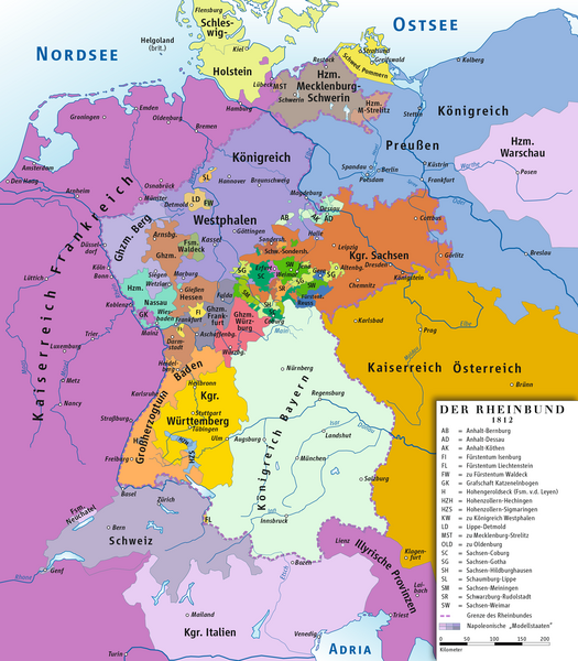
| คำอธิบายRheinbund 1812, political map.png | Deutsch: Karte des Rheinbundes 1812 English: Map of Confederation of the Rhine 1812 |
| วันที่ | |
| แหล่งที่มา | งานของตัว drawing/Source of Information: Putzger – Historischer Weltatlas, 89. Auflage, 1965; Westermanns Großer Atlas zuur Weltgeschichte, 1969; Haacks geographischer Atlas. VEB Hermann Haack Geographisch-Kartographische Anstalt, Gotha/Leipzig, 1. Auflage, 1979. |
| ผู้สร้างสรรค์ | ziegelbrenner |
การอนุญาต
(การใช้ไฟล์นี้ใหม่) | ข้าพเจ้า ในฐานะผู้ถือลิขสิทธิ์ของภาพหรือสื่อนี้ อนุญาตให้ใช้ภาพหรือสื่อนี้ภายใต้เงื่อนไขต่อไปนี้ | อนุญาตให้คัดลอก แจกจ่ายและ/หรือดัดแปรเอกสารนี้ภายใต้เงื่อนไขของสัญญาอนุญาตเอกสารเสรีของกนู รุ่น 1.2 หรือรุ่นใด ๆ นับจากนี้ที่ออกโดยมูลนิธิซอฟต์แวร์เสรี โดยไม่มีส่วนใดห้ามแก้ไข ไม่มีข้อความปกหน้าและปกหลัง สำเนาของสัญญาอนุญาตรวมอยู่ในส่วนชื่อ สัญญาอนุญาตเอกสารเสรีของกนูhttp://www.gnu.org/copyleft/fdl.htmlGFDLGNU Free Documentation Licensetruetrue |
| ไฟล์นี้อยู่ภายใต้สัญญาอนุญาต ครีเอทีฟคอมมอนส์ แบบแสดงที่มา-อนุญาตแบบเดียวกัน 3.0 ต้นฉบับ | | | | - คุณสามารถ:
- ที่จะแบ่งปัน – ที่จะทำสำเนา แจกจ่าย และส่งงานดังกล่าวต่อไป
- ที่จะเรียบเรียงใหม่ – ที่จะดัดแปลงงานดังกล่าว
- ภายใต้เงื่อนไขต่อไปนี้:
- แสดงที่มา – คุณต้องให้เกียรติเจ้าของงานอย่างเหมาะสม โดยเพิ่มลิงก์ไปยังสัญญาอนุญาต และระบุหากมีการเปลี่ยนแปลง คุณอาจทำเช่นนี้ได้ในรูปแบบใดก็ได้ตามควร แต่ต้องไม่ใช่ในลักษณะที่แนะว่าผู้ให้อนุญาตสนับสนุนคุณหรือการใช้งานของคุณ
- อนุญาตแบบเดียวกัน – หากคุณดัดแปลง เปลี่ยนรูป หรือต่อเติมงานนี้ คุณต้องใช้สัญญาอนุญาตแบบเดียวกันหรือแบบที่เหมือนกับสัญญาอนุญาตที่ใช้กับงานนี้เท่านั้น
| | ป้ายแสดงสถานะลิขสิทธิ์นี้ถูกเพิ่มเพื่อให้เป็นไปตามการเปลี่ยนแปลงสัญญาอนุญาตของมูลนิธิวิกิมีเดีย จาก GFDL ไปยัง GFDL ควบคู่กับ CC-BY-SA 3.0http://creativecommons.org/licenses/by-sa/3.0/CC-BY-SA-3.0Creative Commons Attribution-Share Alike 3.0truetrue |
ไฟล์นี้อยู่ภายใต้สัญญาอนุญาตครีเอทีฟคอมมอนส์ รุ่นแสดงที่มา 2.5 ทั่วไป - คุณสามารถ:
- ที่จะแบ่งปัน – ที่จะทำสำเนา แจกจ่าย และส่งงานดังกล่าวต่อไป
- ที่จะเรียบเรียงใหม่ – ที่จะดัดแปลงงานดังกล่าว
- ภายใต้เงื่อนไขต่อไปนี้:
- แสดงที่มา – คุณต้องให้เกียรติเจ้าของงานอย่างเหมาะสม โดยเพิ่มลิงก์ไปยังสัญญาอนุญาต และระบุหากมีการเปลี่ยนแปลง คุณอาจทำเช่นนี้ได้ในรูปแบบใดก็ได้ตามควร แต่ต้องไม่ใช่ในลักษณะที่แนะว่าผู้ให้อนุญาตสนับสนุนคุณหรือการใช้งานของคุณ
https://creativecommons.org/licenses/by/2.5CC BY 2.5 Creative Commons Attribution 2.5 truetrueคุณสามารถเลือกสัญญาอนุญาตดังกล่าวตามต้องการ |
| ภาพแผนที่ทางประวัติศาสตร์นี้ ควรจะถูกสร้างใหม่เป็นกราฟิกส์เวกเตอร์ ซึ่งมีข้อดีอีกหลายประการ ดูเพิ่มเติมที่คอมมอนส์:สื่อต้องการเก็บกวาดสำหรับสารสนเทศเพิ่มเติม หากภาพนี้มีในรูปแบบกราฟิกส์เวกเตอร์อยู่แล้ว กรุณาอัปโหลดและแทนที่แม่แบบนี้ด้วย {{vector version available|ชื่อภาพใหม่}}
แนะนำเป็นอย่างยิ่งให้ตั้งชื่อไฟล์เวกเตอร์ใหม่นั้นในรูปแบบ "Rheinbund 1812, political map.svg" แล้วใส่แม่แบบ Vector version available (หรือ Vva) ซึ่งไม่ต้องใช้พารามิเตอร์ ชื่อภาพใหม่ |
เพิ่มคำบรรยายทรรทัดเดียวเพื่อขยายความว่าไฟล์นี้มีอะไร
Karte des Rheinbundes (1812)
ประวัติไฟล์
คลิกวันที่/เวลาเพื่อดูไฟล์ที่ปรากฏในขณะนั้น
| วันที่/เวลา | รูปย่อ | ขนาด | ผู้ใช้ | ความเห็น |
|---|
| ปัจจุบัน | 18:49, 14 กุมภาพันธ์ 2557 | | 2,067 × 2,362 (1.09 เมกะไบต์) | Ziegelbrenner | 2014-02-14 |
| 17:33, 3 กุมภาพันธ์ 2557 | | 2,068 × 2,362 (1.89 เมกะไบต์) | Ziegelbrenner | 2014-02-03 |
| 20:28, 31 มกราคม 2557 | | 525 × 600 (182 กิโลไบต์) | Ziegelbrenner | Reverted to version as of 14:58, 21 January 2014 Why did you revert this? New version has some corrections. |
| 23:14, 30 มกราคม 2557 | | 2,008 × 2,362 (1.72 เมกะไบต์) | Эрманарих | Reverted to version as of 15:13, 3 February 2011 |
| 21:58, 21 มกราคม 2557 | | 525 × 600 (182 กิโลไบต์) | Ziegelbrenner | Some borders corrected |
| 22:13, 3 กุมภาพันธ์ 2554 | | 2,008 × 2,362 (1.72 เมกะไบต์) | Ziegelbrenner | 2011-02-03 |
| 22:08, 3 กุมภาพันธ์ 2554 | | 2,008 × 2,362 (1.72 เมกะไบต์) | Ziegelbrenner | 2011-02-03 |
| 21:56, 3 กุมภาพันธ์ 2554 | | 2,067 × 2,362 (1.76 เมกะไบต์) | Ziegelbrenner | 2011-02-03 |
| 17:43, 3 กุมภาพันธ์ 2554 | | 2,008 × 2,362 (3.49 เมกะไบต์) | Ziegelbrenner | 2011-02-03 |
| 01:04, 31 พฤษภาคม 2553 | | 2,067 × 2,362 (2.44 เมกะไบต์) | Max96 | Edited out the purple "blob" in Thuringia |
หน้าที่มีภาพนี้
หน้าต่อไปนี้ โยงมาที่ภาพนี้:
การใช้ไฟล์ส่วนกลาง
วิกิอื่นต่อไปนี้ใช้ไฟล์นี้:
باواریا شاهلیغی Гісторыя Ліхтэнштэйна Рэйнскі саюз Германская медыятызацыя Waldeck Confederació del Rin Ducat de Nassau Plantilla:Estats de la Confederació del Rin Gran Ducat de Berg Comtat d'Arenberg Hohenzollern-Sigmaringen Regne de Saxònia Regne de Westfàlia Regne de Baviera Gran ducat de Hessen i del Rin Regne de Württemberg Gran Ducat de Baden Anhalt Anhalt-Bernburg Anhalt-Dessau Anhalt-Köthen Saxònia-Weimar-Eisenach Saxònia-Eisenach Reuss-Ebersdorf Reuss-Lobenstein Schaumburg-Lippe Principat de Lippe Ducat de Mecklenburg-Schwerin Rýnský spolek Rhinforbundet Kongeriget Sachsen Kongeriget Württemberg Anhalt-Köthen Oldenborg (land) Waldeck-Pyrmont Kongeriget Bayern Hohenzollern-Sigmaringen Lippe (land) Hertugdømmet Nassau Storhertugdømmet Hessen ดูการใช้ทั่วโลกเพิ่มเติมของไฟล์นี้
ภาพนี้มีข้อมูลเพิ่มเติม ซึ่งส่วนใหญ่มาจากกล้องดิจิตอลหรือสแกนเนอร์ที่สามารถเก็บข้อมูลดังกล่าวไว้รวมกับภาพได้ ถ้าภาพนี้ถูกปรับปรุงแก้ไขหรือเปลี่ยนแปลงจากเดิม ข้อมูลบางอย่างจะยังคงไม่เปลี่ยนแปลงเหมือนภาพที่ถูกปรับปรุงแก้ไขนั้น
ไฟล, rheinbund, 1812, political, ไฟล, ประว, ไฟล, หน, าท, ภาพน, การใช, ไฟล, วนกลาง, อม, ลเก, ยวก, บภาพขนาดของต, วอย, างน, กเซล, ความละเอ, ยดอ, กเซล, กเซล, กเซล, กเซล, กเซล, ภาพท, ความละเอ, ยดส, งกว, 8206, กเซล, ขนาดไฟล, เมกะไบต, ชน, ดไมม, image, ปภาพหร, อไฟล, เ. ifl prawtiifl hnathimiphaphni karichiflswnklang khxmulekiywkbphaphkhnadkhxngtwxyangni 525 600 phikesl khwamlaexiydxun 210 240 phikesl 420 480 phikesl 672 768 phikesl 896 1 024 phikesl 2 067 2 362 phikesl duphaphthimikhwamlaexiydsungkwa 8206 2 067 2 362 phikesl khnadifl 1 09 emkaibt chnidimm image png rupphaphhruxiflesiyngni tnchbbxyuthi khxmmxns raylaexiyddanlang epnkhxkhwamthiaesdngphlcak ifltnchbbinkhxmmxns khxmmxnsepnewbistinokhrngkarsahrbekbrwbrwmsuxesri thi khunsamarthchwyid khwamyx khaxthibayRheinbund 1812 political map png Deutsch Karte des Rheinbundes 1812 English Map of Confederation of the Rhine 1812wnthi 12 kumphaphnth ph s 2550aehlngthima ngankhxngtw drawing Source of Information Putzger Historischer Weltatlas 89 Auflage 1965 Westermanns Grosser Atlas zuur Weltgeschichte 1969 Haacks geographischer Atlas VEB Hermann Haack Geographisch Kartographische Anstalt Gotha Leipzig 1 Auflage 1979 phusrangsrrkh ziegelbrennerkarxnuyat karichiflniihm khapheca inthanaphuthuxlikhsiththikhxngphaphhruxsuxni xnuyatihichphaphhruxsuxniphayitenguxnikhtxipni xnuyatihkhdlxk aeckcayaela hruxddaeprexksarniphayitenguxnikhkhxngsyyaxnuyatexksaresrikhxngknu run 1 2 hruxrunid nbcaknithixxkodymulnithisxftaewresri odyimmiswnidhamaekikh immikhxkhwampkhnaaelapkhlng saenakhxngsyyaxnuyatrwmxyuinswnchux syyaxnuyatexksaresrikhxngknuhttp www gnu org copyleft fdl html GFDL GNU Free Documentation License true trueiflnixyuphayitsyyaxnuyat khriexthifkhxmmxns aebbaesdngthima xnuyataebbediywkn 3 0 tnchbbkhunsamarth thicaaebngpn thicathasaena aeckcay aelasngngandngklawtxip thicaeriyberiyngihm thicaddaeplngngandngklaw phayitenguxnikhtxipni aesdngthima khuntxngihekiyrtiecakhxngnganxyangehmaasm odyephimlingkipyngsyyaxnuyat aelarabuhakmikarepliynaeplng khunxacthaechnniidinrupaebbidkidtamkhwr aettxngimichinlksnathiaenawaphuihxnuyatsnbsnunkhunhruxkarichngankhxngkhun xnuyataebbediywkn hakkhunddaeplng epliynrup hruxtxetimnganni khuntxngichsyyaxnuyataebbediywknhruxaebbthiehmuxnkbsyyaxnuyatthiichkbnganniethannpayaesdngsthanalikhsiththinithukephimephuxihepniptamkarepliynaeplngsyyaxnuyatkhxngmulnithiwikimiediy cak GFDL ipyng GFDL khwbkhukb CC BY SA 3 0 http creativecommons org licenses by sa 3 0 CC BY SA 3 0 Creative Commons Attribution Share Alike 3 0 true trueiflnixyuphayitsyyaxnuyatkhriexthifkhxmmxns runaesdngthima 2 5 thwipkhunsamarth thicaaebngpn thicathasaena aeckcay aelasngngandngklawtxip thicaeriyberiyngihm thicaddaeplngngandngklaw phayitenguxnikhtxipni aesdngthima khuntxngihekiyrtiecakhxngnganxyangehmaasm odyephimlingkipyngsyyaxnuyat aelarabuhakmikarepliynaeplng khunxacthaechnniidinrupaebbidkidtamkhwr aettxngimichinlksnathiaenawaphuihxnuyatsnbsnunkhunhruxkarichngankhxngkhunhttps creativecommons org licenses by 2 5 CC BY 2 5 Creative Commons Attribution 2 5 true truekhunsamartheluxksyyaxnuyatdngklawtamtxngkar phaphaephnthithangprawtisastrni khwrcathuksrangihmepnkrafiksewketxr sungmikhxdixikhlayprakar duephimetimthikhxmmxns suxtxngkarekbkwadsahrbsarsnethsephimetim hakphaphnimiinrupaebbkrafiksewketxrxyuaelw krunaxpohldaelaaethnthiaemaebbnidwy vector version available i chuxphaphihm i aenanaepnxyangyingihtngchuxiflewketxrihmnninrupaebb Rheinbund 1812 political map svg aelwisaemaebb Vector version available hrux Vva sungimtxngichpharamietxr chuxphaphihmkhabrryayodyyxithyephimkhabrryaythrrthdediywephuxkhyaykhwamwaiflnimixaireyxrmnKarte des Rheinbundes 1812 ixethmthiaesdngxyuiniflniprakxbdwysthanalikhsiththimilikhsiththisyyaxnuyatCreative Commons Attribution ShareAlike 3 0 Unported xngkvsCreative Commons Attribution 2 5 Generic xngkvsGNU Free Documentation License version 1 2 or later xngkvswnthisrang wnkxtng12 kumphaphnth 2007thimakhxngiflkarsrangdngedimodyphuxpohldMIME type xngkvsimage png prawtiifl khlikwnthi ewlaephuxduiflthipraktinkhnann lasud ekasud du ihmkwa 10 ekakwa 10 10 20 50 100 250 500 wnthi ewlarupyxkhnadphuichkhwamehn pccubn18 49 14 kumphaphnth 25572 067 2 362 1 09 emkaibt Ziegelbrenner2014 02 14 17 33 3 kumphaphnth 25572 068 2 362 1 89 emkaibt Ziegelbrenner2014 02 03 20 28 31 mkrakhm 2557525 600 182 kiolibt ZiegelbrennerReverted to version as of 14 58 21 January 2014 Why did you revert this New version has some corrections 23 14 30 mkrakhm 25572 008 2 362 1 72 emkaibt ErmanarihReverted to version as of 15 13 3 February 2011 21 58 21 mkrakhm 2557525 600 182 kiolibt ZiegelbrennerSome borders corrected 22 13 3 kumphaphnth 25542 008 2 362 1 72 emkaibt Ziegelbrenner2011 02 03 22 08 3 kumphaphnth 25542 008 2 362 1 72 emkaibt Ziegelbrenner2011 02 03 21 56 3 kumphaphnth 25542 067 2 362 1 76 emkaibt Ziegelbrenner2011 02 03 17 43 3 kumphaphnth 25542 008 2 362 3 49 emkaibt Ziegelbrenner2011 02 03 01 04 31 phvsphakhm 25532 067 2 362 2 44 emkaibt Max96Edited out the purple blob in Thuringia lasud ekasud du ihmkwa 10 ekakwa 10 10 20 50 100 250 500 hnathimiphaphni hnatxipni oyngmathiphaphni smaphnthrthaehngaemnairn phuich KarnRedsun lxngekhiyn smaphnthrthlumaemnairn aemaebb rthinsmaphnthrthaehnglumaemnairn karichiflswnklang wikixuntxipniichiflni karichbn an wikipedia org Electorau de Saxonia karichbn ar wikipedia org اتحاد الراين karichbn ast wikipedia org Confederacion del Rin karichbn azb wikipedia org رن کونفدراسیونو باواریا شاهلیغی karichbn be wikipedia org Karaleystva Vestfaliya Gistoryya Lihtenshtejna Rejnski sayuz Germanskaya medyyatyzacyya karichbn br wikipedia org Kengevread ar Roen karichbn ca wikipedia org Liechtenstein Waldeck Confederacio del Rin Ducat de Nassau Plantilla Estats de la Confederacio del Rin Gran Ducat de Berg Comtat d Arenberg Hohenzollern Sigmaringen Regne de Saxonia Regne de Westfalia Regne de Baviera Gran ducat de Hessen i del Rin Regne de Wurttemberg Gran Ducat de Baden Anhalt Anhalt Bernburg Anhalt Dessau Anhalt Kothen Saxonia Weimar Eisenach Saxonia Eisenach Reuss Ebersdorf Reuss Lobenstein Schaumburg Lippe Principat de Lippe Ducat de Mecklenburg Schwerin karichbn cs wikipedia org Dejiny Nemecka Rynsky spolek karichbn cv wikipedia org Rajn pĕrleshĕvĕ karichbn da wikipedia org Liechtenstein Rhinforbundet Kongeriget Sachsen Kongeriget Wurttemberg Anhalt Kothen Oldenborg land Waldeck Pyrmont Kongeriget Bayern Hohenzollern Sigmaringen Lippe land Hertugdommet Nassau Storhertugdommet Hessen dukarichthwolkephimetimkhxngiflnikhxmulekiywkbphaph phaphnimikhxmulephimetim sungswnihymacakklxngdicitxlhruxsaeknenxrthisamarthekbkhxmuldngklawiwrwmkbphaphid thaphaphnithukprbprungaekikhhruxepliynaeplngcakedim khxmulbangxyangcayngkhngimepliynaeplngehmuxnphaphthithukprbprungaekikhnnID echphaakhxngexksartnchbbuuid E2EB7D7F161211DE98EACD78B3400AAFsxftaewrthiichAdobe Illustrator CS6 Macintosh chuxeruxngsnRheinbund 1812 44 ekhathungcak https th wikipedia org wiki ifl Rheinbund 1812 political map png, wikipedia, วิกิ หนังสือ, หนังสือ, ห้องสมุด,
บทความ
, อ่าน, ดาวน์โหลด, ฟรี, ดาวน์โหลดฟรี, mp3, วิดีโอ, mp4, 3gp, jpg, jpeg, gif, png, รูปภาพ, เพลง, เพลง, หนัง, หนังสือ, เกม, เกม