This document is in the Scalable Vector Graphic format (SVG) and requires a supported browser (Firefox, Google Chrome, Opera) or a SVG plugin for Internet Explorer and other browsers. SVG is an open, text-based format, which means this map can be downloaded and modified/translated completely using a vector graphics editor like Adobe Illustrator or Inkscape (free) or a text editor such as Notepad.
BLANK THUMBNAIL
View large PNG
View medium PNG
SVG Plugin for Internet Explorer and other browsers
Click here (purge cache) and then CTRL+F5 to reload. Help?
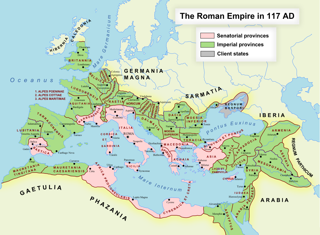
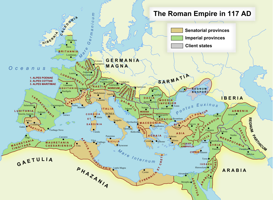
ไฟล, romanempire, ไฟล, ประว, ไฟล, หน, าท, ภาพน, การใช, ไฟล, ามโครงการ, อม, ลเก, ยวก, บภาพขนาดของต, วอย, าง, ของไฟล, กเซล, ความละเอ, ยดอ, กเซล, กเซล, กเซล, กเซล, กเซล, ภาพท, ความละเอ, ยดส, งกว, 8206, ไฟล, กเซล, ขนาดไฟล, โลไบต, ปภาพหร, อไฟล, เส, ยงน, นฉบ, บอย, ค. ifl prawtiifl hnathimiphaphni karichiflkhamokhrngkar khxmulekiywkbphaphkhnadkhxngtwxyang PNG nikhxngifl SVG ni 512 376 phikesl khwamlaexiydxun 320 235 phikesl 640 470 phikesl 1 024 752 phikesl 1 280 940 phikesl 2 560 1 880 phikesl duphaphthimikhwamlaexiydsungkwa 8206 ifl SVG 512 376 phikesl khnadifl 704 kiolibt rupphaphhruxiflesiyngni tnchbbxyuthi khxmmxns raylaexiyddanlang epnkhxkhwamthiaesdngphlcak ifltnchbbinkhxmmxns khxmmxnsepnewbistinokhrngkarsahrbekbrwbrwmsuxesri thi khunsamarthchwyid Datasource reference to visualized facts is not provided for the data that is visualized in this self made work khwamyx khaxthibayRomanEmpire 117 svg English The maximum extent of the Roman Empire Superimposed on a physical map nbsp Senatorial Provinces nbsp Imperial Provinces nbsp Client States Espanol Maxima extension del Imperio Romano Superpuesto en un mapa fisico nbsp Provincias Senatoriales nbsp Provincias Imperiales nbsp Estados satelite Deutsch Das Romische Reich zur Zeit seiner maximalen Ausdehnung unter Trajan 117 n Chr nbsp Senatorische Provinz nbsp Kaiserliche Provinz nbsp Klientelkonigtum Latina Extentum maximum de Imperium Romanum nbsp Provinciae senatus nbsp Provinciae Imperii nbsp Civitates Clientes 中文 公元117年图拉真在位时期罗马帝国的最大疆域 nbsp 元老院行省 nbsp 元首行省 nbsp 附庸国 日本語 ローマ帝国の最大版図 西暦117年 皇帝トラヤヌス nbsp 元老院属州 nbsp 皇帝属州 nbsp 従属国 wnthi 17 tulakhm ph s 2548 first version 19 thnwakhm ph s 2550 last version aehlngthima naekhacak en wikipedia mayngkhxmmxns phusrangsrrkh ArdadN thi wikiphiediyphasaxngkvs karxnuyat karichiflniihm Public Domain ewxrchnxun aekikh catala Deutsch English 1 English 2 English 3 espanol magyar italiano Nederlands portugues ukrayinska slovenscina Turkce 中文 Ἀrxaia ἑllhnikὴ euskara SVG nbsp genesisInfoField nbsp sxrsokhdkhxng SVG nitrwcsxbthuktxngaelw nbsp iflphaphkrafiksewketxrni srangkhunodyich nbsp Inkscape SVG Support This document is in the Scalable Vector Graphic format SVG and requires a supported browser Firefox Google Chrome Opera or a SVG plugin for Internet Explorer and other browsers SVG is an open text based format which means this map can be downloaded and modified translated completely using a vector graphics editor like Adobe Illustrator or Inkscape free or a text editor such as Notepad BLANK THUMBNAIL View large PNG View medium PNG SVG Plugin for Internet Explorer and other browsers Click here purge cache and then CTRL F5 to reload Help Try 1 Try 2 Try 1 Try 2 Adobe SVG plugin Recommended browser More Help Firefox List of SVG tools karxnuyatichsiththi ArdadN thi wikiphiediyphasaxngkvs inthanaphuthuxlikhsiththikhxngphaphhruxsuxni xnuyatihichphaphhruxsuxniphayitenguxnikhtxipni Public domain Public domain false false khapheca phuthuxlikhsiththiinnganni khxmxbnganihepnsatharnsmbti prakasnimiphlthwolkinbangpraeths karkrathadngklawxacimsamarththaidtamkdhmaykhaphecaxnuyatihthukkhnmisiththiinkarichiflniinthukehtuphlkarich odyimmimienguxnikh ewnaetkdhmayimxnuyatihthaechnnnkhabrryayodyyxithyephimkhabrryaythrrthdediywephuxkhyaykhwamwaiflnimixairxngkvsMap of the maximum extent of the Roman EmpiresepnMapa de la extension maxima del Imperio Romanocin罗马帝国的最大疆域的地图eyxrmnKarte des Romische Reich zur Zeit seiner maximalen AusdehnunglatinExtentum maximum de Imperium Romanumyipunローマ帝国の最大版図ixethmthiaesdngxyuiniflniprakxbdwysthanalikhsiththicopyrighted dedicated to the public domain by copyright holder nbsp xngkvssyyaxnuyatreleased into the public domain by the copyright holder nbsp xngkvswnthisrang wnkxtng17 tulakhm 2007media type nbsp xngkvsimage svg xml prawtiifl khlikwnthi ewlaephuxduiflthipraktinkhnann lasud ekasud du ihmkwa 10 ekakwa 10 10 20 50 100 250 500 wnthi ewlarupyxkhnadphuichkhwamehn pccubn18 48 24 phvscikayn 2565512 376 704 kiolibt Vikarnaalpes poeniae alpes poeninae 09 36 2 knyayn 2564512 376 696 kiolibt OgreBot BOT Reverting to most recent version before archival 09 36 2 knyayn 25642 180 1 600 1 96 emkaibt OgreBot BOT Uploading old version of file from en wikipedia originally uploaded on 2008 12 10 00 59 00 by Andrein 09 36 2 knyayn 25642 180 1 600 1 96 emkaibt OgreBot BOT Uploading old version of file from en wikipedia originally uploaded on 2008 12 10 00 54 46 by Andrein 09 36 2 knyayn 25642 180 1 600 1 96 emkaibt OgreBot BOT Uploading old version of file from en wikipedia originally uploaded on 2008 12 10 00 22 12 by Andrein 09 36 2 knyayn 25642 180 1 600 1 94 emkaibt OgreBot BOT Uploading old version of file from en wikipedia originally uploaded on 2008 12 09 20 41 09 by Andrein 09 36 2 knyayn 25642 180 1 600 639 kiolibt OgreBot BOT Uploading old version of file from en wikipedia originally uploaded on 2008 09 18 15 26 52 by Andrein 09 35 2 knyayn 25642 180 1 600 639 kiolibt OgreBot BOT Uploading old version of file from en wikipedia originally uploaded on 2008 08 28 12 12 21 by Andrein 09 17 2 singhakhm 2562512 376 696 kiolibt Vikarnathere was a dot out of the map 06 13 31 singhakhm 25612 180 1 600 1 11 emkaibt Begoon lasud ekasud du ihmkwa 10 ekakwa 10 10 20 50 100 250 500 hnathimiphaphni hnatxipni oyngmathiphaphni kllixanarobenngsis kllixaxakwitanixa kllixaaeblkika ckrwrrdiormntawntk sieriy mnthlkhxngormn brietnsmyormn phnoneniy mnthlkhxngormn lusitanixa xaekhiy mnthlkhxngormn xlepskxttiix xlepspxyniin xlepsmaritiim xarabixaaepitrxa xitalismyormn xiiphrs phumiphakh xiyiptsmyormn hispanixa hispanixatarraokenngsis hispanixaibtika aekrmanixasuaeprixxr aekrmanixaxingaefrixxr aexfrika mnthlkhxngormn olktawntk aemaebb mnthlormn kh s 120 karichiflkhamokhrngkar wikixuntxipniichiflni karichbn af wikipedia org Gallia Narbonensis Gallia Belgica Sjabloon Romeinse provinsies 117 n C Gallia Aquitania Germania Inferior Germania Superior Thracie Kappadosie Lusitania Romeinse provinsie Koninkryk Iberie Epirus Osroene Wikipedia Geselshoekie Taalforum Britannia provinsie Dalmasie Numidie Achaea Romeinse provinsie Aegyptus Romeinse provinsie Africa Romeinse provinsie Alpes Cottiae Alpes Maritimae Alpes Poenninae Arabia Petraea Armenia Inferior Asia Romeinse provinsie Assyria Romeinse provinsie Bithynia Romeinse provinsie Cilicia Commagene Corsica et Sardinia Creta et Cyrenaica Dacia Romeinse provinsie Galatia Romeinse provinsie Gallia Lugdunensis Hispania Baetica Hispania Tarraconensis Italia Romeinse Ryk Iudaea Romeinse provinsie Lycaonia Lycia et Pamphylia Macedonia Romeinse provinsie Mauretania Caesariensis Mauretania Tingitana Moesia Superior Noricum Pannonia Pamphylia Pisidia Raetia Sicilia Romeinse provinsie dukarichkhamokhrngkarephimetimkhxngiflnikhxmulekiywkbphaph phaphnimikhxmulephimetim sungswnihymacakklxngdicitxlhruxsaeknenxrthisamarthekbkhxmuldngklawiwrwmkbphaphid thaphaphnithukprbprungaekikhhruxepliynaeplngcakedim khxmulbangxyangcayngkhngimepliynaeplngehmuxnphaphthithukprbprungaekikhnnkhwamkwang100 khwamsung100 ekhathungcak https th wikipedia org wiki ifl RomanEmpire 117 svg, wikipedia, วิกิ หนังสือ, หนังสือ, ห้องสมุด,