คำอธิบายSatellite image of Bangladesh in October 2001.jpg
Satellite image of Bangladesh in October 2001
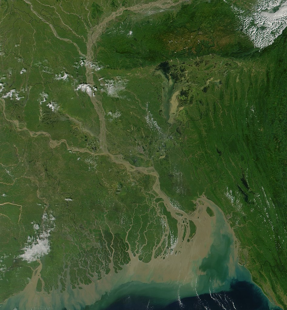
True-color MODIS image from October 23, 2001.
Lush with vegetation to the south, numerous rivers, brown with churned up sediment, flow into the valley of the Brahmaputra River in Assam, India. The Brahmaputra turns southward at the border of Bangladesh and is soon joined by the Ganges River, flowing in from image left. The mighty river splits into numerous channels as it runs out toward the Bay of Bengal, giving the region the name "Mouths of the Ganges." Vast amounts of sediment are being emptied into the Bay by the river, and greenish blue swirls could be a mixture of sediment and phytoplankton.
วันที่
แหล่งที่มา
Cropped from Visible Earth
ผู้สร้างสรรค์
Jacques Descloitres, MODIS Land Rapid Response Team, NASA/GSFC
{{PD-USGov-NASA}} Satellite image of Bangladesh in October 2001. Original image taken from NASA's Visible Earth http://visibleearth.nasa.gov/cgi-bin/viewrecord?10722
ไฟล, satellite, image, bangladesh, october, 2001, ไฟล, ประว, ไฟล, หน, าท, ภาพน, การใช, ไฟล, วนกลาง, อม, ลเก, ยวก, บภาพขนาดของต, วอย, างน, กเซล, ความละเอ, ยดอ, กเซล, กเซล, กเซล, กเซล, กเซล, ภาพท, ความละเอ, ยดส, งกว, 8206, กเซล, ขนาดไฟล, โลไบต, ชน, ดไมม, image, . ifl prawtiifl hnathimiphaphni karichiflswnklang khxmulekiywkbphaphkhnadkhxngtwxyangni 554 599 phikesl khwamlaexiydxun 222 240 phikesl 444 480 phikesl 710 768 phikesl 947 1 024 phikesl 2 214 2 394 phikesl duphaphthimikhwamlaexiydsungkwa 8206 2 214 2 394 phikesl khnadifl 674 kiolibt chnidimm image jpeg rupphaphhruxiflesiyngni tnchbbxyuthi khxmmxns raylaexiyddanlang epnkhxkhwamthiaesdngphlcak ifltnchbbinkhxmmxns khxmmxnsepnewbistinokhrngkarsahrbekbrwbrwmsuxesri thi khunsamarthchwyid khaxthibaySatellite image of Bangladesh in October 2001 jpg Satellite image of Bangladesh in October 2001True color MODIS image from October 23 2001 Lush with vegetation to the south numerous rivers brown with churned up sediment flow into the valley of the Brahmaputra River in Assam India The Brahmaputra turns southward at the border of Bangladesh and is soon joined by the Ganges River flowing in from image left The mighty river splits into numerous channels as it runs out toward the Bay of Bengal giving the region the name Mouths of the Ganges Vast amounts of sediment are being emptied into the Bay by the river and greenish blue swirls could be a mixture of sediment and phytoplankton wnthi 23 tulakhm ph s 2544aehlngthima Cropped from Visible Earthphusrangsrrkh Jacques Descloitres MODIS Land Rapid Response Team NASA GSFC Public domain Public domain false falsephaphniepnsatharnsmbti enuxngcakepnphaphthisrangkhunodyxngkhkarbriharkarbinaelaxwkasaehngchati NASA sungtamnoybaydanlikhsiththikhxngnasarabuiwwa phaphaelasuxtang khxngnasaimidrbkarkhumkhrxngodylikhsiththiykewncarabuiwwamilikhsiththi duephimthi hnanoybaydanlikhsiththikhxngnasa hrux noybaykarichphaphkhxng JPLkhaetuxn karich olokkhxngnasa ekhruxnghmayaelaekhruxngpradbkhxngnasa thukcakddwykdhmayshrthxemrikainlksna 14 khxngkhxbngkhbthangrachkarshrthxemrika swnthi 1221 ewbistkhxngnasaekbrwbrwmphaphthimacakxngkhkarxwkasosewiyt xngkhkarxwkasaehngchatirsesiy aelaxngkhkarxwkasthimiichxngkhkarxwkaskhxngshrthxemrika epncanwnmak phaphehlaniimcaepntxngepnsatharnsmbtiesmxip phaphhruxsuxthimacak klxngothrthrrsnxwkashbebil xacmilikhsiththi hakphaphhruxsuxnnimidrabuchdecnwamacak sthabnwithyasastrklxngothrthrrsnxwkas 1 phaphhruxsuxthnghmdthimacakekhruxngmuxkhxng okhrngkarsuksadwngxathityaelalmsuriya milikhsiththi karnaphaphhruxsuxcakokhrngkaripichnxkehnuxcakkarichephuxkarkhahruxephuxkarsuksa txngidrbxnuyatkxn 2 phaphthithukkhdeluxkihepn phaphdarasastrpracawn APOD bnewbistkhxng APOD xacmilikhsiththi 3 khabrryayodyyxithyephimkhabrryaythrrthdediywephuxkhyaykhwamwaiflnimixairixethmthiaesdngxyuiniflniprakxbdwywnthisrang wnkxtng23 tulakhm 2001 prawtiifl khlikwnthi ewlaephuxduiflthipraktinkhnann wnthi ewlarupyxkhnadphuichkhwamehn pccubn22 38 18 thnwakhm 25472 214 2 394 674 kiolibt Hautala PD USGov NASA Satellite image of Bangladesh in October 2001 Original image taken from NASA 039 s Visible Earth http visibleearth nasa gov cgi bin viewrecord 10722 hnathimiphaphni hnatxipni oyngmathiphaphni praethsbngklaeths karichiflswnklang wikixuntxipniichiflni karichbn af wikipedia org Bangladesj karichbn ar wikipedia org بنغلاديش karichbn ast wikipedia org Dhaka karichbn as wikipedia org ব ল দ শ karichbn ba wikipedia org Bangladesh karichbn be tarask wikipedia org Banglyadesh karichbn bg wikipedia org Geografiya na Bangladesh karichbn bm wikipedia org Bangladesh karichbn bn wikipedia org ব ল দ শ ব ল দ শ র ভ গ ল ব ল দ শ র র পর খ karichbn bs wikipedia org Banglades karichbn ca wikipedia org Dacca karichbn cs wikipedia org Banglades karichbn de wikipedia org Meghna karichbn en wikipedia org Outline of Bangladesh Eastern South Asia User talk Vsmith Archive27 karichbn en wikiquote org Bangladesh karichbn es wikipedia org Banglades Daca karichbn fi wikipedia org Bangladesh karichbn frr wikipedia org Meghna karichbn hu wiktionary org Banglades karichbn id wikipedia org Bangladesh Geografi Bangladesh karichbn it wikipedia org Bangladesh Portale Bangladesh Portale Bangladesh Geografia Meghna fiume Geografia del Bangladesh karichbn jv wikipedia org Banggaladesa karichbn lt wikipedia org Bangladesas karichbn new wikipedia org ब गल द श ख ल ब ल ब गल द श ब गल द शय भ ग ल karichbn nl wikipedia org Meghna karichbn no wikipedia org Bangladesh karichbn pl wikipedia org Geografia Bangladeszu karichbn pt wikipedia org Bangladesh Daca Usuario DAR7 Testes Geografia Bangladesh karichbn roa tara wikipedia org Bangladesh karichbn ru wikipedia org Bangladesh karichbn sh wikipedia org Banglades karichbn sr wikipedia org Bangladesh karichbn ta wikipedia org வங க ளத ச ப வ ய யல karichbn te wikipedia org బ గ ల ద శ karichbn tg wikipedia org Banglodesh karichbn uk wikipedia org Geografiya Bangladesh dukarichthwolkephimetimkhxngiflnikhxmulekiywkbphaph phaphnimikhxmulephimetim sungswnihymacakklxngdicitxlhruxsaeknenxrthisamarthekbkhxmuldngklawiwrwmkbphaphid thaphaphnithukprbprungaekikhhruxepliynaeplngcakedim khxmulbangxyangcayngkhngimepliynaeplngehmuxnphaphthithukprbprungaekikhnn error0 ekhathungcak https th wikipedia org wiki ifl Satellite image of Bangladesh in October 2001 jpg, wikipedia, วิกิ หนังสือ, หนังสือ, ห้องสมุด,