fbpx
วิกิพีเดีย

South Asia (orthographic projection) without national boundaries

ดูภาพที่มีความละเอียดสูงกว่า((ไฟล์ SVG, 550 × 550 พิกเซล, ขนาดไฟล์: 2.8 เมกะไบต์))

รูปภาพหรือไฟล์เสียงนี้ ต้นฉบับอยู่ที่ คอมมอนส์ รายละเอียดด้านล่าง เป็นข้อความที่แสดงผลจาก ไฟล์ต้นฉบับในคอมมอนส์
คอมมอนส์เป็นเว็บไซต์ในโครงการสำหรับเก็บรวบรวมสื่อเสรี ที่ คุณสามารถช่วยได้

ความย่อ

คำอธิบาย
English: South Asia
วันที่ (UTC)
แหล่งที่มา
  • India (orthographic projection).svg
ผู้สร้างสรรค์ user:Serg!o
เวอร์ชันอื่น
This is a Grey & green orthographic projection map.
  • More information here.
العربية: الرجاء، قراءة الميثاق.
বাংলা: দয়া করে, রীতিনীতিটি পড়ুন।
Deutsch: Bitte lies die Konventionen.
English: Please, read the conventions.
Español: Por favor, lea las convenciones.
Filipino: Paki-basa ang mga kumbensyon.
Français : S'il vous plaît, lisez les conventions.
हिन्दी: कृपया सभागमों को पढ़ लें.
Bahasa Indonesia: Silakan, baca konvensi.
Italiano: Si prega di leggere le convenzioni.
日本語: 規約をご確認ください。
ქართული: გთხოვთ, გაეცნოთ კონვენციებს.
Македонски: Ве молиме, прочитајте ги општоприфатените правила.
Português: Por favor, leia as convenções.
Русский: Пожалуйста, прочитайте соглашения.
Tagalog: Paki-basa ang mga kumbensyon.
Українська: Будь ласка, прочитайте конвенції.
Tiếng Việt: Hãy đọc công văn trước khi đăng.
World maps

Africa

हिन्दी: अफ्रीका
ქართული: აფრიკა.

Eastern Africa

हिन्दी: पूर्वी अफ्रीका

Southern Africa

Central Africa

Northern Africa

Western Africa

Americas

ქართული: ამერიკა.
हिन्दी: अमेरिका

North America

हिन्दी: उत्तरी अमेरिका

Central America

Caribbean

South America

हिन्दी: दक्षिण अमेरिका

Asia

हिन्दी: एशिया (जम्भूद्वीप)
ქართული: აზია.
Português: Ásia.
Українська: Азія.

East

हिन्दी: पूर्वी एशिया
ქართული: აღმოსავლეთი აზია.
Português: Ásia Oriental.
Українська: Східна Азія.

Central

हिन्दी: मध्य एशिया
ქართული: ცენტრალური აზია.
Português: Ásia Central.
Українська: Центральна Азія.

Southeast

Filipino: Timog-silangang Asya.
हिन्दी: दक्षिण-पूर्वी एशिया
Bahasa Indonesia: Asia tenggara
ქართული: სამხრეთ-აღმოსავლეთი აზია.
Português: Sudeste Asiático.
Tagalog: Timog-silangang Asya.
Українська: Південно-Східна Азія.

South

हिन्दी: दक्षिण एशिया
(भारतीय उपमहाद्वीप)
ქართული: სამხრეთი აზია.
Português: Sul da Ásia.
Українська: Південна Азія.
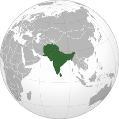
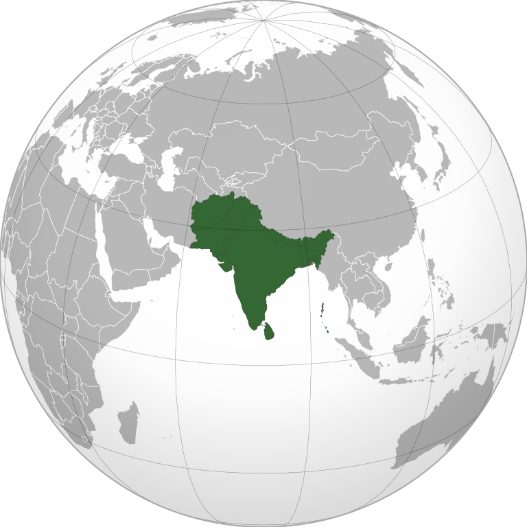
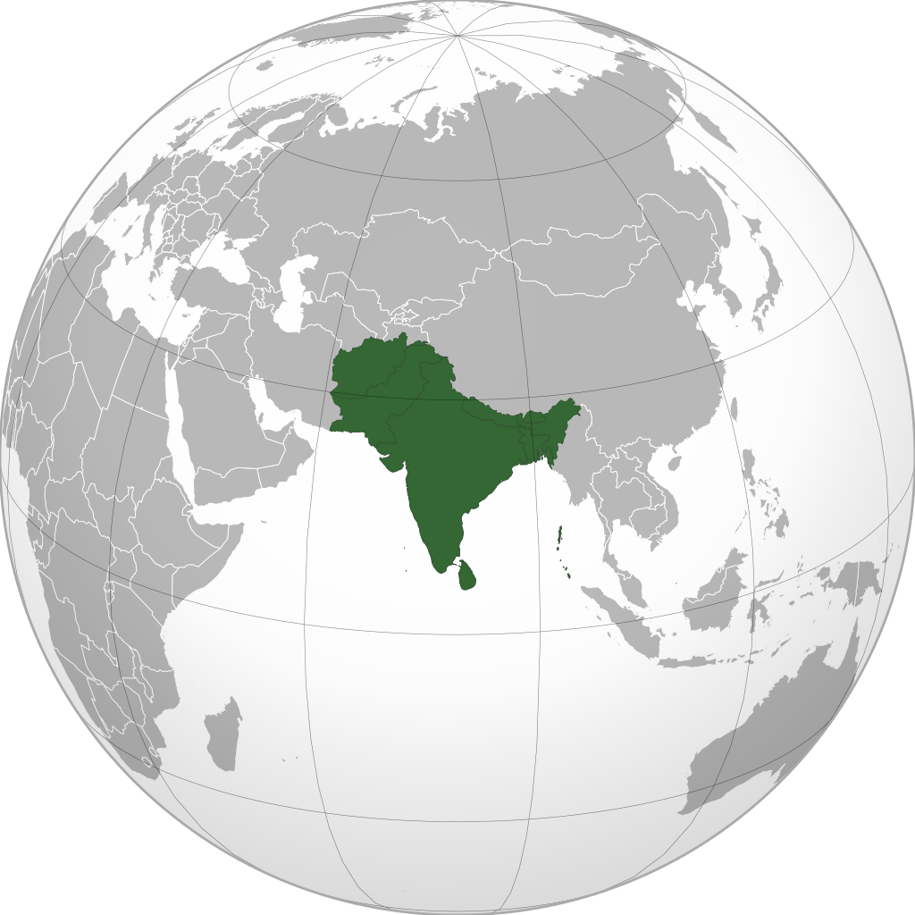
Western

हिन्दी: पश्चिमी एशिया
ქართული: დასავლეთ აზია.
Português: Sudoeste da Ásia.
Українська: Передня Азія.

Europe

हिन्दी: यूरोप
ქართული: ევროპა.
Português: Europa.
Română: Europa.
Русский: Европа.
Українська: Європа.

Countries

Oceania

हिन्दी: ओशिआनिया
ქართული: ოკეანეთი.
Português: Oceania.
Українська: Океанія.

Intercontinental

हिन्दी: अंतर्महाद्वीपिय
ქართული: კონტინენთშორისი.
Português: Intercontinental.
Українська: Міжконтинентальні.

Historical

English: Unions, Organizations, Kingdoms, Empires
Español: Uniones, Organizaciones, Reinos, Imperios
Filipino: Mga Unyon, Organisasyon, Kaharian, Imperyo
Français : Unions, Organisations, Royaumes, Empires
हिन्दी: संघ, संगठन, राज्य, साम्राज्य व ऐतिहासिक देश
ქართული: გაერთიანებები, ორგანიზაციები, სამეფოები, იმპერიები
Português: Estados extintos.
Tagalog: Mga Unyon, Organisasyon, Kaharian, Imperyo
Українська: Союзи, Організації, Королівства, Імперії

Subnationals

हिन्दी: उपराष्ट्रीय इकाईयाँ
ქართული: სუბეროვნული ერთეულები.
Português: Entidades subnacionais.
Українська: Субнаціональні утворення.
SVG genesis
InfoField
 
ซอร์สโค้ดของ SVG นี้ตรวจสอบถูกต้องแล้ว
 
ไฟล์ภาพกราฟิกส์เวกเตอร์นี้ สร้างขึ้นโดยใช้ Inkscape, or with something else.
ภาพนี้ ได้รับการปรับแต่งภาพ ซึ่งหมายความว่าจะได้รับการเปลี่ยนแปลงภาพต่างจากต้นฉบับ ต้นฉบับสามารถดูได้ที่นี่: India (orthographic projection).svg. ปรับแต่งภาพโดย Serg!o.

การอนุญาตใช้สิทธิ

ข้าพเจ้า ในฐานะผู้ถือลิขสิทธิ์ของภาพหรือสื่อนี้ อนุญาตให้ใช้ภาพหรือสื่อนี้ภายใต้เงื่อนไขต่อไปนี้

ไฟล์นี้อยู่ภายใต้สัญญาอนุญาต ครีเอทีฟคอมมอนส์ แบบแสดงที่มา-อนุญาตแบบเดียวกัน 3.0 ต้นฉบับ
คุณสามารถ:
  • ที่จะแบ่งปัน – ที่จะทำสำเนา แจกจ่าย และส่งงานดังกล่าวต่อไป
  • ที่จะเรียบเรียงใหม่ – ที่จะดัดแปลงงานดังกล่าว
ภายใต้เงื่อนไขต่อไปนี้:
  • แสดงที่มา – คุณต้องให้เกียรติเจ้าของงานอย่างเหมาะสม โดยเพิ่มลิงก์ไปยังสัญญาอนุญาต และระบุหากมีการเปลี่ยนแปลง คุณอาจทำเช่นนี้ได้ในรูปแบบใดก็ได้ตามควร แต่ต้องไม่ใช่ในลักษณะที่แนะว่าผู้ให้อนุญาตสนับสนุนคุณหรือการใช้งานของคุณ
  • อนุญาตแบบเดียวกัน – หากคุณดัดแปลง เปลี่ยนรูป หรือต่อเติมงานนี้ คุณต้องใช้สัญญาอนุญาตแบบเดียวกันหรือแบบที่เหมือนกับสัญญาอนุญาตที่ใช้กับงานนี้เท่านั้น
อนุญาตให้คัดลอก แจกจ่ายและ/หรือดัดแปรเอกสารนี้ภายใต้เงื่อนไขของสัญญาอนุญาตเอกสารเสรีของกนู รุ่น 1.2 หรือรุ่นใด ๆ นับจากนี้ที่ออกโดยมูลนิธิซอฟต์แวร์เสรี โดยไม่มีส่วนใดห้ามแก้ไข ไม่มีข้อความปกหน้าและปกหลัง สำเนาของสัญญาอนุญาตรวมอยู่ในส่วนชื่อ สัญญาอนุญาตเอกสารเสรีของกนู
คุณสามารถเลือกสัญญาอนุญาตดังกล่าวตามต้องการ
The map has been created with the Generic Mapping Tools: https://www.generic-mapping-tools.org/ using one or more of these public-domain datasets for the relief:

বাংলা  English  español  français  italiano  日本語  македонски  sicilianu  中文(简体)  中文(繁體)  +/−

อนุญาตให้คัดลอก แจกจ่ายและ/หรือดัดแปรเอกสารนี้ภายใต้เงื่อนไขของสัญญาอนุญาตเอกสารเสรีของกนู รุ่น 1.2 หรือรุ่นใด ๆ นับจากนี้ที่ออกโดยมูลนิธิซอฟต์แวร์เสรี โดยไม่มีส่วนใดห้ามแก้ไข ไม่มีข้อความปกหน้าและปกหลัง สำเนาของสัญญาอนุญาตรวมอยู่ในส่วนชื่อ สัญญาอนุญาตเอกสารเสรีของกนู

คำบรรยายโดยย่อ

เพิ่มคำบรรยายทรรทัดเดียวเพื่อขยายความว่าไฟล์นี้มีอะไร
South Asia (orthographic projection) without national boundaries

ไอเทมที่แสดงอยู่ในไฟล์นี้

ประกอบด้วย

รัฐอุตตรประเทศ

อักไสชิน

สถานะลิขสิทธิ์

มีลิขสิทธิ์

สัญญาอนุญาต

Creative Commons Attribution-ShareAlike 3.0 Unported อังกฤษ

GNU Free Documentation License, version 1.2 or later อังกฤษ

MIME type อังกฤษ

image/svg+xml

ประวัติไฟล์

คลิกวันที่/เวลาเพื่อดูไฟล์ที่ปรากฏในขณะนั้น

(ล่าสุด | เก่าสุด) ดู (ใหม่กว่า 10 | เก่ากว่า 10) (10 | 20 | 50 | 100 | 250 | 500)
วันที่/เวลารูปย่อขนาดผู้ใช้ความเห็น
ปัจจุบัน13:10, 12 พฤศจิกายน 2565550 × 550 (2.8 เมกะไบต์)Sourav BapuliAdded Siachen Glacier as requested by {{u|King Prithviraj II}}
00:56, 2 มกราคม 2564553 × 553 (216 กิโลไบต์)Sbb1413Converted to Plain SVG.
00:52, 2 มกราคม 2564553 × 553 (216 กิโลไบต์)Sbb1413The previous attempt failed, another attempt of correcting the errors.
00:48, 2 มกราคม 2564553 × 553 (179 กิโลไบต์)Sbb1413Corrected W3C error.
23:23, 24 สิงหาคม 2563553 × 553 (284 กิโลไบต์)ProsfilaesReverted to version as of 01:09, 24 August 2020 (UTC); consistency with historical use of this file. Upload distinct new versions to a new name
19:12, 24 สิงหาคม 2563744 × 1,052 (540 กิโลไบต์)Xerxes1985Reverted to version as of 19:21, 22 August 2020 (UTC) It isn’t meant to be the important feature, it’s portrayed in a lighter colour due to its position as a link between south and Central Asia, or do you think Afghanistan has the same position in South Asia as Bangladesh, Pakistan or India ?
08:09, 24 สิงหาคม 2563553 × 553 (284 กิโลไบต์)Aditya KabirReverted to version as of 20:10, 21 August 2020 (UTC) The South Asian map doesn't need Afghanistan as the most important feature
02:21, 23 สิงหาคม 2563744 × 1,052 (540 กิโลไบต์)Xerxes1985Reverted to version as of 20:10, 19 August 2020 (UTC) Thats why it’s still in the map and not completely removed
03:10, 22 สิงหาคม 2563553 × 553 (284 กิโลไบต์)PersianVReverted to version as of 18:07, 11 May 2017 (UTC) Reverted, technically considered South Asian
03:10, 20 สิงหาคม 2563744 × 1,052 (540 กิโลไบต์)Xerxes1985Afghanistan in a lighter colour
(ล่าสุด | เก่าสุด) ดู (ใหม่กว่า 10 | เก่ากว่า 10) (10 | 20 | 50 | 100 | 250 | 500)

การใช้ไฟล์ส่วนกลาง

วิกิอื่นต่อไปนี้ใช้ไฟล์นี้:

  • قائمة مفاتيح الاتصال الدولية
  • Asociación Sudasiática pa la Cooperación Rexonal
  • Mal:Asia Kelod
  • Көньяҡ Азия
  • दक्खिन एशियाई क्षेत्रीय सहजोग संगठन
  • Bhutan
  • Hindia
  • Maladewa
  • Nepal
  • Pakistan
  • Citakan:Asia Salatan
  • ভারত
  • পাকিস্তান
  • নেপাল
  • মালদ্বীপ
  • আফগানিস্তান
  • ভুটান
  • দক্ষিণ এশীয় আঞ্চলিক সহযোগিতা সংস্থা
  • দক্ষিণ এশিয়া
  • শ্রীলঙ্কা
  • টেমপ্লেট:দক্ষিণ এশিয়ার দেশসমূহ
  • ভারতের রাজনীতি
  • ভারতের সংস্কৃতি
  • আলাপ:নিয়াজ মোরশেদ
  • আলাপ:শ্রীলঙ্কা
  • ব্যবহারকারী:Jayantanth/Sandbox
  • ২০১২ সাফ মহিলা চ্যাম্পিয়নশিপ
  • মালদ্বীপের বৈদেশিক সম্পর্ক
  • প্রবেশদ্বার:শ্রীলঙ্কা
  • প্রবেশদ্বার:পাকিস্তান
  • প্রবেশদ্বার:নেপাল
  • প্রবেশদ্বার:পাকিস্তান/প্রবেশদ্বারসমূহ
  • প্রবেশদ্বার:নেপাল/প্রবেশদ্বারসমূহ
  • ดูการใช้ทั่วโลกเพิ่มเติมของไฟล์นี้

    ข้อมูลเกี่ยวกับภาพ

    ไฟล, south, asia, orthographic, projection, without, national, boundaries, ไฟล, ประว, ไฟล, หน, าท, ภาพน, การใช, ไฟล, วนกลาง, อม, ลเก, ยวก, บภาพขนาดของต, วอย, าง, ของไฟล, กเซล, ความละเอ, ยดอ, กเซล, กเซล, กเซล, กเซล, กเซล, ภาพท, ความละเอ, ยดส, งกว, 8206, ไฟล, กเ. ifl prawtiifl hnathimiphaphni karichiflswnklang khxmulekiywkbphaphkhnadkhxngtwxyang PNG nikhxngifl SVG ni 550 550 phikesl khwamlaexiydxun 240 240 phikesl 480 480 phikesl 768 768 phikesl 1 024 1 024 phikesl 2 048 2 048 phikesl duphaphthimikhwamlaexiydsungkwa 8206 ifl SVG 550 550 phikesl khnadifl 2 8 emkaibt rupphaphhruxiflesiyngni tnchbbxyuthi khxmmxns raylaexiyddanlang epnkhxkhwamthiaesdngphlcak ifltnchbbinkhxmmxns khxmmxnsepnewbistinokhrngkarsahrbekbrwbrwmsuxesri thi khunsamarthchwyid khwamyx khaxthibaySouth Asia orthographic projection without national boundaries svg English South Asia wnthi 11 tulakhm ph s 2552 14 38 UTC aehlngthima India orthographic projection svg phusrangsrrkh user Serg o ewxrchnxun This is a Grey amp green orthographic projection map More information here dd dd العربية الرجاء قراءة الميثاق ব ল দয কর র ত ন ত ট পড ন Deutsch Bitte lies die Konventionen English Please read the conventions Espanol Por favor lea las convenciones Filipino Paki basa ang mga kumbensyon Francais nbsp S il vous plait lisez les conventions ह न द क पय सभ गम क पढ ल Bahasa Indonesia Silakan baca konvensi Italiano Si prega di leggere le convenzioni 日本語 規約をご確認ください ქართული გთხოვთ გაეცნოთ კონვენციებს Makedonski Ve molime prochitaјte gi opshtoprifatenite pravila Portugues Por favor leia as convencoes Russkij Pozhalujsta prochitajte soglasheniya Tagalog Paki basa ang mga kumbensyon Ukrayinska Bud laska prochitajte konvenciyi Tiếng Việt Hay đọc cong văn trước khi đăng World maps Africa ह न द अफ र क ქართული აფრიკა Africa Eastern Africa ह न द प र व अफ र क Burundi Comoros Djibouti Eritrea Ethiopia Kenya Madagascar Malawi Mauritius Mayotte Mozambique Tanzania Somalia Uganda Southern Africa Lesotho South Africa Zambia Zimbabwe Central Africa Angola Cameroon Central African Republic Chad Republic of the Congo Democratic Republic of the Congo Gabon South Sudan Northern Africa Algeria Egypt Libya Morocco Morocco amp Western Sahara Sahrawri Arab Democratic Republic Sudan Tunisia Western Sahara Western Africa Azawad Benin Burkina Faso Cape Verde Cote d Ivoire Gambia Ghana Guinea Liberia Mali Mali without Azawad Mauritania Niger Nigeria Senegal Sierra Leone Americas ქართული ამერიკა ह न द अम र क Americas Northern North America North America Central America South America Southern South America North America ह न द उत तर अम र क Greenland Canada United States of America Mexico Central America Guatemala El Salvador Honduras Nicaragua Costa Rica Panama Caribbean Trinidad and Tobago Cuba Dominican Republic Haiti Jamaica South America ह न द दक ष ण अम र क Argentina Bolivia Brazil Chile Colombia Ecuador French Guiana Guyana Paraguay Peru Suriname Uruguay Venezuela excluding claimed Venezuela including claimed Asia ह न द एश य जम भ द व प ქართული აზია Portugues Asia Ukrayinska Aziya Asia orthographic projection svg frequently subject to lame edit wars over the Caucasus boundary East ह न द प र व एश य ქართული აღმოსავლეთი აზია Portugues Asia Oriental Ukrayinska Shidna Aziya East Asia China Japan Mongolia North Korea excluding claimed South Korea excluding claimed Jiangxi Taiwan Republic of China including claimed Republic of Korea including claimed Democratic People s Republic of Korea including claimed Korea Central ह न द मध य एश य ქართული ცენტრალური აზია Portugues Asia Central Ukrayinska Centralna Aziya Central Asia Kazakhstan Tajikistan Kyrgyzstan Uzbekistan Southeast Filipino Timog silangang Asya ह न द दक ष ण प र व एश य Bahasa Indonesia Asia tenggara ქართული სამხრეთ აღმოსავლეთი აზია Portugues Sudeste Asiatico Tagalog Timog silangang Asya Ukrayinska Pivdenno Shidna Aziya Southeast Asia Association of Southeast Asian Nations The Philippines and ASEAN Indonesia Malaysia Philippines Thailand South ह न द दक ष ण एश य भ रत य उपमह द व प ქართული სამხრეთი აზია Portugues Sul da Asia Ukrayinska Pivdenna Aziya South Asia Afghanistan Bangladesh Bhutan India Maldives Nepal Pakistan Sri Lanka Western ह न द पश च म एश य ქართული დასავლეთ აზია Portugues Sudoeste da Asia Ukrayinska Perednya Aziya Western Asia Levant Georgia Georgia with inset showing breakaway states Georgia with inset without breakaway states Armenia Azerbaijan Nagorno Karabakh Republic Iran Iraq Israel Jordan Saudi Arabia State of Palestine Syria Lebanon Turkey United Arab Emirates Europe ह न द य र प ქართული ევროპა Portugues Europa Romană Europa Russkij Evropa Ukrayinska Yevropa Europe Caucasus Urals boundary Europe unclear boundary somewhere in the mid Caucasus suffering from edit wars Europe Caucasus Urals boundary with state borders Northern Europe Southern Europe Western Europe Northwestern Europe Mainland Europe Latin Europe Council of Europe European Union European Union with internal borders Benelux Visegrad Group British Isles Great Britain Island of Cyprus Iberia Countries Albania Armenia Azerbaijan Belarus Belgium Bosnia and Herzegovina Bulgaria Republic of Cyprus Czech Republic Denmark Finland France Georgia Georgia with inset showing breakaway states Georgia with inset without breakaway states Germany Iceland Italy Kazakhstan Kosovo North Macedonia Montenegro Netherlands Norway Northern Cyprus Poland Portugal Romania Russia Serbia Spain Sweden Switzerland Turkey United Kingdom Oceania ह न द ओश आन य ქართული ოკეანეთი Portugues Oceania Ukrayinska Okeaniya Oceania Australia New Guinea Australia Fiji New Zealand Papua New Guinea Intercontinental ह न द अ तर मह द व प य ქართული კონტინენთშორისი Portugues Intercontinental Ukrayinska Mizhkontinentalni The Americas Afro eurasia Arctic Antarctica Kingdom of the Netherlands Organization for Security and Co operation in Europe Eurasia Eurasian Economic Union Greater Middle East Ibero America Middle East North Atlantic Treaty Organization Arab World Arab League Latin America Anglo America Franco America Hispanic America Shanghai Cooperation Organization Historical English Unions Organizations Kingdoms Empires Espanol Uniones Organizaciones Reinos Imperios Filipino Mga Unyon Organisasyon Kaharian Imperyo Francais nbsp Unions Organisations Royaumes Empires ह न द स घ स गठन र ज य स म र ज य व ऐत ह स क द श ქართული გაერთიანებები ორგანიზაციები სამეფოები იმპერიები Portugues Estados extintos Tagalog Mga Unyon Organisasyon Kaharian Imperyo Ukrayinska Soyuzi Organizaciyi Korolivstva Imperiyi Almoravid Empire Austro Hungary Aztec Empire Aztec Empire with dominance between Teozapotlan and Xoconochco Biafra Benin Separatist state in Nigeria Captaincy General of Chile Chincha Country Confederate States of America Dominion of Pakistan with Indian Controlled Kashmir Eurasian Economic Community European Economic Community Empire of Brazil Federal Republic of Central America First Mexican Empire Frankish Empire German Reich German Reich With Occupations Great Colombia Granadine Confederation Italian Empire Japanese Empire Inca Empire Mughal Empire New France New Granada Peru Bolivia Confederation Roman Empire Russian Empire Second Mexican Empire Songhai Empire Union of Soviet Socialist Republics United Arab Republic United Provinces of Central America United States of Colombia Viceroyalty of New Granada Viceroyalty of New Spain Viceroyalty of Peru Viceroyalty of the Rio de la Plata Wilsonian Armenia Subnationals ह न द उपर ष ट र य इक ईय ქართული სუბეროვნული ერთეულები Portugues Entidades subnacionais Ukrayinska Subnacionalni utvorennya Canary Islands Spain Catalan Countries French Guiana Greenland Quebec Canada Puerto Rico U S Great Britain Dagestan Federal subject of Russia SVG nbsp genesisInfoField nbsp sxrsokhdkhxng SVG nitrwcsxbthuktxngaelw nbsp iflphaphkrafiksewketxrni srangkhunodyich nbsp Inkscape or with something else phaphni idrbkarprbaetngphaph sunghmaykhwamwacaidrbkarepliynaeplngphaphtangcaktnchbb tnchbbsamarthduidthini India orthographic projection svg prbaetngphaphody Serg o nbsp karxnuyatichsiththi khapheca inthanaphuthuxlikhsiththikhxngphaphhruxsuxni xnuyatihichphaphhruxsuxniphayitenguxnikhtxipniiflnixyuphayitsyyaxnuyat khriexthifkhxmmxns aebbaesdngthima xnuyataebbediywkn 3 0 tnchbbkhunsamarth thicaaebngpn thicathasaena aeckcay aelasngngandngklawtxip thicaeriyberiyngihm thicaddaeplngngandngklaw phayitenguxnikhtxipni aesdngthima khuntxngihekiyrtiecakhxngnganxyangehmaasm odyephimlingkipyngsyyaxnuyat aelarabuhakmikarepliynaeplng khunxacthaechnniidinrupaebbidkidtamkhwr aettxngimichinlksnathiaenawaphuihxnuyatsnbsnunkhunhruxkarichngankhxngkhun xnuyataebbediywkn hakkhunddaeplng epliynrup hruxtxetimnganni khuntxngichsyyaxnuyataebbediywknhruxaebbthiehmuxnkbsyyaxnuyatthiichkbnganniethannhttps creativecommons org licenses by sa 3 0 CC BY SA 3 0 Creative Commons Attribution Share Alike 3 0 true true xnuyatihkhdlxk aeckcayaela hruxddaeprexksarniphayitenguxnikhkhxngsyyaxnuyatexksaresrikhxngknu run 1 2 hruxrunid nbcaknithixxkodymulnithisxftaewresri odyimmiswnidhamaekikh immikhxkhwampkhnaaelapkhlng saenakhxngsyyaxnuyatrwmxyuinswnchux syyaxnuyatexksaresrikhxngknuhttp www gnu org copyleft fdl html GFDL GNU Free Documentation License true true xnuyatihkhdlxk aeckcayaela hruxddaeprexksarniphayitenguxnikhkhxngsyyaxnuyatexksaresrikhxngknu run 1 2 hruxrunid nbcaknithixxkodymulnithisxftaewresri odyimmiswnidhamaekikh immikhxkhwampkhnaaelapkhlng saenakhxngsyyaxnuyatrwmxyuinswnchux syyaxnuyatexksaresrikhxngknuhttp www gnu org copyleft fdl html GFDL GNU Free Documentation License true truekhunsamartheluxksyyaxnuyatdngklawtamtxngkar The map has been created with the Generic Mapping Tools https www generic mapping tools org using one or more of these public domain datasets for the relief ETOPO2 topography bathymetry http www ngdc noaa gov mgg global global html GLOBE topography http www ngdc noaa gov mgg topo gltiles html SRTM topography http www2 jpl nasa gov srtm ব ল nbsp English nbsp espanol nbsp francais nbsp italiano nbsp 日本語 nbsp makedonski nbsp sicilianu nbsp 中文 简体 nbsp 中文 繁體 nbsp xnuyatihkhdlxk aeckcayaela hruxddaeprexksarniphayitenguxnikhkhxngsyyaxnuyatexksaresrikhxngknu run 1 2 hruxrunid nbcaknithixxkodymulnithisxftaewresri odyimmiswnidhamaekikh immikhxkhwampkhnaaelapkhlng saenakhxngsyyaxnuyatrwmxyuinswnchux syyaxnuyatexksaresrikhxngknuhttp www gnu org copyleft fdl html GFDL GNU Free Documentation License true truekhabrryayodyyxithyephimkhabrryaythrrthdediywephuxkhyaykhwamwaiflnimixairxngkvsSouth Asia orthographic projection without national boundarieshindiदक ष ण एश य thmilத ச ய எல ல கள இல ல த த ற க ச ய ஆர த த க ர ஃப க ப ர ஜ க ஷன cxreciyსამხრეთ აზია ორთოგრაფიული პროექცია ნაციონალური საზღვრების გარეშეixethmthiaesdngxyuiniflniprakxbdwyrthxuttrpraethsxkischinsthanalikhsiththimilikhsiththisyyaxnuyatCreative Commons Attribution ShareAlike 3 0 Unported nbsp xngkvsGNU Free Documentation License version 1 2 or later nbsp xngkvsMIME type nbsp xngkvsimage svg xml prawtiifl khlikwnthi ewlaephuxduiflthipraktinkhnann lasud ekasud du ihmkwa 10 ekakwa 10 10 20 50 100 250 500 wnthi ewlarupyxkhnadphuichkhwamehn pccubn13 10 12 phvscikayn 2565550 550 2 8 emkaibt Sourav BapuliAdded Siachen Glacier as requested by u King Prithviraj II 00 56 2 mkrakhm 2564553 553 216 kiolibt Sbb1413Converted to Plain SVG 00 52 2 mkrakhm 2564553 553 216 kiolibt Sbb1413The previous attempt failed another attempt of correcting the errors 00 48 2 mkrakhm 2564553 553 179 kiolibt Sbb1413Corrected W3C error 23 23 24 singhakhm 2563553 553 284 kiolibt ProsfilaesReverted to version as of 01 09 24 August 2020 UTC consistency with historical use of this file Upload distinct new versions to a new name 19 12 24 singhakhm 2563744 1 052 540 kiolibt Xerxes1985Reverted to version as of 19 21 22 August 2020 UTC It isn t meant to be the important feature it s portrayed in a lighter colour due to its position as a link between south and Central Asia or do you think Afghanistan has the same position in South Asia as Bangladesh Pakistan or India 08 09 24 singhakhm 2563553 553 284 kiolibt Aditya KabirReverted to version as of 20 10 21 August 2020 UTC The South Asian map doesn 039 t need Afghanistan as the most important feature 02 21 23 singhakhm 2563744 1 052 540 kiolibt Xerxes1985Reverted to version as of 20 10 19 August 2020 UTC Thats why it s still in the map and not completely removed 03 10 22 singhakhm 2563553 553 284 kiolibt PersianVReverted to version as of 18 07 11 May 2017 UTC Reverted technically considered South Asian 03 10 20 singhakhm 2563744 1 052 540 kiolibt Xerxes1985Afghanistan in a lighter colour lasud ekasud du ihmkwa 10 ekakwa 10 10 20 50 100 250 500 hnathimiphaphni hnatxipni oyngmathiphaphni thwipexechiy rayphranamphramhakstriyxinediy smakhmexechiyitephuxkhwamrwmmuxradbphumiphakh exechiyit phuich Tranwill Union Of Afriloka karichiflswnklang wikixuntxipniichiflni karichbn af wikipedia org Suid Asie karichbn am wikipedia org ደቡብ እስያ karichbn ar wikipedia org جنوب آسيا قائمة مفاتيح الاتصال الدولية karichbn arz wikipedia org لستة كود التيليفون لبلاد العالم karichbn ast wikipedia org Asia del Sur Asociacion Sudasiatica pa la Cooperacion Rexonal karichbn azb wikipedia org جنوبی آسیا karichbn az wikipedia org Cenubi Asiya karichbn ban wikipedia org India Mal Asia Kelod karichbn bar wikipedia org Sidasien karichbn ba wikipedia org Konyaҡ Aziya tobәk heҙmәttәshlege associaciyaһy Konyaҡ Aziya karichbn bcl wikipedia org Habagatan na Asya karichbn be tarask wikipedia org Paydnyovaya Aziya karichbn be wikipedia org Paydnyovaya Aziya karichbn bg wikipedia org Yuzhna Aziya karichbn bh wikipedia org दक ख न एश य दक ख न एश य ई क ष त र य सहज ग स गठन karichbn bjn wikipedia org Bangladisa Bhutan Hindia Maladewa Nepal Pakistan Citakan Asia Salatan karichbn bn wikipedia org ব ল দ শ ভ রত প ক স ত ন ন প ল ম লদ ব প আফগ ন স ত ন ভ ট ন দক ষ ণ এশ য আঞ চল ক সহয গ ত স স থ দক ষ ণ এশ য শ র লঙ ক ট মপ ল ট দক ষ ণ এশ য র দ শসম হ ভ রত র র জন ত ভ রত র স স ক ত আল প ন য জ ম রশ দ আল প শ র লঙ ক ব যবহ রক র Jayantanth Sandbox ২০১২ স ফ মহ ল চ য ম প য নশ প ম লদ ব প র ব দ শ ক সম পর ক প রব শদ ব র শ র লঙ ক প রব শদ ব র প ক স ত ন প রব শদ ব র ন প ল প রব শদ ব র প ক স ত ন প রব শদ ব রসম হ প রব শদ ব র ন প ল প রব শদ ব রসম হ dukarichthwolkephimetimkhxngiflnikhxmulekiywkbphaph phaphnimikhxmulephimetim sungswnihymacakklxngdicitxlhruxsaeknenxrthisamarthekbkhxmuldngklawiwrwmkbphaphid thaphaphnithukprbprungaekikhhruxepliynaeplngcakedim khxmulbangxyangcayngkhngimepliynaeplngehmuxnphaphthithukprbprungaekikhnnkhwamkwang550khwamsung550 ekhathungcak https th wikipedia org wiki ifl South Asia orthographic projection without national boundaries svg, wikipedia, วิกิ หนังสือ, หนังสือ, ห้องสมุด,

    บทความ

    , อ่าน, ดาวน์โหลด, ฟรี, ดาวน์โหลดฟรี, mp3, วิดีโอ, mp4, 3gp, jpg, jpeg, gif, png, รูปภาพ, เพลง, เพลง, หนัง, หนังสือ, เกม, เกม