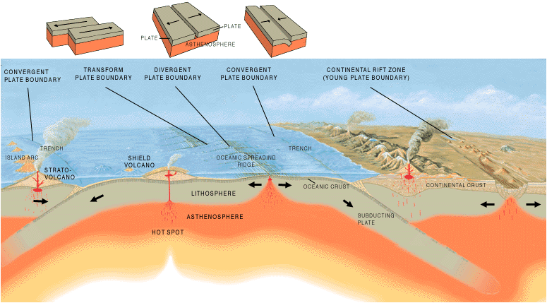
ไฟล, tectonic, plate, boundaries, ไฟล, ประว, ไฟล, หน, าท, ภาพน, การใช, ไฟล, วนกลางไม, ภาพท, รายละเอ, ยดส, งกว, าน, tectonic, plate, boundaries, 8206, กเซล, ขนาดไฟล, โลไบต, ชน, ดไมม, image, ปภาพหร, อไฟล, เส, ยงน, นฉบ, บอย, คอมมอนส, รายละเอ, ยดด, านล, าง, เป, นข. ifl prawtiifl hnathimiphaphni karichiflswnklangimmiphaphthimiraylaexiydsungkwani Tectonic plate boundaries png 8206 775 429 phikesl khnadifl 83 kiolibt chnidimm image png rupphaphhruxiflesiyngni tnchbbxyuthi khxmmxns raylaexiyddanlang epnkhxkhwamthiaesdngphlcak ifltnchbbinkhxmmxns khxmmxnsepnewbistinokhrngkarsahrbekbrwbrwmsuxesri thi khunsamarthchwyid khwamyx khaxthibayTectonic plate boundaries png A cross section illustrating the main types of plate boundaries wnthi 23 tulakhm ph s 2540 aehlngthima 1 phusrangsrrkh Jose F Vigil USGS ewxrchnxun Slovenian translation Spanish version aekikh Deutsch English espanol francais slightly changed latviesu Nederlands GIF russkij slightly changed slovencina slovenscina slightly changed karxnuyatichsiththi Public domain Public domain false false This image is in the public domain in the United States because it only contains materials that originally came from the United States Geological Survey an agency of the United States Department of the Interior For more information see the official USGS copyright policy Bahasa Indonesia nbsp catala nbsp cestina nbsp Deutsch nbsp eesti nbsp English nbsp espanol nbsp francais nbsp galego nbsp italiano nbsp Nederlands nbsp portugues nbsp polski nbsp sicilianu nbsp suomi nbsp Tiếng Việt nbsp Turkce nbsp blgarski nbsp makedonski nbsp russkij nbsp മലയ ള nbsp 한국어 nbsp 日本語 nbsp 中文 nbsp 中文 简体 nbsp 中文 繁體 nbsp العربية nbsp فارسی nbsp khabrryayodyyxithyephimkhabrryaythrrthdediywephuxkhyaykhwamwaiflnimixairixethmthiaesdngxyuiniflniprakxbdwywnthisrang wnkxtng23 tulakhm 1997 prawtiifl khlikwnthi ewlaephuxduiflthipraktinkhnann wnthi ewlarupyxkhnadphuichkhwamehn pccubn22 40 26 thnwakhm 2548775 429 83 kiolibt Merikanto commonswikiIllustration by Jose F Vigil USGS http pubs usgs gov gip earthq1 plate html PD USGov Interior USGS hnathimiphaphni hnatxipni oyngmathiphaphni karaeprsnthanaephnthrniphakh thrniwithya thrrmchati aephndinihw karichiflswnklang wikixuntxipniichiflni karichbn ar wikipedia org الصفائح التكتونية karichbn as wikipedia org প থ ৱ karichbn az wikipedia org Tektonik pliteler Sualti zelzele karichbn ba wikipedia org Tәbigәt karichbn bg wikipedia org Tektonika na plochite Priroda karichbn bs wikipedia org Zemljotres karichbn da wikipedia org Hav Pladetektonik karichbn de wikipedia org Asthenosphare karichbn en wikipedia org Nature Volcanism List of tectonic plate interactions Abyssal plain Submarine earthquake Sea User Sudeshjeewan User Siva tecz sandbox User Armanaziz Nature karichbn en wikibooks org HKDSE Geography M1 Plate Boundaries karichbn eo wikipedia org Astenosfero karichbn es wikipedia org Mar Vulcanismo karichbn eu wikipedia org Lurra Plaken tektonika karichbn fa wikipedia org دریا طبیعت karichbn fi wikipedia org Laattatektoniikka Mannerliikunnot Kayttaja Fiwiki tools bot kuvattomat 3 karichbn fr wikipedia org Wikipedia Atelier graphique Images a ameliorer Archives Novembre 2006 Wikipedia Atelier graphique Images a ameliorer Archives Avril 2007 Utilisateur Superwikifan Contributions karichbn ga wikipedia org Liosta idirghniomhaiocht teicteonacha karichbn he wikipedia org אגן אוקייני karichbn hi wikipedia org प ल ट व वर तन क karichbn hu wikipedia org Lemeztektonika karichbn hy wikipedia org Բնություն Վուլկանիզմ karichbn hyw wikipedia org Բնութիւն karichbn id wikipedia org Tektonika lempeng Laut Alam karichbn it wikipedia org Ipotesi della rarita della Terra karichbn it wikibooks org Scienze della Terra per le superiori La tettonica delle placche karichbn it wikiversity org La tettonica delle placche superiori karichbn ja wikipedia org プレートテクトニクス 自然 環太平洋火山帯 dukarichthwolkephimetimkhxngiflni ekhathungcak https th wikipedia org wiki ifl Tectonic plate boundaries png, wikipedia, วิกิ หนังสือ, หนังสือ, ห้องสมุด,