คำอธิบายUnited States land claims and cessions 1782-1802.png
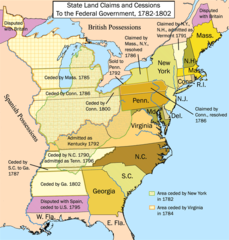
English: This is a map showing state land claims and cessions from 1782-1802 that I made. The disputed territory between New Hampshire and New York formed, in 1777, the independent country of 'New Connecticut' (later renamed 'Vermont') which eventually gained admission as the 14th state in 1791. Boundary disputes between states that were resolved before U.S. independence are not shown.
วันที่
2324 หรือ 2325 - 2344 หรือ 2345
date QS:P,+1500-00-00T00:00:00Z/6,P1319,+1782-00-00T00:00:00Z/9,P1326,+1802-00-00T00:00:00Z/9
ภาพแผนที่ทางประวัติศาสตร์นี้ ควรจะถูกสร้างใหม่เป็นกราฟิกส์เวกเตอร์ ซึ่งมีข้อดีอีกหลายประการ ดูเพิ่มเติมที่คอมมอนส์:สื่อต้องการเก็บกวาดสำหรับสารสนเทศเพิ่มเติม หากภาพนี้มีในรูปแบบกราฟิกส์เวกเตอร์อยู่แล้ว กรุณาอัปโหลดและแทนที่แม่แบบนี้ด้วย {{vector version available|ชื่อภาพใหม่}} แนะนำเป็นอย่างยิ่งให้ตั้งชื่อไฟล์เวกเตอร์ใหม่นั้นในรูปแบบ "United States land claims and cessions 1782-1802.svg" แล้วใส่แม่แบบ Vector version available (หรือ Vva) ซึ่งไม่ต้องใช้พารามิเตอร์ ชื่อภาพใหม่
This is a map showing state land claims and cessions from 1782-1802 that I made. Boundary disputes between states that were resolved before independence are not shown.
หน้าที่มีภาพนี้
ไม่มีหน้าใดโยงมาที่ภาพนี้
การใช้ไฟล์ส่วนกลาง
วิกิอื่นต่อไปนี้ใช้ไฟล์นี้:
Midwestern United States
Treaty of Paris (1783)
Northwest Territory
U.S. territorial sovereignty
Ohio Country
Historical regions of the United States
State cessions
User:Kmusser/Images
History of Michigan
Portal:Michigan
User:Notuncurious/Working/tmp3
Confederation period
User:Notuncurious/Working/tmp6
Talk:List of capitals in the United States/Archive 1
ไฟล, united, states, land, claims, cessions, 1782, 1802, ไฟล, ประว, ไฟล, หน, าท, ภาพน, การใช, ไฟล, วนกลางขนาดของต, วอย, างน, กเซล, ความละเอ, ยดอ, กเซล, กเซล, กเซล, ภาพท, ความละเอ, ยดส, งกว, 8206, กเซล, ขนาดไฟล, โลไบต, ชน, ดไมม, image, ปภาพหร, อไฟล, เส, ยงน, นฉ. ifl prawtiifl hnathimiphaphni karichiflswnklangkhnadkhxngtwxyangni 573 600 phikesl khwamlaexiydxun 229 240 phikesl 458 480 phikesl 747 782 phikesl duphaphthimikhwamlaexiydsungkwa 8206 747 782 phikesl khnadifl 145 kiolibt chnidimm image png rupphaphhruxiflesiyngni tnchbbxyuthi khxmmxns raylaexiyddanlang epnkhxkhwamthiaesdngphlcak ifltnchbbinkhxmmxns khxmmxnsepnewbistinokhrngkarsahrbekbrwbrwmsuxesri thi khunsamarthchwyid khwamyx khaxthibayUnited States land claims and cessions 1782 1802 png English This is a map showing state land claims and cessions from 1782 1802 that I made The disputed territory between New Hampshire and New York formed in 1777 the independent country of New Connecticut later renamed Vermont which eventually gained admission as the 14th state in 1791 Boundary disputes between states that were resolved before U S independence are not shown wnthi 2324 hrux 2325 2344 hrux 2345 date QS P 1500 00 00T00 00 00Z 6 P1319 1782 00 00T00 00 00Z 9 P1326 1802 00 00T00 00 00Z 9 aehlngthima ngankhxngtw phusrangsrrkh Kmusser ewxrchnxun eyxrmn karxnuyatichsiththi khapheca inthanaphuthuxlikhsiththikhxngphaphhruxsuxni xnuyatihichphaphhruxsuxniphayitenguxnikhtxipniiflnixyuphayitsyyaxnuyat khriexthifkhxmmxns aebbaesdngthima xnuyataebbediywkn 2 5 thwipkhunsamarth thicaaebngpn thicathasaena aeckcay aelasngngandngklawtxip thicaeriyberiyngihm thicaddaeplngngandngklaw phayitenguxnikhtxipni aesdngthima khuntxngihekiyrtiecakhxngnganxyangehmaasm odyephimlingkipyngsyyaxnuyat aelarabuhakmikarepliynaeplng khunxacthaechnniidinrupaebbidkidtamkhwr aettxngimichinlksnathiaenawaphuihxnuyatsnbsnunkhunhruxkarichngankhxngkhun xnuyataebbediywkn hakkhunddaeplng epliynrup hruxtxetimnganni khuntxngichsyyaxnuyataebbediywknhruxaebbthiehmuxnkbsyyaxnuyatthiichkbnganniethannhttps creativecommons org licenses by sa 2 5 CC BY SA 2 5 Creative Commons Attribution Share Alike 2 5 true true phaphaephnthithangprawtisastrni khwrcathuksrangihmepnkrafiksewketxr sungmikhxdixikhlayprakar duephimetimthikhxmmxns suxtxngkarekbkwadsahrbsarsnethsephimetim hakphaphnimiinrupaebbkrafiksewketxrxyuaelw krunaxpohldaelaaethnthiaemaebbnidwy vector version available i chuxphaphihm i aenanaepnxyangyingihtngchuxiflewketxrihmnninrupaebb United States land claims and cessions 1782 1802 svg aelwisaemaebb Vector version available hrux Vva sungimtxngichpharamietxr chuxphaphihmkhabrryayodyyxithyephimkhabrryaythrrthdediywephuxkhyaykhwamwaiflnimixairixethmthiaesdngxyuiniflniprakxbdwyphusrangbangkhathiimmiixethmwikisnethschuxphusrangsrrkh Kmusserchuxphuichwikimiediy Kmusseryuxaraexl http commons wikimedia org wiki User KmussersthanalikhsiththimilikhsiththisyyaxnuyatCreative Commons Attribution ShareAlike 2 5 Generic nbsp xngkvsthimakhxngiflkarsrangdngedimodyphuxpohldMIME type nbsp xngkvsimage png prawtiifl khlikwnthi ewlaephuxduiflthipraktinkhnann wnthi ewlarupyxkhnadphuichkhwamehn pccubn00 12 17 mkrakhm 2555747 782 145 kiolibt Ras67cropped 21 26 28 knyayn 2549765 800 154 kiolibt Kmusser 21 12 25 knyayn 2549765 800 154 kiolibt Kmusser 00 15 22 knyayn 2549765 800 155 kiolibt Kmusser 04 46 21 knyayn 2549765 800 155 kiolibt Kmusser 04 42 21 knyayn 2549765 800 495 kiolibt KmusserThis is a map showing state land claims and cessions from 1782 1802 that I made Boundary disputes between states that were resolved before independence are not shown hnathimiphaphni immihnaidoyngmathiphaphnikarichiflswnklang wikixuntxipniichiflni karichbn ar wikipedia org مستخدم أيوب مقالات 2 karichbn bh wikipedia org त रह उपन व श karichbn ca wikipedia org Teatre oest de la Guerra de la Revolucio Americana karichbn de wikipedia org Wikipedia Kartenwerkstatt Archiv 2018 05 karichbn en wikipedia org History of the United States Midwestern United States Treaty of Paris 1783 Northwest Territory U S territorial sovereignty Ohio Country Historical regions of the United States State cessions User Kmusser Images History of Michigan Portal Michigan User Notuncurious Working tmp3 Confederation period User Notuncurious Working tmp6 Talk List of capitals in the United States Archive 1 User Drdpw sandbox2 User AkeAcres87 sandbox karichbn es wikipedia org Trece Colonias Anexo Regiones historicas de Estados Unidos Ambito territorial de Estados Unidos karichbn fa wikipedia org مستعمرات سیزده گانه karichbn fr wikipedia org Traite de Paris 1783 Territoire du Nord Ouest Etats Unis Regions historiques des Etats Unis Histoire de l Ohio karichbn he wikipedia org חוזה פריז 1783 גבול ארצות הברית קנדה karichbn hi wikipedia org त रह उपन व श स य क त र ज य अम र क क इत ह स karichbn it wikipedia org Regioni storiche degli Stati Uniti d America Presidenza di George Washington Presidenza di Thomas Jefferson karichbn ja wikipedia org 北西部領土 アメリカ合衆国 南西部領土 アメリカ合衆国 karichbn ko wikipedia org 북서부 영토 karichbn ms wikipedia org Kawasan bersejarah di Amerika Syarikat karichbn nl wikipedia org Noordwestterritorium karichbn no wikipedia org De tretten kolonier karichbn pt wikipedia org Regioes historicas dos Estados Unidos Evolucao territorial dos Estados Unidos karichbn ru wikipedia org Staryj Severo Zapad karichbn sq wikipedia org Traktati i Parisit 1783 karichbn ta wikipedia org பத ன ம ன ற க ட ய ற றங கள karichbn tr wikipedia org On Uc Koloni karichbn tum wikipedia org History of the United States karichbn vi wikipedia org Lanh thổ Hoa Kỳ dukarichthwolkephimetimkhxngiflni ekhathungcak https th wikipedia org wiki ifl United States land claims and cessions 1782 1802 png, wikipedia, วิกิ หนังสือ, หนังสือ, ห้องสมุด,