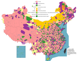
English: Note: this map contains various disputed country claims, includes but not limited to Sansha, South Tibet region (part of Arunachal Pradesh), Kinmen and the Matsu Islands.
This image is expected to always be the most recent one. Feel free to update it when needed.
This file may be updated to reflect new information. If you wish to use a specific version of the file without new updates being mirrored, please upload the required version as a separate file.
ความย่อ
คำอธิบายChina county-level divisions and administrative divisions (PRoC claim).png
English: Map of China, shows counties, county-level cities, county-level districts, autonomous counties and banners, banners, etc.
ภาพแผนที่นี้ ควรจะถูกสร้างใหม่เป็นกราฟิกส์เวกเตอร์ ซึ่งมีข้อดีอีกหลายประการ ดูเพิ่มเติมที่คอมมอนส์:สื่อต้องการเก็บกวาดสำหรับสารสนเทศเพิ่มเติม หากภาพนี้มีในรูปแบบกราฟิกส์เวกเตอร์อยู่แล้ว กรุณาอัปโหลดและแทนที่แม่แบบนี้ด้วย {{vector version available|ชื่อภาพใหม่}} แนะนำเป็นอย่างยิ่งให้ตั้งชื่อไฟล์เวกเตอร์ใหม่นั้นในรูปแบบ "China county-level divisions and administrative divisions (PRoC claim).svg" แล้วใส่แม่แบบ Vector version available (หรือ Vva) ซึ่งไม่ต้องใช้พารามิเตอร์ ชื่อภาพใหม่
Annotations
InfoField
This image is annotated: View the annotations at Commons
1703
3275
979
337
6246
4937
India's controlled from the part of the internal Arunachal Pradesh, but it claims with two-prefecture level cities in the country.
370
1868
362
362
6246
4937
Aksai Chin is disputed, but China controls in this prefecture and claimed by India.
5481
3744
189
148
6246
4937
China's claims the disputed Diaoyu Islands (Senkaku Islands), and its part of a claimed territory, and controlled by Japan.
4929
4040
74
74
6246
4937
Kinmen annexation of Fujian province, and it is controlled by Republic of China.
1325
3678
774
1037
6246
4937
China claims most of the South China Sea, which is disputed between Brunei, the People's Republic of China, the Republic of China/Taiwan, Indonesia, Malaysia, the Philippines, and Vietnam.
ไฟล, china, county, level, divisions, administrative, divisions, proc, claim, ไฟล, ประว, ไฟล, หน, าท, ภาพน, การใช, ไฟล, วนกลาง, อม, ลเก, ยวก, บภาพขนาดของต, วอย, างน, กเซล, ความละเอ, ยดอ, กเซล, กเซล, กเซล, กเซล, กเซล, กเซล, ภาพท, ความละเอ, ยดส, งกว, 8206, กเซล,. ifl prawtiifl hnathimiphaphni karichiflswnklang khxmulekiywkbphaphkhnadkhxngtwxyangni 759 600 phikesl khwamlaexiydxun 304 240 phikesl 607 480 phikesl 972 768 phikesl 1 280 1 012 phikesl 2 560 2 023 phikesl 6 246 4 937 phikesl duphaphthimikhwamlaexiydsungkwa 8206 6 246 4 937 phikesl khnadifl 1 54 emkaibt chnidimm image png rupphaphhruxiflesiyngni tnchbbxyuthi khxmmxns raylaexiyddanlang epnkhxkhwamthiaesdngphlcak ifltnchbbinkhxmmxns khxmmxnsepnewbistinokhrngkarsahrbekbrwbrwmsuxesri thi khunsamarthchwyid English Note this map contains various disputed country claims includes but not limited to Sansha South Tibet region part of Arunachal Pradesh Kinmen and the Matsu Islands 日本語 ノート この地図には さまざまな係争中の国の主張が含まれています さまざまな分野で主に統制と主張が争われている アルナーチャルプラデーシュ州やトランスカラコラムトラクトの一部などですが デフォルトで主張または管理されています 台湾を含む この地図には 福建省の近くの金門と馬祖島の一部が含まれていますが デフォルトでは暗い色に使用されます 三社県地級市が争われている マップは ベトナムと台湾からの主張のために西沙諸島に異議を唱えたものが示されていますが デフォルトで示されています 中文 注 该地图包含多个主权争议地区 包括但不限于三沙市 藏南地区 印度称阿鲁纳恰尔邦 金门和马祖群岛等 This image is expected to always be the most recent one Feel free to update it when needed This file may be updated to reflect new information If you wish to use a specific version of the file without new updates being mirrored please upload the required version as a separate file khwamyx khaxthibayChina county level divisions and administrative divisions PRoC claim png English Map of China shows counties county level cities county level districts autonomous counties and banners banners etc 日本語 中国の地図は 郡 郡レベルの都市 郡レベルの地区 自治県とバナー バナーなどを示しています Russkij Karta Kitaya pokazyvaet uezdy goroda uezdnogo urovnya uezdnye rajony avtonomnye uezdy i bannery bannery i t D 中文 简体 中国地图 显示县 县级市 县级区 自治县和旗 自治旗等 中文 繁體 中國地圖 顯示縣 縣級市 縣級區 自治縣和旗 自治旗等 wnthi File uploaded November 25 2021 Original uploaded December 9 2009 aehlngthima Legend English nbsp County nbsp County level city nbsp County level district nbsp Autonomous county nbsp Banner nbsp Autonomous banner nbsp No county level division Sub prefectural level division nbsp Special district nbsp Special administrative region 中文 简体 nbsp 县 nbsp 县级市 nbsp 县级区 nbsp 自治县 nbsp 旗 nbsp 自治旗 nbsp 无县级 副地级 nbsp 特区 nbsp 特别行政区 phusrangsrrkh AichiWikiFixer and Not logging in Original ASDFGH karxnuyat karichiflniihm Map of China administrative divisions khapheca inthanaphuthuxlikhsiththikhxngphaphhruxsuxni xnuyatihichphaphhruxsuxniphayitenguxnikhtxipni Public domain Public domain false false phaphni khadkhunsmbtisahrbkarmilikhsiththi dngnnphaphnicungepn satharnsmbti enuxngcakepnsmbtiswnrwmaelaimmikarrabukhwamepnecakhxng prakasnimiphlthwolk karxnuyatichsiththi khapheca inthanaphuthuxlikhsiththikhxngphaphhruxsuxni xnuyatihichphaphhruxsuxniphayitenguxnikhtxipniiflnixyuphayitsyyaxnuyat khriexthifkhxmmxns aebbaesdngthima xnuyataebbediywkn 4 0 nanachatikhunsamarth thicaaebngpn thicathasaena aeckcay aelasngngandngklawtxip thicaeriyberiyngihm thicaddaeplngngandngklaw phayitenguxnikhtxipni aesdngthima khuntxngihekiyrtiecakhxngnganxyangehmaasm odyephimlingkipyngsyyaxnuyat aelarabuhakmikarepliynaeplng khunxacthaechnniidinrupaebbidkidtamkhwr aettxngimichinlksnathiaenawaphuihxnuyatsnbsnunkhunhruxkarichngankhxngkhun xnuyataebbediywkn hakkhunddaeplng epliynrup hruxtxetimnganni khuntxngichsyyaxnuyataebbediywknhruxaebbthiehmuxnkbsyyaxnuyatthiichkbnganniethannhttps creativecommons org licenses by sa 4 0 CC BY SA 4 0 Creative Commons Attribution Share Alike 4 0 true true phaphaephnthini khwrcathuksrangihmepnkrafiksewketxr sungmikhxdixikhlayprakar duephimetimthikhxmmxns suxtxngkarekbkwadsahrbsarsnethsephimetim hakphaphnimiinrupaebbkrafiksewketxrxyuaelw krunaxpohldaelaaethnthiaemaebbnidwy vector version available i chuxphaphihm i aenanaepnxyangyingihtngchuxiflewketxrihmnninrupaebb China county level divisions and administrative divisions PRoC claim svg aelwisaemaebb Vector version available hrux Vva sungimtxngichpharamietxr chuxphaphihm AnnotationsInfoFieldThis image is annotated View the annotations at Commons1703 3275 979 337 6246 4937 India s controlled from the part of the internal Arunachal Pradesh but it claims with two prefecture level cities in the country 370 1868 362 362 6246 4937 Aksai Chin is disputed but China controls in this prefecture and claimed by India 5481 3744 189 148 6246 4937 China s claims the disputed Diaoyu Islands Senkaku Islands and its part of a claimed territory and controlled by Japan 4929 4040 74 74 6246 4937 Kinmen annexation of Fujian province and it is controlled by Republic of China 1325 3678 774 1037 6246 4937 China claims most of the South China Sea which is disputed between Brunei the People s Republic of China the Republic of China Taiwan Indonesia Malaysia the Philippines and Vietnam khabrryayodyyxithyephimkhabrryaythrrthdediywephuxkhyaykhwamwaiflnimixairxngkvsMap of China shows that divided into counties county level cities districts etc yipun中国の地図は 郡 県級市 地区などに分割されていることを示しています rsesiyKarta Kitaya pokazyvaet chto ona razdelena na uezdy uezdnye goroda rajony i t d cintwyx中国地图 显示分为县 县级市 区等 sepnMapa de China muestra que se divide en condados ciudades a nivel de condado distritos etc mxngokeliyHyatad ulsyn gazryn zurag n muzh hoshuuny tovshnij hot dүүreg geh met huvaagdsan ixethmthiaesdngxyuiniflniprakxbdwyphusrangbangkhathiimmiixethmwikisnethsyuxaraexl https commons wikimedia org wiki user ASDFGHJchuxphuichwikimiediy ASDFGHJchuxphusrangsrrkh ASDFGHJsthanalikhsiththimilikhsiththisatharnsmbtisyyaxnuyatCreative Commons Attribution ShareAlike 3 0 Unported nbsp xngkvsCreative Commons Attribution ShareAlike 4 0 International nbsp xngkvswnthisrang wnkxtng9 thnwakhm 2009thimakhxngiflkarsrangdngedimodyphuxpohldMIME type nbsp xngkvsimage pngchecksum nbsp xngkvs943ab4791b5ca8b2d5709fb888cba2eaeb2f874fwithikarkahnd SHA 1 nbsp xngkvsdata size nbsp xngkvs1 619 764 ibtkhwamsung4 937 phikeslkhwamkwang6 246 phikesl prawtiifl khlikwnthi ewlaephuxduiflthipraktinkhnann lasud ekasud du ihmkwa 10 ekakwa 10 10 20 50 100 250 500 wnthi ewlarupyxkhnadphuichkhwamehn pccubn15 59 1 singhakhm 25666 246 4 937 1 54 emkaibt MaanshenAdd Baiyang update and fix Nanchang borders 15 32 1 singhakhm 25666 246 4 937 1 54 emkaibt MaanshenUpdate Tsona County gt Tsona City Mainling County gt Mainling City 19 30 31 krkdakhm 25666 246 4 937 1 41 emkaibt Baomi 23 35 16 krkdakhm 25666 246 4 937 1 59 emkaibt Joefrance1995That old nine dashed line is badly drawn 16 52 17 kumphaphnth 25666 246 4 937 1 55 emkaibt 孟天皓修改香港区界 06 06 3 singhakhm 25656 246 4 937 1 55 emkaibt MaanshenUpdate disputed claimed borders white with stroke is not claimed and filled in color is claimed 07 08 20 emsayn 25656 246 4 937 1 54 emkaibt MaanshenFix borders between Ili 039 s Kuytun Huyanghe and Karamay 06 41 20 emsayn 25656 246 4 937 1 54 emkaibt MaanshenFix colors again in Honghe counties 08 45 31 minakhm 25656 246 4 937 1 54 emkaibt MaanshenFix some colors 07 59 29 minakhm 25656 246 4 937 1 54 emkaibt MaanshenFix colors in Shanxi with Fenyang and Xiaoyi lasud ekasud du ihmkwa 10 ekakwa 10 10 20 50 100 250 500 hnathimiphaphni hnatxipni oyngmathiphaphni xaephxkhxngpraethscin ekhtkarpkkhrxngkhxngpraethscin karichiflswnklang wikixuntxipniichiflni karichbn ar wikipedia org لواء منغوليا الداخلية karichbn ast wikipedia org Condau de la Republica Popular China Comarca karichbn az wikipedia org Xosun CXR karichbn ca wikipedia org Xian karichbn ce wikipedia org CHR uezdash karichbn cs wikipedia org Administrativni deleni Ciny Mestske okresy v Cine Mestske obvody v Cine Okresy v Cine Autonomni okresy v Cine karichbn en wikipedia org Administrative divisions of China User Chochopk Administrative divisions of the People s Republic of China User SilverStar54 County level divisions of China User SilverStar54 Administrative divisions of China County level divisions of China karichbn es wikipedia org Bandera Mongolia Interior Condado de la Republica Popular China Comarca karichbn fa wikipedia org شهرستان های جمهوری خلق چین karichbn fi wikipedia org Kiinan alueellinen hallinto karichbn fr wikipedia org Xian subdivision administrative Banniere autonome karichbn id wikipedia org County di Tiongkok karichbn ja wikipedia org 民族区域自治 市轄区 自治県 県 中華人民共和国 karichbn mk wikipedia org Okolii vo Kina karichbn nl wikipedia org Arrondissement China karichbn no wikipedia org Fylke Kina karichbn pnb wikipedia org عوامی جمہوریہ چین دیاں خود مختار کاؤنٹیاں karichbn ru wikipedia org Administrativnoe delenie Kitajskoj Narodnoj Respubliki Gorod uezdnogo znacheniya Uezdy KNR Hoshun KNR karichbn sv wikipedia org Kinas harad Inre Mongoliets baner karichbn tr wikipedia org Cin in ilceleri karichbn uk wikipedia org Administrativnij podil KNR Povit KNR karichbn ur wikipedia org عوامی جمہوریہ چین کی کاؤنٹیاں karichbn vi wikipedia org Huyện Trung Quốc karichbn www wikidata org Q1289426 karichbn zh wikipedia org 中华人民共和国行政区划 自治旗 县级行政区 旗 行政区划 User Patlabor Ingram 工作区01 User Tp61i6m42008 中國行政區劃總整理khxmulekiywkbphaph phaphnimikhxmulephimetim sungswnihymacakklxngdicitxlhruxsaeknenxrthisamarthekbkhxmuldngklawiwrwmkbphaphid thaphaphnithukprbprungaekikhhruxepliynaeplngcakedim khxmulbangxyangcayngkhngimepliynaeplngehmuxnphaphthithukprbprungaekikhnnsxftaewrthiichAdobe Photoshop CC Windows ewlathiaeplngepndicithl04 23 1 singhakhm 2566aekikhphaphlasud04 25 1 singhakhm 2566wnthiaekikhkhxmulemtalasud04 25 1 singhakhm 2566ID echphaakhxngexksartnchbbxmp did 4552ce6b fd2b 3442 9e40 a2eba70b0033khwamlaexiydaenwnxn37 8 dpckhwamlaexiydaenwtng37 8 dpc ekhathungcak https th wikipedia org wiki ifl China county level divisions and administrative divisions PRoC claim png, wikipedia, วิกิ หนังสือ, หนังสือ, ห้องสมุด,