This map has been uploaded by Electionworld from en.wikipedia.org to enable the Wikimedia Atlas of the World . Original uploader to en.wikipedia.org was Adam Carr, known as Adam Carr at en.wikipedia.org. Electionworld is not the creator of this map. Licensing information is below.
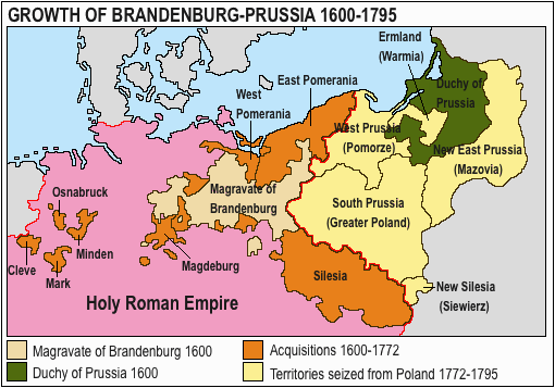
Growth of Prussia en:Image:Ac.prussiamap2.gif
ภาพแผนที่ทางประวัติศาสตร์นี้ ควรจะถูกสร้างใหม่เป็นกราฟิกส์เวกเตอร์ ซึ่งมีข้อดีอีกหลายประการ ดูเพิ่มเติมที่คอมมอนส์:สื่อต้องการเก็บกวาดสำหรับสารสนเทศเพิ่มเติม หากภาพนี้มีในรูปแบบกราฟิกส์เวกเตอร์อยู่แล้ว กรุณาอัปโหลดและแทนที่แม่แบบนี้ด้วย {{vector version available|ชื่อภาพใหม่}} แนะนำเป็นอย่างยิ่งให้ตั้งชื่อไฟล์เวกเตอร์ใหม่นั้นในรูปแบบ "Acprussiamap2.svg" แล้วใส่แม่แบบ Vector version available (หรือ Vva) ซึ่งไม่ต้องใช้พารามิเตอร์ ชื่อภาพใหม่
ไฟล, acprussiamap2, ไฟล, ประว, ไฟล, หน, าท, ภาพน, การใช, ไฟล, ามโครงการไม, ภาพท, รายละเอ, ยดส, งกว, าน, acprussiamap2, 8206, กเซล, ขนาดไฟล, โลไบต, ชน, ดไมม, image, นาท, ปภาพหร, อไฟล, เส, ยงน, นฉบ, บอย, คอมมอนส, รายละเอ, ยดด, านล, าง, เป, นข, อความท, แสดงผลจาก,. ifl prawtiifl hnathimiphaphni karichiflkhamokhrngkarimmiphaphthimiraylaexiydsungkwani Acprussiamap2 gif 8206 510 357 phikesl khnadifl 27 kiolibt chnidimm image gif 0 1 winathi rupphaphhruxiflesiyngni tnchbbxyuthi khxmmxns raylaexiyddanlang epnkhxkhwamthiaesdngphlcak ifltnchbbinkhxmmxns khxmmxnsepnewbistinokhrngkarsahrbekbrwbrwmsuxesri thi khunsamarthchwyid The factual accuracy of this map or the file name is disputed Reason Please see the relevant discussion on the talk page This image was copied from wikipedia pt The original description was Licenca GNU fonte en Wikipedia xnuyatihkhdlxk aeckcayaela hruxddaeprexksarniphayitenguxnikhkhxngsyyaxnuyatexksaresrikhxngknu run 1 2 hruxrunid nbcaknithixxkodymulnithisxftaewresri odyimmiswnidhamaekikh immikhxkhwampkhnaaelapkhlng saenakhxngsyyaxnuyatrwmxyuinswnchux syyaxnuyatexksaresrikhxngknuhttp www gnu org copyleft fdl html GFDL GNU Free Documentation License true true iflnixyuphayitsyyaxnuyat khriexthifkhxmmxns aebbaesdngthima xnuyataebbediywkn 3 0 tnchbb khunsamarth thicaaebngpn thicathasaena aeckcay aelasngngandngklawtxip thicaeriyberiyngihm thicaddaeplngngandngklaw phayitenguxnikhtxipni aesdngthima khuntxngihekiyrtiecakhxngnganxyangehmaasm odyephimlingkipyngsyyaxnuyat aelarabuhakmikarepliynaeplng khunxacthaechnniidinrupaebbidkidtamkhwr aettxngimichinlksnathiaenawaphuihxnuyatsnbsnunkhunhruxkarichngankhxngkhun xnuyataebbediywkn hakkhunddaeplng epliynrup hruxtxetimnganni khuntxngichsyyaxnuyataebbediywknhruxaebbthiehmuxnkbsyyaxnuyatthiichkbnganniethann payaesdngsthanalikhsiththinithukephimephuxihepniptamkarepliynaeplngsyyaxnuyatkhxngmulnithiwikimiediy cak GFDL ipyng GFDL khwbkhukb CC BY SA 3 0 http creativecommons org licenses by sa 3 0 CC BY SA 3 0 Creative Commons Attribution Share Alike 3 0 true true This map has been uploaded by Electionworld from en wikipedia org to enable the Wikimedia Atlas of the World Original uploader to en wikipedia org was Adam Carr known as Adam Carr at en wikipedia org Electionworld is not the creator of this map Licensing information is below Growth of Prussia en Image Ac prussiamap2 gif phaphaephnthithangprawtisastrni khwrcathuksrangihmepnkrafiksewketxr sungmikhxdixikhlayprakar duephimetimthikhxmmxns suxtxngkarekbkwadsahrbsarsnethsephimetim hakphaphnimiinrupaebbkrafiksewketxrxyuaelw krunaxpohldaelaaethnthiaemaebbnidwy vector version available i chuxphaphihm i aenanaepnxyangyingihtngchuxiflewketxrihmnninrupaebb Acprussiamap2 svg aelwisaemaebb Vector version available hrux Vva sungimtxngichpharamietxr chuxphaphihmkhabrryayodyyxithyephimkhabrryaythrrthdediywephuxkhyaykhwamwaiflnimixairixethmthiaesdngxyuiniflniprakxbdwysthanalikhsiththimilikhsiththisyyaxnuyatGNU Free Documentation License version 1 2 or later nbsp xngkvsCreative Commons Attribution ShareAlike 3 0 Unported nbsp xngkvsMIME type nbsp xngkvsimage gifchecksum nbsp xngkvs16c30baaa380e440beb3e17fc730f9e96337f67dwithikarkahnd SHA 1 nbsp xngkvsdata size nbsp xngkvs28 096 ibtrayaewla0 1 winathikhwamsung357 phikeslkhwamkwang510 phikesl prawtiifl khlikwnthi ewlaephuxduiflthipraktinkhnann wnthi ewlarupyxkhnadphuichkhwamehn pccubn20 17 15 minakhm 2563510 357 27 kiolibt E 960Ermland correction 19 50 15 minakhm 2563510 357 27 kiolibt E 960Names of territories and format 02 44 2 mithunayn 2552510 357 14 kiolibt HohumChanged colours to more cartographic less garish Made sea blue instead of portions of land 01 36 26 singhakhm 2549510 357 15 kiolibt LeonardoGThis image was copied from wikipedia pt The original description was Licenca GNU fonte en Wikipedia GFDL en Image Ac prussiamap2 gif border 1 date time username resolution size edit summary hnathimiphaphni hnatxipni oyngmathiphaphni phraecafridrichthi 2 aehngprsesiy karichiflkhamokhrngkar wikixuntxipniichiflni karichbn af wikipedia org Brandenburg karichbn ar wikipedia org فريدرش العظيم الأراضي الشرقية السابقة لألمانيا تطور حدود الأراضي الألمانية karichbn ast wikipedia org Federicu II el Grande Margraviatu de Brandeburgu karichbn bg wikipedia org Istoriya na Germaniya karichbn ca wikipedia org Silesia Usuari Jolle traduccions Marcgraviat de Brandenburg karichbn cs wikipedia org Pruska armada Pruske kralovstvi Dejiny Pruska Vychodni uzemi Nemecke rise karichbn el wikipedia org Prwsikos Diamelismos karichbn en wikipedia org History of Germany House of Hohenzollern Prussia Margraviate of Brandenburg Prussian Army Territorial evolution of Germany Subdivisions of the Polish Lithuanian territories following the partitions Prussian Partition 18th century history of Germany Brandenburg Pomeranian conflict Treaty of Vossem 1673 User Falcaorib User JMvanDijk Sandbox 9 Box 15 Box 3 karichbn es wikipedia org Casa de Hohenzollern Federico II el Grande Margraviato de Brandeburgo Antiguos territorios orientales de Alemania karichbn et wikipedia org Preisi armee karichbn eu wikipedia org Germaniako Erromatar Inperio Santua Aro Modernoa Alemaniako historia karichbn fa wikipedia org فریدریش دوم پادشاه پروس کاربر Aliesy13 ارتش پروس karichbn fi wikipedia org Brandenburgin markkreivikunta karichbn fr wikipedia org Royaume de Prusse Nouvelle Prusse Orientale Prusse Meridionale Armee prussienne Anciens territoires de l Est de l Allemagne karichbn he wikipedia org היסטוריה של גרמניה במאה ה 18 karichbn hy wikipedia org Մասնակից Dovlat 20 Ավազարկղ Պրուսական Լեհաստան karichbn it wikipedia org Marca di Brandeburgo Slesia Prussia Meridionale Ostsiedlung dukarichkhamokhrngkarephimetimkhxngiflni ekhathungcak https th wikipedia org wiki ifl Acprussiamap2 gif, wikipedia, วิกิ หนังสือ, หนังสือ, ห้องสมุด,