This file is licensed under the Creative Commons Attribution-Share Alike 4.0 International, 3.0 Unported, 2.5 Generic, 2.0 Generic and 1.0 Generic license.
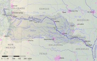
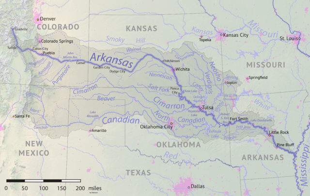
{{Information |description ={{en|1=Map of the Arkansas River drainage basin. Created using USGS National Map and NASA SRTM data.}} |date =2019-05-17 |source =Own work |author =Shannon1 }} Category:Arkansas River
ไฟล, arkansas, river, basin, ไฟล, ประว, ไฟล, หน, าท, ภาพน, การใช, ไฟล, วนกลาง, อม, ลเก, ยวก, บภาพขนาดของต, วอย, างน, กเซล, ความละเอ, ยดอ, กเซล, กเซล, กเซล, ภาพท, ความละเอ, ยดส, งกว, 8206, กเซล, ขนาดไฟล, เมกะไบต, ชน, ดไมม, image, ปภาพหร, อไฟล, เส, ยงน, นฉบ, บอย. ifl prawtiifl hnathimiphaphni karichiflswnklang khxmulekiywkbphaphkhnadkhxngtwxyangni 800 506 phikesl khwamlaexiydxun 320 202 phikesl 640 405 phikesl 1 200 759 phikesl duphaphthimikhwamlaexiydsungkwa 8206 1 200 759 phikesl khnadifl 1 46 emkaibt chnidimm image png rupphaphhruxiflesiyngni tnchbbxyuthi khxmmxns raylaexiyddanlang epnkhxkhwamthiaesdngphlcak ifltnchbbinkhxmmxns khxmmxnsepnewbistinokhrngkarsahrbekbrwbrwmsuxesri thi khunsamarthchwyid khwamyx khaxthibayArkansas river basin map png English Map of the Arkansas River drainage basin Created using USGS National Map and NASA SRTM data wnthi 17 phvsphakhm ph s 2562 aehlngthima ngankhxngtw phusrangsrrkh Shannon1 karxnuyatichsiththi khapheca inthanaphuthuxlikhsiththikhxngphaphhruxsuxni xnuyatihichphaphhruxsuxniphayitenguxnikhtxipni xnuyatihkhdlxk aeckcayaela hruxddaeprexksarniphayitenguxnikhkhxngsyyaxnuyatexksaresrikhxngknu run 1 2 hruxrunid nbcaknithixxkodymulnithisxftaewresri odyimmiswnidhamaekikh immikhxkhwampkhnaaelapkhlng saenakhxngsyyaxnuyatrwmxyuinswnchux syyaxnuyatexksaresrikhxngknuhttp www gnu org copyleft fdl html GFDL GNU Free Documentation License true trueThis file is licensed under the Creative Commons Attribution Share Alike 4 0 International 3 0 Unported 2 5 Generic 2 0 Generic and 1 0 Generic license khunsamarth thicaaebngpn thicathasaena aeckcay aelasngngandngklawtxip thicaeriyberiyngihm thicaddaeplngngandngklaw phayitenguxnikhtxipni aesdngthima khuntxngihekiyrtiecakhxngnganxyangehmaasm odyephimlingkipyngsyyaxnuyat aelarabuhakmikarepliynaeplng khunxacthaechnniidinrupaebbidkidtamkhwr aettxngimichinlksnathiaenawaphuihxnuyatsnbsnunkhunhruxkarichngankhxngkhun xnuyataebbediywkn hakkhunddaeplng epliynrup hruxtxetimnganni khuntxngichsyyaxnuyataebbediywknhruxaebbthiehmuxnkbsyyaxnuyatthiichkbnganniethannhttps creativecommons org licenses by sa 4 0 CC BY SA 4 0 Creative Commons Attribution Share Alike 4 0 true truekhunsamartheluxksyyaxnuyatdngklawtamtxngkarkhabrryayodyyxithyephimkhabrryaythrrthdediywephuxkhyaykhwamwaiflnimixairixethmthiaesdngxyuiniflniprakxbdwyphusrangbangkhathiimmiixethmwikisnethshnathikhxngwtthuphayitpraphcnni changphaphchuxphuichwikimiediy Shannon1yuxaraexl https commons wikimedia org wiki user Shannon1chuxphusrangsrrkh Shannon1sthanalikhsiththimilikhsiththisyyaxnuyatCreative Commons Attribution ShareAlike 2 5 Generic nbsp xngkvsCreative Commons Attribution ShareAlike 4 0 International nbsp xngkvsCreative Commons Attribution ShareAlike 2 0 Generic nbsp xngkvsGNU Free Documentation License version 1 2 or later nbsp xngkvsCreative Commons Attribution ShareAlike 1 0 Generic nbsp xngkvsCreative Commons Attribution ShareAlike 3 0 Unported nbsp xngkvsthimakhxngiflkarsrangdngedimodyphuxpohldwnthisrang wnkxtng17 phvsphakhm 2019 prawtiifl khlikwnthi ewlaephuxduiflthipraktinkhnann wnthi ewlarupyxkhnadphuichkhwamehn pccubn00 41 19 phvsphakhm 25621 200 759 1 46 emkaibt Shannon1 Information description en 1 Map of the Arkansas River drainage basin Created using USGS National Map and NASA SRTM data date 2019 05 17 source Own work author Shannon1 Category Arkansas River hnathimiphaphni hnatxipni oyngmathiphaphni aemnaxarkhnsx karichiflswnklang wikixuntxipniichiflni karichbn af wikipedia org Arkansasrivier karichbn azb wikipedia org آرکانزاس چایی karichbn bg wikipedia org Arkanzas reka karichbn ceb wikipedia org Arkansas River karichbn chy wikipedia org Mo sooneo he e karichbn cs wikipedia org Arkansas reka karichbn de wikipedia org Arkansas River Benutzer Bulwersator Echo Maps Rivers karichbn el wikipedia org Arkanso potamos karichbn en wikipedia org Arkansas River Ninnescah River User Shannon1 Maps User Shannon1 Maps to do 2019 Arkansas River floods karichbn eo wikipedia org Arkansaso rivero karichbn es wikipedia org Arkansas Colorado Springs Little Rock Arkansas Wichita Kansas Tulsa Pueblo Colorado Rio Arkansas Muskogee Oklahoma Fort Smith Arkansas Dodge City Pine Bluff Conway Arkansas Hutchinson Kansas Rio Canadiano Rio Canadian del Norte Rio Neosho Coffeyville Garden City Kansas Great Bend Kansas Raton Nuevo Mexico Canon City Woodward Oklahoma Guymon Oklahoma Enid Oklahoma Claremore Oklahoma Borger Texas Rio Verdigris karichbn et wikipedia org Arkansas jogi karichbn frr wikipedia org Arkansas Struum karichbn fr wikipedia org Arkansas riviere karichbn fy wikipedia org Arkansas rivier karichbn gl wikipedia org Rio Arcansas karichbn he wikipedia org ארקנסו נהר karichbn hu wikipedia org Arkansas folyo karichbn incubator wikimedia org Wp cho Okahpa okhina dukarichthwolkephimetimkhxngiflnikhxmulekiywkbphaph phaphnimikhxmulephimetim sungswnihymacakklxngdicitxlhruxsaeknenxrthisamarthekbkhxmuldngklawiwrwmkbphaphid thaphaphnithukprbprungaekikhhruxepliynaeplngcakedim khxmulbangxyangcayngkhngimepliynaeplngehmuxnphaphthithukprbprungaekikhnnsxftaewrthiichAdobe ImageReadykhwamlaexiydaenwnxn59 06 dpckhwamlaexiydaenwtng59 06 dpc ekhathungcak https th wikipedia org wiki ifl Arkansas river basin map png, wikipedia, วิกิ หนังสือ, หนังสือ, ห้องสมุด,