รูปภาพหรือไฟล์เสียงนี้ ต้นฉบับอยู่ที่ คอมมอนส์ รายละเอียดด้านล่าง เป็นข้อความที่แสดงผลจาก ไฟล์ต้นฉบับในคอมมอนส์ คอมมอนส์เป็นเว็บไซต์ในโครงการสำหรับเก็บรวบรวมสื่อเสรี ที่ คุณสามารถช่วยได้
ความย่อ คำอธิบายKaartNederlandsekolonien.jpg English:
วันที่ circa 2382 หรือ 2383 date QS:P,+1840-00-00T00:00:00Z/9,P1480,Q5727902
แหล่งที่มา Barry Lawrence Ruderman Antique Maps, Inc., taken from Nieuwe atlas van het Koningryk der Nederlanden, benevens het Groot-Hertogdom Luxemburg, het Hertogdom Limburg en de Nederlandsche Bezittingen ten Oosten en ten Westen der Kaap de Goede Hoop ผู้สร้างสรรค์ Philippe Vandermaelen
ชื่ออื่น Philippe Marie Guillaume Vandermaelen
คำอธิบาย Belgian cartographer วันเกิด/วันเสียชีวิต 23 ธันวาคม พ.ศ. 2338 29 พฤษภาคม พ.ศ. 2412 สถานที่เกิด/สถานที่เสียชีวิต นครบรัสเซลส์ นครบรัสเซลส์ สถานที่สร้างสรรค์งาน นครบรัสเซลส์ (2392 หรือ 2393–2411 หรือ 2412)
งานควบคุมรายการหลักฐาน VIAF: 44604778 ISNI: 0000 0001 1025 9321 Open Library: OL1627475A LCCN: n85323960 GND: 119338173 WorldCat
creator QS:P170,Q2315978
การอนุญาตใช้สิทธิ Public domain Public domain false false
https://creativecommons.org/publicdomain/mark/1.0/ PDM Creative Commons Public Domain Mark 1.0 false false
ประวัติไฟล์ คลิกวันที่/เวลาเพื่อดูไฟล์ที่ปรากฏในขณะนั้น
วันที่/เวลา รูปย่อ ขนาด ผู้ใช้ ความเห็น ปัจจุบัน 00:07, 14 ธันวาคม 2554 1,584 × 1,300 (2.39 เมกะไบต์) Fentener van Vlissingen {{Information |Description={{en|Map of the Dutch colonial possessions around 1840, including the Dutch East Indies, Curacao and Dependencies, Suriname, and the Dutch Gold Coast.}} |Source=[http://www.raremaps.com/gallery/detail/25562/Kaart_Der_Nederlandsc
หน้าที่มีภาพนี้ หน้าต่อไปนี้ โยงมาที่ภาพนี้:
การใช้ไฟล์ส่วนกลาง วิกิอื่นต่อไปนี้ใช้ไฟล์นี้:
ภาพนี้มีข้อมูลเพิ่มเติม ซึ่งส่วนใหญ่มาจากกล้องดิจิตอลหรือสแกนเนอร์ที่สามารถเก็บข้อมูลดังกล่าวไว้รวมกับภาพได้ ถ้าภาพนี้ถูกปรับปรุงแก้ไขหรือเปลี่ยนแปลงจากเดิม ข้อมูลบางอย่างจะยังคงไม่เปลี่ยนแปลงเหมือนภาพที่ถูกปรับปรุงแก้ไขนั้น
ไฟล, kaartnederlandsekolonien, ไฟล, ประว, ไฟล, หน, าท, ภาพน, การใช, ไฟล, วนกลาง, อม, ลเก, ยวก, บภาพขนาดของต, วอย, างน, กเซล, ความละเอ, ยดอ, กเซล, กเซล, กเซล, กเซล, กเซล, ภาพท, ความละเอ, ยดส, งกว, 8206, กเซล, ขนาดไฟล, เมกะไบต, ชน, ดไมม, image, jpeg, ปภาพหร, อไฟ. ifl prawtiifl hnathimiphaphni karichiflswnklang khxmulekiywkbphaphkhnadkhxngtwxyangni 731 600 phikesl khwamlaexiydxun 293 240 phikesl 585 480 phikesl 936 768 phikesl 1 248 1 024 phikesl 1 584 1 300 phikesl duphaphthimikhwamlaexiydsungkwa 8206 1 584 1 300 phikesl khnadifl 2 39 emkaibt chnidimm image jpeg rupphaphhruxiflesiyngni tnchbbxyuthi khxmmxns raylaexiyddanlang epnkhxkhwamthiaesdngphlcak ifltnchbbinkhxmmxns khxmmxnsepnewbistinokhrngkarsahrbekbrwbrwmsuxesri thi khunsamarthchwyid khwamyx khaxthibayKaartNederlandsekolonien jpg English Map of the Dutch colonial possessions around 1840 including the Dutch East Indies Curacao and Dependencies Suriname and the Dutch Gold Coast wnthi circa 2382 hrux 2383 date QS P 1840 00 00T00 00 00Z 9 P1480 Q5727902 aehlngthima Barry Lawrence Ruderman Antique Maps Inc taken from Nieuwe atlas van het Koningryk der Nederlanden benevens het Groot Hertogdom Luxemburg het Hertogdom Limburg en de Nederlandsche Bezittingen ten Oosten en ten Westen der Kaap de Goede Hoop phusrangsrrkh Philippe Vandermaelen nbsp 1795 1869 nbsp nbsp nbsp chuxxun Philippe Marie Guillaume Vandermaelen khaxthibay Belgian cartographer wnekid wnesiychiwit 23 thnwakhm ph s 2338 nbsp 29 phvsphakhm ph s 2412 nbsp sthanthiekid sthanthiesiychiwit nkhrbrseslsnkhrbrsesls sthanthisrangsrrkhngan nkhrbrsesls 2392 hrux 2393 2411 hrux 2412 nbsp ngankhwbkhumraykarhlkthan Q2315978 VIAF 44604778 ISNI 0000 0001 1025 9321 Open Library OL1627475A LCCN n85323960 GND 119338173 WorldCat creator QS P170 Q2315978 karxnuyatichsiththi Public domain Public domain false false nganniepnsatharnsmbti inpraethstnkaenidaelapraethsxun thirayaewlakarkhumkhrxnglikhsiththinxykwa 100 pihlngcakphusrangsrrkhnganesiychiwit nxkcaknikhunxactxngephimpaysatharnsmbtiinshrthxemrika ephuxrabuwaehtuidngannicungepnsatharnsmbtiinshrthxemrika iflniidthukrabuwaimmikhxcakdphayitkdhmaylikhsiththi rwmthungsiththithiekiywkhxngaelathiiklekhiyngknhttps creativecommons org publicdomain mark 1 0 PDM Creative Commons Public Domain Mark 1 0 false false prawtiifl khlikwnthi ewlaephuxduiflthipraktinkhnann wnthi ewlarupyxkhnadphuichkhwamehn pccubn00 07 14 thnwakhm 25541 584 1 300 2 39 emkaibt Fentener van Vlissingen Information Description en Map of the Dutch colonial possessions around 1840 including the Dutch East Indies Curacao and Dependencies Suriname and the Dutch Gold Coast Source http www raremaps com gallery detail 25562 Kaart Der Nederlandsc hnathimiphaphni hnatxipni oyngmathiphaphni ckrwrrdidtch karichiflswnklang wikixuntxipniichiflni karichbn de wikipedia org Portal Ghana Galerie Grafiken karichbn en wikipedia org Dutch colonial empire karichbn sl wikipedia org Nizozemski imperij karichbn vi wikipedia org Đế quốc Ha Lankhxmulekiywkbphaph phaphnimikhxmulephimetim sungswnihymacakklxngdicitxlhruxsaeknenxrthisamarthekbkhxmuldngklawiwrwmkbphaphid thaphaphnithukprbprungaekikhhruxepliynaeplngcakedim khxmulbangxyangcayngkhngimepliynaeplngehmuxnphaphthithukprbprungaekikhnnkarcdwangphaphpktikhwamlaexiydaenwnxn0 02 dpikhwamlaexiydaenwtng0 02 dpisxftaewrthiichAdobe Photoshop CS3 Windowsaekikhphaphlasud14 36 5 phvscikayn 2553sepssisRGBkhwamkwang4 742 phikeslkhwamsung3 891 phikeslrupaebbkarbibxdimidbibxdphikeslkhxmophsichnRGBcanwnkhxmophennt3khwamkwangkhxngphaph1 584 phikeslkhwamsungkhxngphaph1 300 phikeslbittxkhxmophennt8 8 8ewlathiaeplngepndicithl07 35 5 phvscikayn 2553wnthiaekikhkhxmulemtalasud07 36 5 phvscikayn 2553 ekhathungcak https th wikipedia org wiki ifl KaartNederlandsekolonien jpg, wikipedia, วิกิ หนังสือ, หนังสือ, ห้องสมุด,
บทความ , อ่าน, ดาวน์โหลด, ฟรี, ดาวน์โหลดฟรี, mp3, วิดีโอ, mp4, 3gp, jpg, jpeg, gif, png, รูปภาพ, เพลง, เพลง, หนัง, หนังสือ, เกม, เกม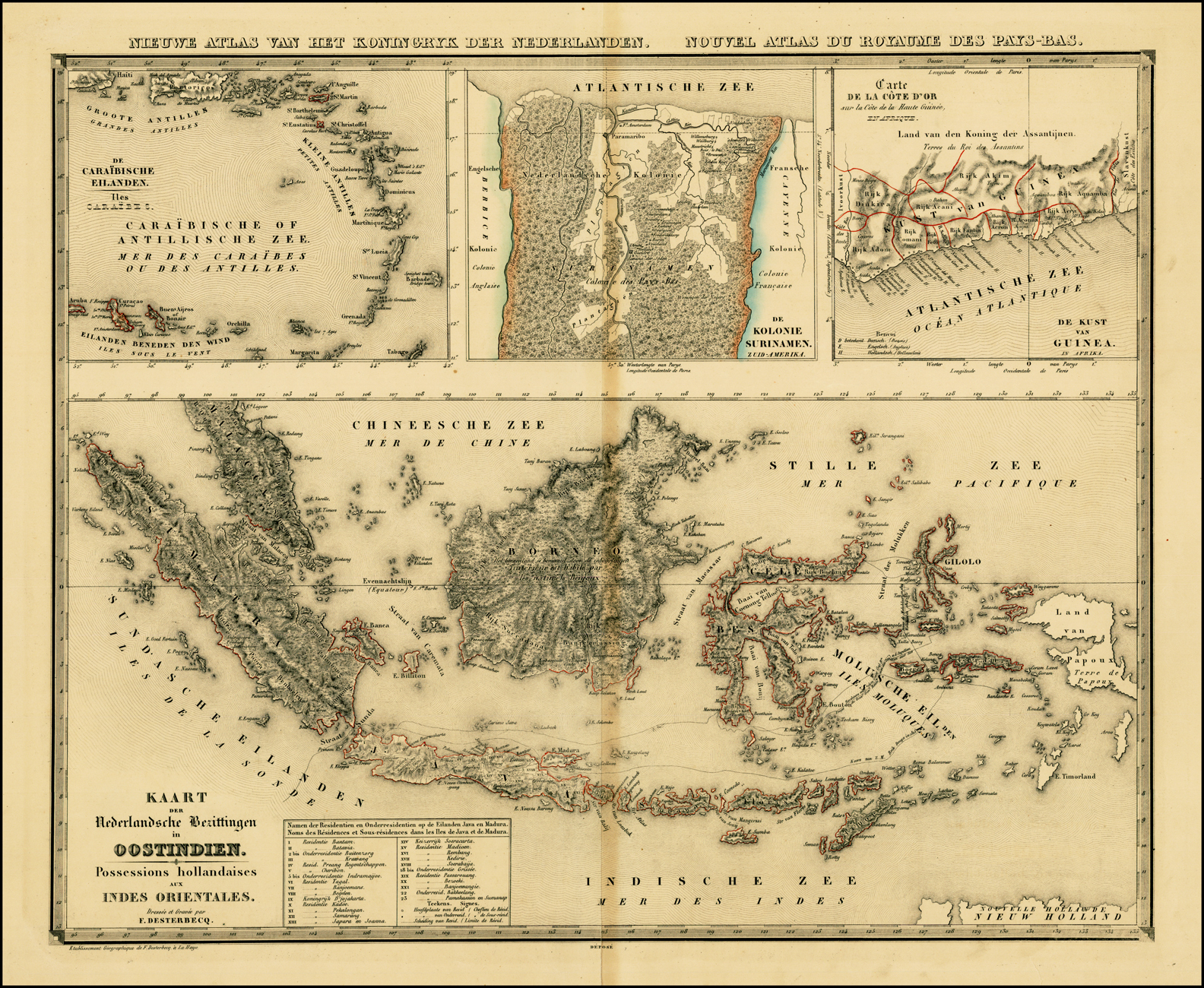