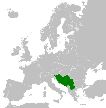
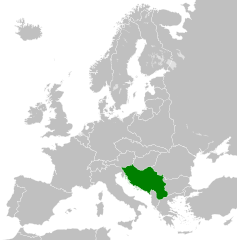
{{Information |Description ={{en|1=Map of the Kingdom of Yugoslavia circa 1930.}} |Source =Own work, based upon [http://commons.wikimedia.org/wiki/File:Weimar_Republic_1930.svg] |Author =25px '
A blank Map of Europe. Every country has an id which is its ISO-3166-1-ALPHA2 code in lower case.
Members of the EU have a class="eu", countries in europe (which I found turkey to be but russia not) have a class="europe". Certain countries are further subdivided the United Kingdom has gb-gbn for Great Britain and gb-nir for Northern Ireland. Russia is divided into ru-kgd for the Kaliningrad Oblast and ru-main for the Main body of Russia. There is the additional grouping #xb for the "British Islands" (the UK with its Crown Dependencies - Jersey, Guernsey and the Isle of Man) Contributors. Original Image: (http://commons.wikimedia.org/wiki/Image:Europe_countries.svg) Júlio Reis (http://commons.wikimedia.org/wiki/User:Tintazul). Recolouring and tagging with country codes: Marian "maix" Sigler (http://commons.wikimedia.org/wiki/User:Maix) Improved geographical features: http://commons.wikimedia.org/wiki/User:W!B: Updated to reflect dissolution of Serbia & Montenegro: http://commons.wikimedia.org/wiki/User:Zirland Updated to include British Crown Dependencies as seperate entities and regroup them as "British Islands", with some simplifications to the XML and CSS: James Hardy (http://commons.wikimedia.org/wiki/User:MrWeeble)
ไฟล, kingdom, yugoslavia, 1930, ไฟล, ประว, ไฟล, หน, าท, ภาพน, การใช, ไฟล, วนกลาง, อม, ลเก, ยวก, บภาพขนาดของต, วอย, าง, ของไฟล, กเซล, ความละเอ, ยดอ, กเซล, กเซล, กเซล, กเซล, กเซล, ภาพท, ความละเอ, ยดส, งกว, 8206, ไฟล, กเซล, ขนาดไฟล, โลไบต, ปภาพหร, อไฟล, เส, ยงน, . ifl prawtiifl hnathimiphaphni karichiflswnklang khxmulekiywkbphaphkhnadkhxngtwxyang PNG nikhxngifl SVG ni 450 456 phikesl khwamlaexiydxun 237 240 phikesl 474 480 phikesl 758 768 phikesl 1 011 1 024 phikesl 2 021 2 048 phikesl duphaphthimikhwamlaexiydsungkwa 8206 ifl SVG 450 456 phikesl khnadifl 474 kiolibt rupphaphhruxiflesiyngni tnchbbxyuthi khxmmxns raylaexiyddanlang epnkhxkhwamthiaesdngphlcak ifltnchbbinkhxmmxns khxmmxnsepnewbistinokhrngkarsahrbekbrwbrwmsuxesri thi khunsamarthchwyid khaxthibayKingdom of Yugoslavia 1930 svg English Map of the Kingdom of Yugoslavia circa 1930 wnthi 11 thnwakhm ph s 2554 aehlngthima Own work based upon File Weimar Republic 1930 svg phusrangsrrkh TRAJAN 117 nbsp iflphaphkrafiksewketxrimidrabukartrwcody W3C nbsp ni srangkhunodyich nbsp Inkscape karxnuyat karichiflniihm iflnixyuphayitsyyaxnuyat khriexthifkhxmmxns aebbaesdngthima xnuyataebbediywkn 3 0 tnchbbkhunsamarth thicaaebngpn thicathasaena aeckcay aelasngngandngklawtxip thicaeriyberiyngihm thicaddaeplngngandngklaw phayitenguxnikhtxipni aesdngthima khuntxngihekiyrtiecakhxngnganxyangehmaasm odyephimlingkipyngsyyaxnuyat aelarabuhakmikarepliynaeplng khunxacthaechnniidinrupaebbidkidtamkhwr aettxngimichinlksnathiaenawaphuihxnuyatsnbsnunkhunhruxkarichngankhxngkhun xnuyataebbediywkn hakkhunddaeplng epliynrup hruxtxetimnganni khuntxngichsyyaxnuyataebbediywknhruxaebbthiehmuxnkbsyyaxnuyatthiichkbnganniethannhttps creativecommons org licenses by sa 3 0 CC BY SA 3 0 Creative Commons Attribution Share Alike 3 0 true true AnnotationsInfoFieldThis image is annotated View the annotations at Commons229 312 90 70 450 456 Korolevstvo YugoslaviyakhabrryayodyyxithyephimkhabrryaythrrthdediywephuxkhyaykhwamwaiflnimixairxngkvsMap of the Kingdom of Yugoslavia circa 1930 ixethmthiaesdngxyuiniflniprakxbdwyyuokslaewiyaephnthisthanalikhsiththimilikhsiththisyyaxnuyatCreative Commons Attribution ShareAlike 3 0 Unported nbsp xngkvswnthisrang wnkxtng11 thnwakhm 2011 prawtiifl khlikwnthi ewlaephuxduiflthipraktinkhnann wnthi ewlarupyxkhnadphuichkhwamehn pccubn15 09 12 singhakhm 2556450 456 474 kiolibt AlphathonFixed Yugoslav Hungarian border and Dutch polders see main file 02 39 12 thnwakhm 2554450 456 461 kiolibt TRAJAN 117 Information Description en 1 Map of the Kingdom of Yugoslavia circa 1930 Source Own work based upon http commons wikimedia org wiki File Weimar Republic 1930 svg Author 25px 039 hnathimiphaphni hnatxipni oyngmathiphaphni rachxanackryuokslaewiy karichiflswnklang wikixuntxipniichiflni karichbn arz wikipedia org مملكة يوجوسلاڤيا karichbn ast wikipedia org Reinu de los Serbios Croates y Eslovenos Reinu de Yugoslavia karichbn azb wikipedia org یوقوسلاوی شاهلیغی karichbn az wikipedia org Yuqoslaviya kralligi karichbn ba wikipedia org Yugoslaviya korollege karichbn bg wikipedia org Kralstvo Yugoslaviya karichbn bs wikipedia org Kraljevina Jugoslavija karichbn ca wikipedia org Regne dels Serbis Croats i Eslovens karichbn cs wikipedia org Kralovstvi Jugoslavie karichbn da wikipedia org Kongeriget Jugoslavien karichbn de wikipedia org Konigreich Jugoslawien Diskussion Konigreich Serbien karichbn el wikipedia org Basileio ths Gioygkoslabias karichbn en wikipedia org Kingdom of Yugoslavia 1st Army Kingdom of Yugoslavia Creation of Yugoslavia 1st Army Group Kingdom of Yugoslavia 2nd Army Group Kingdom of Yugoslavia 2nd Army Kingdom of Yugoslavia 4th Army Kingdom of Yugoslavia 5th Army Kingdom of Yugoslavia 7th Army Kingdom of Yugoslavia 42nd Infantry Division Murska 40th Infantry Division Slavonska 27th Infantry Division Savska 32nd Infantry Division Triglavski 1st Cavalry Division Kingdom of Yugoslavia 38th Infantry Division Dravska User Falcaorib Germany Yugoslavia relations User Ditto voltorb sandbox karichbn en wiktionary org Dienvidslavijas Karaliste karichbn eo wikipedia org Regno Jugoslavio Jugoslavoj karichbn es wikipedia org Reino de los Serbios Croatas y Eslovenos Reino de Yugoslavia karichbn et wikipedia org Jugoslaavia Kuningriik karichbn eu wikipedia org Jugoslaviako Erresuma karichbn fa wikipedia org پادشاهی یوگسلاوی karichbn fi wikipedia org Jugoslavian kuningaskunta karichbn fr wikipedia org Royaume de Yougoslavie Royaume des Serbes Croates et Slovenes karichbn gl wikipedia org Reino de Iugoslavia karichbn he wikipedia org ממלכת יוגוסלביה karichbn hr wikipedia org Kraljevina Jugoslavija karichbn hu wikipedia org Jugoszlav Kiralysag karichbn hy wikipedia org Հարավսլավիայի թագավորություն karichbn id wikipedia org Kerajaan Yugoslavia karichbn it wikipedia org Regno di Jugoslavia dukarichthwolkephimetimkhxngiflnikhxmulekiywkbphaph phaphnimikhxmulephimetim sungswnihymacakklxngdicitxlhruxsaeknenxrthisamarthekbkhxmuldngklawiwrwmkbphaphid thaphaphnithukprbprungaekikhhruxepliynaeplngcakedim khxmulbangxyangcayngkhngimepliynaeplngehmuxnphaphthithukprbprungaekikhnnchuxeruxngsnCountries of EuropechuxphaphA blank Map of Europe Every country has an id which is its ISO 3166 1 ALPHA2 code in lower case Members of the EU have a class eu countries in europe which I found turkey to be but russia not have a class europe Certain countries are further subdivided the United Kingdom has gb gbn for Great Britain and gb nir for Northern Ireland Russia is divided into ru kgd for the Kaliningrad Oblast and ru main for the Main body of Russia There is the additional grouping xb for the British Islands the UK with its Crown Dependencies Jersey Guernsey and the Isle of Man Contributors Original Image http commons wikimedia org wiki Image Europe countries svg Julio Reis http commons wikimedia org wiki User Tintazul Recolouring and tagging with country codes Marian maix Sigler http commons wikimedia org wiki User Maix Improved geographical features http commons wikimedia org wiki User W B Updated to reflect dissolution of Serbia amp Montenegro http commons wikimedia org wiki User Zirland Updated to include British Crown Dependencies as seperate entities and regroup them as British Islands with some simplifications to the XML and CSS James Hardy http commons wikimedia org wiki User MrWeeble Released under CreativeCommons Attribution ShareAlike http creativecommons org licenses by sa 2 5 khwamkwang450khwamsung456 ekhathungcak https th wikipedia org wiki ifl Kingdom of Yugoslavia 1930 svg, wikipedia, วิกิ หนังสือ, หนังสือ, ห้องสมุด,