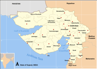
ไฟล, gujarat, state, districts, ไฟล, ประว, ไฟล, หน, าท, ภาพน, การใช, ไฟล, วนกลาง, อม, ลเก, ยวก, บภาพขนาดของต, วอย, างน, กเซล, ความละเอ, ยดอ, กเซล, กเซล, กเซล, ภาพท, ความละเอ, ยดส, งกว, 8206, กเซล, ขนาดไฟล, โลไบต, ชน, ดไมม, image, ปภาพหร, อไฟล, เส, ยงน, นฉบ, บอ. ifl prawtiifl hnathimiphaphni karichiflswnklang khxmulekiywkbphaphkhnadkhxngtwxyangni 800 566 phikesl khwamlaexiydxun 320 227 phikesl 640 453 phikesl 1 058 749 phikesl duphaphthimikhwamlaexiydsungkwa 8206 1 058 749 phikesl khnadifl 65 kiolibt chnidimm image png rupphaphhruxiflesiyngni tnchbbxyuthi khxmmxns raylaexiyddanlang epnkhxkhwamthiaesdngphlcak ifltnchbbinkhxmmxns khxmmxnsepnewbistinokhrngkarsahrbekbrwbrwmsuxesri thi khunsamarthchwyid This file requires updating because 7 new districts were created in January 2013 In doing so you could add a timestamp to the file Please notify the uploader with code subst update note 1 File Map Gujarat state and districts png 2 7 new districts were created in January 2013 code khwamyx Gujarat State India with district boundries and city marks Self Made w User Miljoshi December 2005Note co ordinates are estimated and may not be exactly accurate karxnuyatichsiththi khapheca inthanaphuthuxlikhsiththikhxngphaphhruxsuxni xnuyatihichphaphhruxsuxniphayitenguxnikhtxipni xnuyatihkhdlxk aeckcayaela hruxddaeprexksarniphayitenguxnikhkhxngsyyaxnuyatexksaresrikhxngknu run 1 2 hruxrunid nbcaknithixxkodymulnithisxftaewresri odyimmiswnidhamaekikh immikhxkhwampkhnaaelapkhlng saenakhxngsyyaxnuyatrwmxyuinswnchux syyaxnuyatexksaresrikhxngknuhttp www gnu org copyleft fdl html GFDL GNU Free Documentation License true trueiflnixyuphayitsyyaxnuyat khriexthifkhxmmxns aebbaesdngthima xnuyataebbediywkn 3 0 tnchbbkhunsamarth thicaaebngpn thicathasaena aeckcay aelasngngandngklawtxip thicaeriyberiyngihm thicaddaeplngngandngklaw phayitenguxnikhtxipni aesdngthima khuntxngihekiyrtiecakhxngnganxyangehmaasm odyephimlingkipyngsyyaxnuyat aelarabuhakmikarepliynaeplng khunxacthaechnniidinrupaebbidkidtamkhwr aettxngimichinlksnathiaenawaphuihxnuyatsnbsnunkhunhruxkarichngankhxngkhun xnuyataebbediywkn hakkhunddaeplng epliynrup hruxtxetimnganni khuntxngichsyyaxnuyataebbediywknhruxaebbthiehmuxnkbsyyaxnuyatthiichkbnganniethannpayaesdngsthanalikhsiththinithukephimephuxihepniptamkarepliynaeplngsyyaxnuyatkhxngmulnithiwikimiediy cak GFDL ipyng GFDL khwbkhukb CC BY SA 3 0 http creativecommons org licenses by sa 3 0 CC BY SA 3 0 Creative Commons Attribution Share Alike 3 0 true trueiflnixyuphayitsyyaxnuyatkhriexthifkhxmmxns runaesdngthima xnuyataebbediywkn 2 5 thwip 2 0 thwip aela 1 0 thwipkhunsamarth thicaaebngpn thicathasaena aeckcay aelasngngandngklawtxip thicaeriyberiyngihm thicaddaeplngngandngklaw phayitenguxnikhtxipni aesdngthima khuntxngihekiyrtiecakhxngnganxyangehmaasm odyephimlingkipyngsyyaxnuyat aelarabuhakmikarepliynaeplng khunxacthaechnniidinrupaebbidkidtamkhwr aettxngimichinlksnathiaenawaphuihxnuyatsnbsnunkhunhruxkarichngankhxngkhun xnuyataebbediywkn hakkhunddaeplng epliynrup hruxtxetimnganni khuntxngichsyyaxnuyataebbediywknhruxaebbthiehmuxnkbsyyaxnuyatthiichkbnganniethannhttps creativecommons org licenses by sa 2 5 CC BY SA 2 5 Creative Commons Attribution Share Alike 2 5 true truekhunsamartheluxksyyaxnuyatdngklawtamtxngkarkhabrryayodyyxithyephimkhabrryaythrrthdediywephuxkhyaykhwamwaiflnimixairixethmthiaesdngxyuiniflniprakxbdwysthanalikhsiththimilikhsiththisyyaxnuyatCreative Commons Attribution ShareAlike 3 0 Unported xngkvsCreative Commons Attribution ShareAlike 2 5 Generic xngkvsGNU Free Documentation License version 1 2 or later xngkvsCreative Commons Attribution ShareAlike 2 0 Generic xngkvsCreative Commons Attribution ShareAlike 1 0 Generic xngkvs prawtiifl khlikwnthi ewlaephuxduiflthipraktinkhnann wnthi ewlarupyxkhnadphuichkhwamehn pccubn18 42 29 thnwakhm 25481 058 749 65 kiolibt MiljoshiGujarat State India with district boundries Self Made Miljoshi December 2005 hnathimiphaphni immihnaidoyngmathiphaphnikarichiflswnklang wikixuntxipniichiflni karichbn an wikipedia org Gucharat karichbn bn wikipedia org কল পস র প রকল প karichbn ca wikipedia org Districte d Ahmedabad Districte d Amreli Districte de Baroda Districte de Bharuch Districte d Anand Districte de Kheda Districte de Panchmahal Districte de Surat Plantilla Gujarat karichbn da wikipedia org Gujarat karichbn en wikipedia org Bhuj Anjar Gujarat Kalpasar Project karichbn fr wikipedia org Gujarat karichbn hi wikipedia org कल पसर पर य जन karichbn hr wikipedia org Daman i Diu karichbn hu wikipedia org Gudzsarat karichbn nn wikipedia org Gujarat karichbn no wikipedia org Gujarat karichbn or wikipedia org ପ ରବନ ଦର ଛ ଞ ଚ ଗ ଜର ଟ ଭଦ ଦର ଜ ଲ ଲ କଡ ଗ ଜର ଟ ମହ ଆ ନଡ ଆଦ ପ ଟ ଲ ଦ ସ ବରକ ଣ ଡଲ karichbn pam wikipedia org Bhuj karichbn pl wiktionary org Zatoka Kambajska karichbn sa wikipedia org ग जर त भ ष karichbn sh wikipedia org Gujarat karichbn sr wikipedia org Guџarat karichbn ta wikipedia org கல பச ர அண க கட ட karichbn ta wiktionary org க ர ஜரம karichbn te wikipedia org ప ర బ దర వడ దర అహ మద బ ద జ న గఢ స రత మ స గ జర త ల న జ ల ల ల అమ ర ల బనస క త భ ర చ ద హ ద డ గ స గ ధ నగర జ మ నగర కఛ జ ల ల dukarichthwolkephimetimkhxngiflnikhxmulekiywkbphaph phaphnimikhxmulephimetim sungswnihymacakklxngdicitxlhruxsaeknenxrthisamarthekbkhxmuldngklawiwrwmkbphaphid thaphaphnithukprbprungaekikhhruxepliynaeplngcakedim khxmulbangxyangcayngkhngimepliynaeplngehmuxnphaphthithukprbprungaekikhnnsxftaewrthiichAdobe ImageReady ekhathungcak https th wikipedia org wiki ifl Map Gujarat state and districts png, wikipedia, วิกิ หนังสือ, หนังสือ, ห้องสมุด,