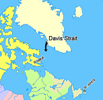
Map indicating Davis Strait, lying between Nunavut, Canada and Greenland. {{legend|#ffff66|Nunavut}} {{legend|#d5fe94|Quebec}} {{legend|#ecebb6|Newfoundland and Labrador}} {{legend|#ffffcc|Regions outside Canada (Greenland, Iceland)}}
ไฟล, indicating, davis, strait, ไฟล, ประว, ไฟล, หน, าท, ภาพน, การใช, ไฟล, วนกลางไม, ภาพท, รายละเอ, ยดส, งกว, าน, indicating, davis, strait, 8206, กเซล, ขนาดไฟล, โลไบต, ชน, ดไมม, image, ปภาพหร, อไฟล, เส, ยงน, นฉบ, บอย, คอมมอนส, รายละเอ, ยดด, านล, าง, เป, นข, อค. ifl prawtiifl hnathimiphaphni karichiflswnklangimmiphaphthimiraylaexiydsungkwani Map indicating Davis Strait png 8206 340 330 phikesl khnadifl 47 kiolibt chnidimm image png rupphaphhruxiflesiyngni tnchbbxyuthi khxmmxns raylaexiyddanlang epnkhxkhwamthiaesdngphlcak ifltnchbbinkhxmmxns khxmmxnsepnewbistinokhrngkarsahrbekbrwbrwmsuxesri thi khunsamarthchwyid khwamyx Map indicating Davis Strait lying between Greenland and Nunavut Canada Nunavut Quebec Newfoundland and Labrador Regions outside Canada Greenland Iceland c Her Majesty the Queen in Right of Canada Department of Natural Resources All rights reserved Licence Agreement karxnuyatichsiththi phuthuxlikhsiththikhxngphlnganni xnuyatihnaphlnganniipichid inthukwtthuprasngkh odyimcakdenguxnikhdankarthasa karnaipichephuxkarkha aelakarddaeplngaekikhphlnganni hmayehtuhakrupphaphnicaepntxngrabuchuxphusrangsrrkhphlngan krunaich Attribution aethn hakrupphaphniepnkhxngthanexng krunaich PD self aethn Copyrighted free use commons wikimedia org wiki File Map indicating Davis Strait pngkhabrryayodyyxithyephimkhabrryaythrrthdediywephuxkhyaykhwamwaiflnimixairxngkvsLocation map of Davis Straitixethmthiaesdngxyuiniflniprakxbdwychxngaekhbedwissthanalikhsiththimilikhsiththisyyaxnuyatcopyrighted free use xngkvs prawtiifl khlikwnthi ewlaephuxduiflthipraktinkhnann wnthi ewlarupyxkhnadphuichkhwamehn pccubn18 08 21 minakhm 2549340 330 47 kiolibt David Kernow commonswikiMap indicating Davis Strait lying between Nunavut Canada and Greenland legend ffff66 Nunavut legend d5fe94 Quebec legend ecebb6 Newfoundland and Labrador legend ffffcc Regions outside Canada Greenland Iceland hnathimiphaphni hnatxipni oyngmathiphaphni chxngaekhbedwis karichiflswnklang wikixuntxipniichiflni karichbn be wikipedia org Praliy Devisa karichbn bg wikipedia org Dejvis protok karichbn bn wikipedia org ড ভ স প রণ ল karichbn bs wikipedia org Davisov prolaz karichbn cs wikipedia org Davisuv pruliv karichbn da wikipedia org Davisstraedet karichbn de wikipedia org Davisstrasse karichbn el wikipedia org Por8mos toy Nteibis karichbn en wikipedia org Davis Strait karichbn eo wikipedia org Davisa Markolo karichbn fi wikipedia org Davisinsalmi karichbn fy wikipedia org Strjitte Davis karichbn he wikipedia org מצר דייוויס karichbn hr wikipedia org Davisov prolaz karichbn id wikipedia org Selat Davis karichbn is wikipedia org Davis sund karichbn it wikipedia org Stretto di Davis karichbn ja wikipedia org デービス海峡 利用者 Nazki rhetorica sandbox karichbn ko wikipedia org 데이비스 해협 karichbn ku wikipedia org Tengava Davis karichbn la wikipedia org Fretum Davisianum karichbn lt wikipedia org Deiviso sasiauris karichbn ml wikipedia org ഡ വ സ കടല ട ക ക karichbn nn wikipedia org Davissundet karichbn pa wikipedia org ਡ ਵ ਸ ਪਣਜ ੜ karichbn pl wikipedia org Ciesnina Davisa karichbn pnb wikipedia org آبنائے ڈیوس karichbn pt wikipedia org Estreito de Davis karichbn ro wikipedia org Stramtoarea Davis karichbn sh wikipedia org Davisov prolaz karichbn simple wikipedia org Davis Strait karichbn sk wikipedia org Davisov prieliv karichbn sr wikipedia org Deјvisov moreuz karichbn sv wikipedia org Davis sund karichbn sw wikipedia org Mlangobahari wa Davis karichbn tr wikipedia org Davis Bogazi karichbn uk wikipedia org Dejvisova protoka karichbn ur wikipedia org آبنائے ڈیوس karichbn vi wikipedia org Eo biển Davis karichbn war wikipedia org Sulang ni Davis karichbn xmf wikipedia org დევისიშ საროტი karichbn zh min nan wikipedia org Davis Hai kiap ekhathungcak https th wikipedia org wiki ifl Map indicating Davis Strait png, wikipedia, วิกิ หนังสือ, หนังสือ, ห้องสมุด,