The original description page was here. All following user names refer to en.wikipedia.
วันที่/เวลา
ขนาด
ผู้ใช้
ความเห็น
2016-06-21 15:17:32
1013× 643×
Giorgi Balakhadze
fix
2016-06-21 15:12:26
1013× 643×
Giorgi Balakhadze
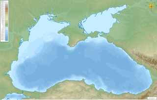
{{Information |Description={{en|Map of the [[Black Sea]] with bathymetry and surrounding relief.}} </br>Mercator projection. Geographic limits of the map: * N: 47.594° N * S: 40.548° N * W: 26.825° E * E: 42.242° E *SRTM WED 3-arc second *ETOPO1 Be...
ไฟล, black, with, bathymetry, surrounding, relief, ไฟล, ประว, ไฟล, หน, าท, ภาพน, การใช, ไฟล, วนกลาง, อม, ลเก, ยวก, บภาพขนาดของต, วอย, าง, ของไฟล, กเซล, ความละเอ, ยดอ, กเซล, กเซล, กเซล, กเซล, กเซล, กเซล, ภาพท, ความละเอ, ยดส, งกว, 8206, ไฟล, กเซล, ขนาดไฟล, เมกะไ. ifl prawtiifl hnathimiphaphni karichiflswnklang khxmulekiywkbphaphkhnadkhxngtwxyang PNG nikhxngifl SVG ni 800 508 phikesl khwamlaexiydxun 320 203 phikesl 640 406 phikesl 1 024 650 phikesl 1 280 812 phikesl 2 560 1 625 phikesl 1 013 643 phikesl duphaphthimikhwamlaexiydsungkwa 8206 ifl SVG 1 013 643 phikesl khnadifl 8 35 emkaibt rupphaphhruxiflesiyngni tnchbbxyuthi khxmmxns raylaexiyddanlang epnkhxkhwamthiaesdngphlcak ifltnchbbinkhxmmxns khxmmxnsepnewbistinokhrngkarsahrbekbrwbrwmsuxesri thi khunsamarthchwyid khwamyx khaxthibayMap of the Black Sea with bathymetry and surrounding relief svg English Map of the w Black Sea with bathymetry and surrounding relief ქართული შავი ზღვის რუკა სიღრმის მაჩვენებლებითა და მიდამოების რელიეფით Mercator projection Geographic limits of the map N 47 594 N S 40 548 N W 26 825 E E 42 242 E SRTM WED 3 arc second ETOPO1 Bedrockwnthi 21 mithunayn ph s 2559aehlngthima ngankhxngtwphusrangsrrkh Giorgi Balakhadze karxnuyatichsiththi Giorgi Balakhadze thi wikiphiediyphasaxngkvs inthanaphuthuxlikhsiththikhxngphaphhruxsuxni xnuyatihichphaphhruxsuxniphayitenguxnikhtxipniiflnixyuphayitsyyaxnuyat khriexthifkhxmmxns aebbaesdngthima xnuyataebbediywkn 4 0 nanachatikaraesdngthima Giorgi Balakhadze thi wikiphiediyphasaxngkvskhunsamarth thicaaebngpn thicathasaena aeckcay aelasngngandngklawtxip thicaeriyberiyngihm thicaddaeplngngandngklaw phayitenguxnikhtxipni aesdngthima khuntxngihekiyrtiecakhxngnganxyangehmaasm odyephimlingkipyngsyyaxnuyat aelarabuhakmikarepliynaeplng khunxacthaechnniidinrupaebbidkidtamkhwr aettxngimichinlksnathiaenawaphuihxnuyatsnbsnunkhunhruxkarichngankhxngkhun xnuyataebbediywkn hakkhunddaeplng epliynrup hruxtxetimnganni khuntxngichsyyaxnuyataebbediywknhruxaebbthiehmuxnkbsyyaxnuyatthiichkbnganniethannhttps creativecommons org licenses by sa 4 0 CC BY SA 4 0 Creative Commons Attribution Share Alike 4 0 true true bnthukkarxphohld The original description page was here All following user names refer to en wikipedia wnthi ewla khnad phuich khwamehn2016 06 21 15 17 32 1013 643 Giorgi Balakhadze fix2016 06 21 15 12 26 1013 643 Giorgi Balakhadze Information Description en Map of the Black Sea with bathymetry and surrounding relief lt br gt Mercator projection Geographic limits of the map N 47 594 N S 40 548 N W 26 825 E E 42 242 E SRTM WED 3 arc second ETOPO1 Be khabrryayodyyxithyephimkhabrryaythrrthdediywephuxkhyaykhwamwaiflnimixairxngkvsThe Black SeaixethmthiaesdngxyuiniflniprakxbdwythaeldasthanalikhsiththimilikhsiththisyyaxnuyatCreative Commons Attribution ShareAlike 4 0 International xngkvswnthisrang wnkxtng21 mithunayn 2016thimakhxngiflkarsrangdngedimodyphuxpohld prawtiifl khlikwnthi ewlaephuxduiflthipraktinkhnann wnthi ewlarupyxkhnadphuichkhwamehn pccubn10 49 23 mithunayn 25591 013 643 8 35 emkaibt OgreBot BOT Reverting to most recent version before archival 10 49 23 mithunayn 25591 013 643 8 29 emkaibt OgreBot BOT Uploading old version of file from en wikipedia originally uploaded on 2016 06 21 15 12 26 by Giorgi Balakhadze 06 13 22 mithunayn 25591 013 643 8 35 emkaibt FastilyCloneTransferred from en wikipedia MTC hnathimiphaphni hnatxipni oyngmathiphaphni simeforpxl thaelda ekaangu thaelda karichiflswnklang wikixuntxipniichiflni karichbn ar wikipedia org ريزا تركيا نظرية طوفان البحر الأسود وحدة Location map data Black Sea وحدة Location map data Black Sea شرح karichbn azb wikipedia org ریزه سامسون قارا دنیز پرکوپ روسیه سوداک روسیه کاچا قیریم karichbn bh wikipedia org क ल स गर karichbn bn wikipedia org স ভ স ত প ল মড উল অবস থ ন ম নচ ত র উপ ত ত ক ষ ণ স গর মড উল অবস থ ন ম নচ ত র উপ ত ত ক ষ ণ স গর নথ সর প দ ব প ইউক র ন স মস ন karichbn da wiktionary org Sortehavet karichbn en wikipedia org Black Sea Trabzon Sea of Azov Burgas Varna Bulgaria Battle of Varna Sinop Turkey Snake Island Ukraine Krasnodar Kuban river Maykop Panticapaeum Samsun Simferopol Kastamonu Battle of Sinop Perekop Black Sea deluge hypothesis Sudak Rize Gelendzhik Gurzuf Tuapse Adapazari Pitsunda Ordu Battle of Tzirallum Battle of Mount Scorobas Siege of Varna Gorele Carsamba Unye Kackar Mountains dukarichthwolkephimetimkhxngiflnikhxmulekiywkbphaph phaphnimikhxmulephimetim sungswnihymacakklxngdicitxlhruxsaeknenxrthisamarthekbkhxmuldngklawiwrwmkbphaphid thaphaphnithukprbprungaekikhhruxepliynaeplngcakedim khxmulbangxyangcayngkhngimepliynaeplngehmuxnphaphthithukprbprungaekikhnnchuxeruxngsnBlack Sea bathymatry and surounding reliefkhwamkwang810 48828ptkhwamsung514 59277pt ekhathungcak https th wikipedia org wiki ifl Map of the Black Sea with bathymetry and surrounding relief svg, wikipedia, วิกิ หนังสือ, หนังสือ, ห้องสมุด,