คำอธิบายMap of the partition of the Kingdom of Poland and the Grand Duchy of Lithuania from 1799.jpg
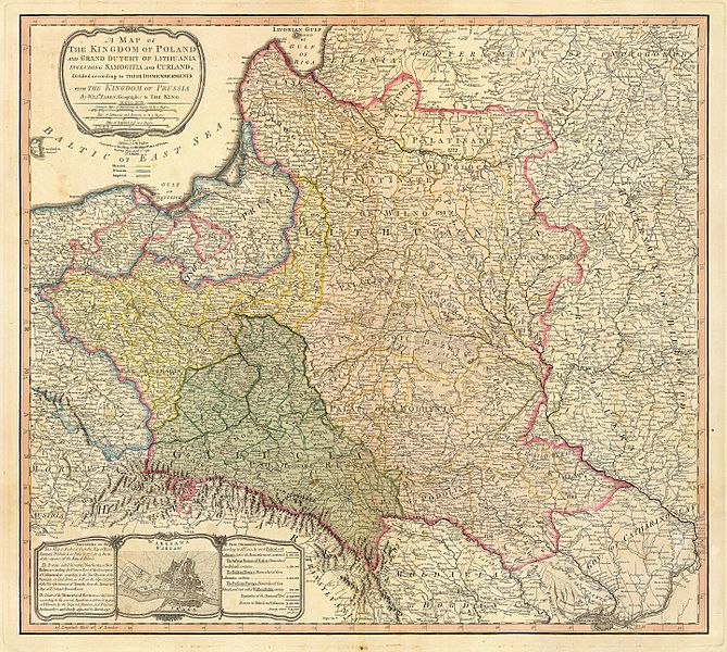
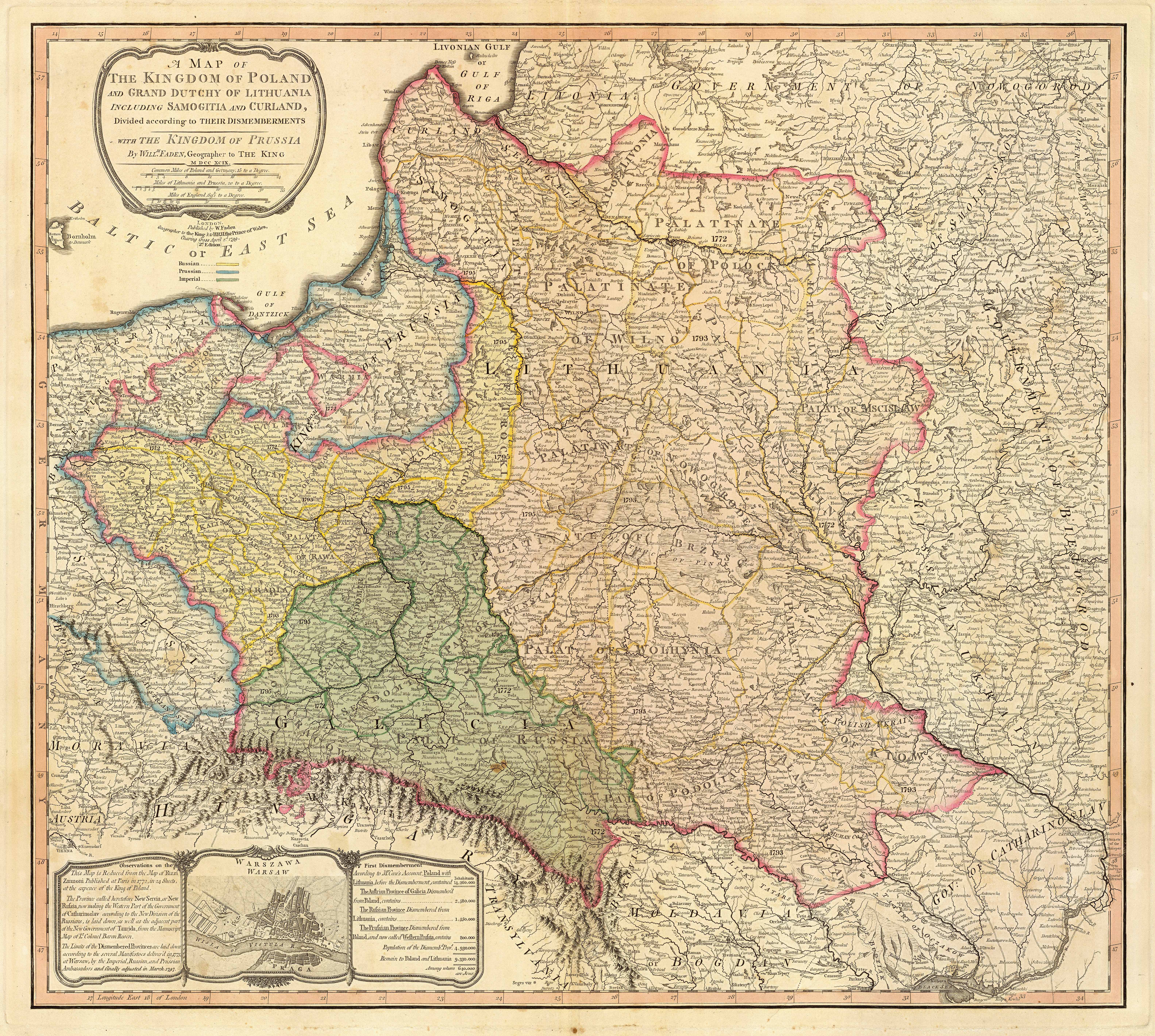
Title: "A map of the Kingdom of Poland and the Grand Duchy of Lithuania including Samogitia and Curland divided according to their dismemberments with the Kingdom of Prussia". A map from 1799 showing how the Polish-Lithuanian Commonwealth was partitioned in 1765-1795 between Prussia, Austria, and Russia. This is an extremely detailed map which lists all the cities and small towns and labels the regions according to their English names. The boundaries former Polish-Lithuanian Commonwealth colored light red. The areas taken by Prussia are colored yellow, those taken by Austria colored green, and those taken by Russia are colored beige. Prussia itself is bordered in blue. Eastern Pomerania and Warmia are shown as part of Prussia but bordered in red as well.
{{Information |Description=Title: "A map of the Kingdom of Poland and the Grand Duchy of Lithuania including Samogitia and Curland divided according to their dismemberments with the Kingdom of Prussia". A map from 1799 showing how the Polish-Lithuanian Co
ไฟล, partition, kingdom, poland, grand, duchy, lithuania, from, 1799, ไฟล, ประว, ไฟล, หน, าท, ภาพน, การใช, ไฟล, วนกลาง, อม, ลเก, ยวก, บภาพขนาดของต, วอย, างน, กเซล, ความละเอ, ยดอ, กเซล, กเซล, กเซล, กเซล, กเซล, กเซล, ภาพท, ความละเอ, ยดส, งกว, 8206, กเซล, ขนาดไฟล. ifl prawtiifl hnathimiphaphni karichiflswnklang khxmulekiywkbphaphkhnadkhxngtwxyangni 669 600 phikesl khwamlaexiydxun 268 240 phikesl 535 480 phikesl 856 768 phikesl 1 142 1 024 phikesl 2 284 2 048 phikesl 6 330 5 677 phikesl duphaphthimikhwamlaexiydsungkwa 8206 6 330 5 677 phikesl khnadifl 6 83 emkaibt chnidimm image jpeg rupphaphhruxiflesiyngni tnchbbxyuthi khxmmxns raylaexiyddanlang epnkhxkhwamthiaesdngphlcak ifltnchbbinkhxmmxns khxmmxnsepnewbistinokhrngkarsahrbekbrwbrwmsuxesri thi khunsamarthchwyid khwamyx khaxthibayMap of the partition of the Kingdom of Poland and the Grand Duchy of Lithuania from 1799 jpg Title A map of the Kingdom of Poland and the Grand Duchy of Lithuania including Samogitia and Curland divided according to their dismemberments with the Kingdom of Prussia A map from 1799 showing how the Polish Lithuanian Commonwealth was partitioned in 1765 1795 between Prussia Austria and Russia This is an extremely detailed map which lists all the cities and small towns and labels the regions according to their English names The boundaries former Polish Lithuanian Commonwealth colored light red The areas taken by Prussia are colored yellow those taken by Austria colored green and those taken by Russia are colored beige Prussia itself is bordered in blue Eastern Pomerania and Warmia are shown as part of Prussia but bordered in red as well wnthi 2 emsayn ph s 2342aehlngthima http www belarusguide com images maps Kokosha POlonia amp Lituania 1799 jpgphusrangsrrkh William Faden 1749 1836 chuxxun Faden amp Jefferyskhaxthibay British cartographer aela publisherwnekid wnesiychiwit circa 2292 hrux 2293 date QS P 1750 00 00T00 00 00Z 9 P1480 Q572790221 minakhm ph s 2379 sthanthiekid sthanthiesiychiwit lxndxnSheppertonsthanthisrangsrrkhngan From 1771 Geographer to the King and to the Prince of Wales ngankhwbkhumraykarhlkthan Q8008902 VIAF 12630020 ISNI 0000 0001 2276 5926 ULAN 500043295 Open Library OL871234A LCCN n80050360 WorldCat creator QS P170 Q8008902 karxnuyatichsiththi Public domain Public domain false falsenganniepnsatharnsmbti inpraethstnkaenidaelapraethsxun thirayaewlakarkhumkhrxnglikhsiththinxykwa 100 pihlngcakphusrangsrrkhnganesiychiwit nxkcaknikhunxactxngephimpaysatharnsmbtiinshrthxemrika ephuxrabuwaehtuidngannicungepnsatharnsmbtiinshrthxemrikaiflniidthukrabuwaimmikhxcakdphayitkdhmaylikhsiththi rwmthungsiththithiekiywkhxngaelathiiklekhiyngknhttps creativecommons org publicdomain mark 1 0 PDM Creative Commons Public Domain Mark 1 0 false falsekhabrryayodyyxithyephimkhabrryaythrrthdediywephuxkhyaykhwamwaiflnimixairixethmthiaesdngxyuiniflniprakxbdwywnthisrang wnkxtng2 emsayn 1799krikxeriyn prawtiifl khlikwnthi ewlaephuxduiflthipraktinkhnann wnthi ewlarupyxkhnadphuichkhwamehn pccubn12 04 23 knyayn 25506 330 5 677 6 83 emkaibt Archaeogenetics Information Description Title A map of the Kingdom of Poland and the Grand Duchy of Lithuania including Samogitia and Curland divided according to their dismemberments with the Kingdom of Prussia A map from 1799 showing how the Polish Lithuanian Co hnathimiphaphni hnatxipni oyngmathiphaphni karaebngopaelnd karichiflswnklang wikixuntxipniichiflni karichbn en wikipedia org Partitions of Poland Haplogroup G M377 karichbn et wikipedia org Kolmas Poola jagamine Rzeczpospolita Poola ajalugu karichbn lt wikipedia org Naudotojas CD 1799 William Faden karichbn pnb wikipedia org پولینڈ دیاں ونڈاں karichbn uk wikipedia org Teofipol karichbn ur wikipedia org پولینڈ کی تقسیماتkhxmulekiywkbphaph phaphnimikhxmulephimetim sungswnihymacakklxngdicitxlhruxsaeknenxrthisamarthekbkhxmuldngklawiwrwmkbphaphid thaphaphnithukprbprungaekikhhruxepliynaeplngcakedim khxmulbangxyangcayngkhngimepliynaeplngehmuxnphaphthithukprbprungaekikhnnkarcdwangphaphpktikhwamlaexiydaenwnxn254 dpikhwamlaexiydaenwtng254 dpisxftaewrthiichAdobe Photoshop CS Windowsaekikhphaphlasud16 41 22 singhakhm 2549sepssiimidprbethiyb ekhathungcak https th wikipedia org wiki ifl Map of the partition of the Kingdom of Poland and the Grand Duchy of Lithuania from 1799 jpg, wikipedia, วิกิ หนังสือ, หนังสือ, ห้องสมุด,