000_Etiopia_harta.PNG: CIA World Factbook and User:Hipi Zhdripi
Africa 1909, Edward Hertslet (Horn of Africa, detail).jpg: Sir Edward Hertslet
derivative work: Pethrus (talk)
derivative work: Pethrus (talk)
Français : Cette carte a été créée par Pethrus d'après les sources mentionnés ci-dessus. Il s'agit d'un travail d'amateur, même s'il a été réalisé avec soin ; il peut comporter des inexactitudes ou des erreurs. Cette carte a donc un rôle d'illustration et non de référence. N'hésitez pas à me signaler toute erreur que vous constateriez ou à effectuer vous-même la correction.
English: This map was drawn by Pethrus from sources mentionned above. Even if it was done with care, this is an amateur work ; there might be some inaccuracies or errors. As such, it should not be considered authoritative. Please contact me if you notice any mistake, and feel free to correct it yourself.
This map was improved or created by the Wikigraphists of the Graphic Lab (fr). You can propose images to clean up, improve, create or translate as well.
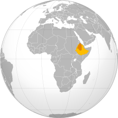
2010-03-15T14:02:09Z Pethrus 772x705 (17951 Bytes) {{Information |Description={{en|Ethiopian Empire's territorial expansion during Menelik II reign. {{legend|#deca60|Ethiopian Empire before conquests}}{{legend|#f5b46f|Ethiopian Empire after conquests}}}} {{fr|1=Expansion ter
{{Information |Description={{en|Ethiopian Empire's territorial expansion during Menelik II reign. {{legend|#deca60|Ethiopian Empire before conquests}}{{legend|#c95e08|Ethiopian Empire after conquests}}}} {{fr|1=Expansion territoriale de l'empire éthiopi
ไฟล, menelik, conquests, world, sphere, ไฟล, ประว, ไฟล, หน, าท, ภาพน, การใช, ไฟล, วนกลางขนาดของต, วอย, าง, ของไฟล, กเซล, ความละเอ, ยดอ, กเซล, กเซล, กเซล, กเซล, กเซล, ภาพท, ความละเอ, ยดส, งกว, 8206, ไฟล, กเซล, ขนาดไฟล, โลไบต, ปภาพหร, อไฟล, เส, ยงน, นฉบ, บอย, คอ. ifl prawtiifl hnathimiphaphni karichiflswnklangkhnadkhxngtwxyang PNG nikhxngifl SVG ni 550 550 phikesl khwamlaexiydxun 240 240 phikesl 480 480 phikesl 768 768 phikesl 1 024 1 024 phikesl 2 048 2 048 phikesl duphaphthimikhwamlaexiydsungkwa 8206 ifl SVG 550 550 phikesl khnadifl 134 kiolibt rupphaphhruxiflesiyngni tnchbbxyuthi khxmmxns raylaexiyddanlang epnkhxkhwamthiaesdngphlcak ifltnchbbinkhxmmxns khxmmxnsepnewbistinokhrngkarsahrbekbrwbrwmsuxesri thi khunsamarthchwyid khaxthibayMenelik II conquests map on world sphere svg English Ethiopian Empire s territorial expansion during Menelik II reign Ethiopian Empire before conquests Ethiopian Empire after conquests Francais Expansion territoriale de l empire ethiopien durant le regne de Menelik II Empire ethiopien avant les conquetes Empire ethiopien apres les conqueteswnthi 1 mkrakhm ph s 2453 17 27 UTC aehlngthima Africa orthographic projection svg Menelik II conquests map svgphusrangsrrkh Africa orthographic projection svg Martin23230 Menelik II conquests map svg Conquetes de Menelik II png Vob08 000 Etiopia harta PNG CIA World Factbook and User Hipi Zhdripi Africa 1909 Edward Hertslet Horn of Africa detail jpg Sir Edward Hertslet derivative work Pethrus talk derivative work Pethrus talk Francais Cette carte a ete creee par Pethrus d apres les sources mentionnes ci dessus Il s agit d un travail d amateur meme s il a ete realise avec soin il peut comporter des inexactitudes ou des erreurs Cette carte a donc un role d illustration et non de reference N hesitez pas a me signaler toute erreur que vous constateriez ou a effectuer vous meme la correction English This map was drawn by Pethrus from sources mentionned above Even if it was done with care this is an amateur work there might be some inaccuracies or errors As such it should not be considered authoritative Please contact me if you notice any mistake and feel free to correct it yourself This map was improved or created by the Wikigraphists of the Graphic Lab fr You can propose images to clean up improve create or translate as well xnuyatihkhdlxk aeckcayaela hruxddaeprexksarniphayitenguxnikhkhxngsyyaxnuyatexksaresrikhxngknu run 1 2 hruxrunid nbcaknithixxkodymulnithisxftaewresri odyimmiswnidhamaekikh immikhxkhwampkhnaaelapkhlng saenakhxngsyyaxnuyatrwmxyuinswnchux syyaxnuyatexksaresrikhxngknuhttp www gnu org copyleft fdl html GFDL GNU Free Documentation License true trueiflnixyuphayitsyyaxnuyat khriexthifkhxmmxns aebbaesdngthima xnuyataebbediywkn 3 0 tnchbbkhunsamarth thicaaebngpn thicathasaena aeckcay aelasngngandngklawtxip thicaeriyberiyngihm thicaddaeplngngandngklaw phayitenguxnikhtxipni aesdngthima khuntxngihekiyrtiecakhxngnganxyangehmaasm odyephimlingkipyngsyyaxnuyat aelarabuhakmikarepliynaeplng khunxacthaechnniidinrupaebbidkidtamkhwr aettxngimichinlksnathiaenawaphuihxnuyatsnbsnunkhunhruxkarichngankhxngkhun xnuyataebbediywkn hakkhunddaeplng epliynrup hruxtxetimnganni khuntxngichsyyaxnuyataebbediywknhruxaebbthiehmuxnkbsyyaxnuyatthiichkbnganniethannhttps creativecommons org licenses by sa 3 0 CC BY SA 3 0 Creative Commons Attribution Share Alike 3 0 true true bnthukkarxphohld This image is a derivative work of the following images File Africa orthographic projection svg licensed with Cc by sa 3 0 GFDL 2009 12 26T12 16 07Z Semhur 550x550 134838 Bytes border Eritrea Etiophia 2009 12 05T05 13 01Z Keepscases 550x550 327726 Bytes borders 2009 06 25T11 35 40Z Martin23230 541x541 333490 Bytes Information Description en 1 Orthographic map of Africa Source Own work by uploader Author User Martin23230 Martin23230 Date 2009 06 25 Permission other versions Category Orthographic projections File Menelik II conquests map svg licensed with GFDL 2010 03 15T15 36 06Z Pethrus 772x705 831590 Bytes Borders fixes background topographic image fix 2010 03 15T14 02 09Z Pethrus 772x705 17951 Bytes Information Description en Ethiopian Empire s territorial expansion during Menelik II reign legend deca60 Ethiopian Empire before conquests legend f5b46f Ethiopian Empire after conquests fr 1 Expansion terUploaded with derivativeFXkhabrryayodyyxithyephimkhabrryaythrrthdediywephuxkhyaykhwamwaiflnimixairixethmthiaesdngxyuiniflniprakxbdwysthanalikhsiththimilikhsiththisyyaxnuyatGNU Free Documentation License version 1 2 or later xngkvsCreative Commons Attribution ShareAlike 3 0 Unported xngkvswnthisrang wnkxtng15 minakhm 2010 prawtiifl khlikwnthi ewlaephuxduiflthipraktinkhnann wnthi ewlarupyxkhnadphuichkhwamehn pccubn00 28 16 minakhm 2553550 550 134 kiolibt Pethrus Information Description en Ethiopian Empire 039 s territorial expansion during Menelik II reign legend deca60 Ethiopian Empire before conquests legend c95e08 Ethiopian Empire after conquests fr 1 Expansion territoriale de l 039 empire ethiopi hnathimiphaphni hnatxipni oyngmathiphaphni ckrwrrdiexthioxepiy karichiflswnklang wikixuntxipniichiflni karichbn af wikipedia org Keiserryk Ethiopie karichbn az wikipedia org Efiopiya imperiyasi karichbn bg wikipedia org Etiopska imperiya karichbn cv wikipedia org Efiopi imperijӗ karichbn de wikipedia org Menelik II karichbn en wikipedia org Ethiopian Empire List of conflicts in Ethiopia Menelik s Expansions karichbn fr wikipedia org Empire ethiopien Wikipedia Atelier graphique Cartes Archives mars 2010 karichbn he wikipedia org האימפריה האתיופית karichbn id wikipedia org Kekaisaran Etiopia karichbn ko wikipedia org 에티오피아 제국 karichbn om wikipedia org Impaayera Itoophiyaa karichbn ru wikipedia org Efiopskaya imperiya karichbn sc wikipedia org Imperiu de Etiopia karichbn sd wikipedia org سلطنت ايٿوپيا karichbn simple wikipedia org Ethiopian Empire karichbn sr wikipedia org Etiopsko carstvo karichbn ta wikipedia org எத த ய ப ப யப ப ரரச karichbn tr wikipedia org Etiyopya Imparatorlugu karichbn uk wikipedia org Efiopska imperiya karichbn ur wikipedia org سلطنت ایتھوپیا karichbn www wikidata org Q207521 karichbn xmf wikipedia org ეთიოპიაშ იმპერია ekhathungcak https th wikipedia org wiki ifl Menelik II conquests map on world sphere svg, wikipedia, วิกิ หนังสือ, หนังสือ, ห้องสมุด,