This file is licensed under the Creative Commons Attribution-Share Alike 4.0 International, 3.0 Unported, 2.5 Generic, 2.0 Generic and 1.0 Generic license.
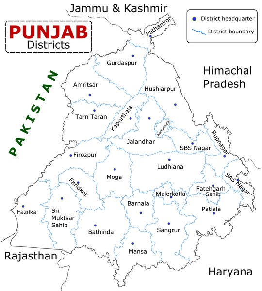
{{Information |Description=State of Punjab, India with districts marked along with district HQ. |Source=Self made using Inkscape. Source map referred from Punjab govt. site. |Date=04/26/2008 |Author=Wikigringo |Permission= |other_versions= }}
ไฟล, punjab, district, ไฟล, ประว, ไฟล, หน, าท, ภาพน, การใช, ไฟล, วนกลาง, อม, ลเก, ยวก, บภาพขนาดของต, วอย, างน, กเซล, ความละเอ, ยดอ, กเซล, กเซล, กเซล, กเซล, กเซล, ภาพท, ความละเอ, ยดส, งกว, 8206, กเซล, ขนาดไฟล, โลไบต, ชน, ดไมม, image, ปภาพหร, อไฟล, เส, ยงน, นฉบ,. ifl prawtiifl hnathimiphaphni karichiflswnklang khxmulekiywkbphaphkhnadkhxngtwxyangni 540 600 phikesl khwamlaexiydxun 216 240 phikesl 432 480 phikesl 691 768 phikesl 922 1 024 phikesl 2 467 2 741 phikesl duphaphthimikhwamlaexiydsungkwa 8206 2 467 2 741 phikesl khnadifl 635 kiolibt chnidimm image png rupphaphhruxiflesiyngni tnchbbxyuthi khxmmxns raylaexiyddanlang epnkhxkhwamthiaesdngphlcak ifltnchbbinkhxmmxns khxmmxnsepnewbistinokhrngkarsahrbekbrwbrwmsuxesri thi khunsamarthchwyid phaphaephnthirabutaaehnngni khwrcathuksrangihmepnkrafiksewketxr sungmikhxdixikhlayprakar duephimetimthikhxmmxns suxtxngkarekbkwadsahrbsarsnethsephimetim hakphaphnimiinrupaebbkrafiksewketxrxyuaelw krunaxpohldaelaaethnthiaemaebbnidwy vector version available i chuxphaphihm i aenanaepnxyangyingihtngchuxiflewketxrihmnninrupaebb Punjab district map svg aelwisaemaebb Vector version available hrux Vva sungimtxngichpharamietxr chuxphaphihmkhwamyx khaxthibayPunjab district map png English State of Punjab Indian Punjab with districts marked along with district Headquarters wnthi 26 emsayn ph s 2551aehlngthima Self made using Inkscape Source map referred from Punjab govt site phusrangsrrkh Wikigringo karxnuyatichsiththi khapheca inthanaphuthuxlikhsiththikhxngphaphhruxsuxni xnuyatihichphaphhruxsuxniphayitenguxnikhtxipni xnuyatihkhdlxk aeckcayaela hruxddaeprexksarniphayitenguxnikhkhxngsyyaxnuyatexksaresrikhxngknu run 1 2 hruxrunid nbcaknithixxkodymulnithisxftaewresri odyimmiswnidhamaekikh immikhxkhwampkhnaaelapkhlng saenakhxngsyyaxnuyatrwmxyuinswnchux syyaxnuyatexksaresrikhxngknuhttp www gnu org copyleft fdl html GFDL GNU Free Documentation License true trueThis file is licensed under the Creative Commons Attribution Share Alike 4 0 International 3 0 Unported 2 5 Generic 2 0 Generic and 1 0 Generic license khunsamarth thicaaebngpn thicathasaena aeckcay aelasngngandngklawtxip thicaeriyberiyngihm thicaddaeplngngandngklaw phayitenguxnikhtxipni aesdngthima khuntxngihekiyrtiecakhxngnganxyangehmaasm odyephimlingkipyngsyyaxnuyat aelarabuhakmikarepliynaeplng khunxacthaechnniidinrupaebbidkidtamkhwr aettxngimichinlksnathiaenawaphuihxnuyatsnbsnunkhunhruxkarichngankhxngkhun xnuyataebbediywkn hakkhunddaeplng epliynrup hruxtxetimnganni khuntxngichsyyaxnuyataebbediywknhruxaebbthiehmuxnkbsyyaxnuyatthiichkbnganniethannhttps creativecommons org licenses by sa 4 0 CC BY SA 4 0 Creative Commons Attribution Share Alike 4 0 true truekhunsamartheluxksyyaxnuyatdngklawtamtxngkarkhabrryayodyyxithyephimkhabrryaythrrthdediywephuxkhyaykhwamwaiflnimixairixethmthiaesdngxyuiniflniprakxbdwysthanalikhsiththimilikhsiththisyyaxnuyatCreative Commons Attribution ShareAlike 3 0 Unported xngkvsGNU Free Documentation License version 1 2 or later xngkvsCreative Commons Attribution ShareAlike 4 0 International xngkvsCreative Commons Attribution ShareAlike 2 0 Generic xngkvsCreative Commons Attribution ShareAlike 2 5 Generic xngkvsCreative Commons Attribution ShareAlike 1 0 Generic xngkvswnthisrang wnkxtng26 emsayn 2008MIME type xngkvsimage png prawtiifl khlikwnthi ewlaephuxduiflthipraktinkhnann wnthi ewlarupyxkhnadphuichkhwamehn pccubn16 25 10 mkrakhm 25662 467 2 741 635 kiolibt Saad Ali Khan Pakistanupdated district MalerKotla on map 11 45 7 krkdakhm 25632 467 2 741 867 kiolibt Kaushal BishnoiNew Update version of Punjab District Map with 22 District 21 41 5 tulakhm 25561 094 848 127 kiolibt Ras67cropped and optimized 15 40 28 emsayn 25511 211 874 187 kiolibt WikigringoUploading a better color version of the file with bigger font size 23 01 26 emsayn 25511 269 907 167 kiolibt Wikigringo Information Description State of Punjab India with districts marked along with district HQ Source Self made using Inkscape Source map referred from Punjab govt site Date 04 26 2008 Author Wikigringo Permission other versions hnathimiphaphni hnatxipni oyngmathiphaphni rthpycab karichiflswnklang wikixuntxipniichiflni karichbn ar wikipedia org بنجاب الهند اللغة البجرية منطقة فاريدكوت منطقة موكاتسار حركة خالصتان karichbn azb wikipedia org جهوک سارکاری karichbn bh wikipedia org प ज ब क ज ल सभ क ल स ट karichbn bn wikipedia org প ঞ জ ব র জ ল সম হ র ত ল ক ভ রত ফ জ লক জ ল ম গ জ ল karichbn ca wikipedia org Panjab India Faridkot ciutat Districte de Firozpur Districte de Gurdaspur Districte d Hoshiarpur Districte de Jalandhar karichbn ceb wikipedia org Ludhiana distrito sa Indiya Faridkot lungsod sa Indiya Muktsar distrito karichbn en wikipedia org Khalistan movement List of districts of Punjab India Moga district Bagri language Politics of Punjab India User Gppande Album Punjab India Wikipedia Graphics Lab Map workshop Archive Feb 2013 User SheriffIsInTown Bagar tract Jhok Sarkari karichbn es wikipedia org Republica Federal de Jalistan Distrito de Mukatsar Faridkot karichbn eu wikipedia org Sri Muktsar Sahib barrutia karichbn fa wikipedia org بخش های پنجاب هند karichbn fi wikipedia org Punjab Intia karichbn fr wikipedia org Pendjab Inde District de Barnala District de Faridkot District de Fatehgarh Sahib District de Fazilka District de Firozpur District de Gurdaspur District de Hoshiarpur District de Jalandhar District de Kapurthala District de Ludhiana District de Mansa Penjab District de Moga District de Mohali dukarichthwolkephimetimkhxngiflnikhxmulekiywkbphaph phaphnimikhxmulephimetim sungswnihymacakklxngdicitxlhruxsaeknenxrthisamarthekbkhxmuldngklawiwrwmkbphaphid thaphaphnithukprbprungaekikhhruxepliynaeplngcakedim khxmulbangxyangcayngkhngimepliynaeplngehmuxnphaphthithukprbprungaekikhnnkhwamlaexiydaenwnxn47 24 dpckhwamlaexiydaenwtng47 24 dpc ekhathungcak https th wikipedia org wiki ifl Punjab district map png, wikipedia, วิกิ หนังสือ, หนังสือ, ห้องสมุด,