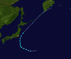
fbpx
วิกิพีเดีย

Sepat 2013 track

ดูภาพที่มีความละเอียดสูงกว่า(2,700 × 2,232 พิกเซล, ขนาดไฟล์: 1.93 เมกะไบต์, ชนิดไมม์: image/png)

รูปภาพหรือไฟล์เสียงนี้ ต้นฉบับอยู่ที่ คอมมอนส์ รายละเอียดด้านล่าง เป็นข้อความที่แสดงผลจาก ไฟล์ต้นฉบับในคอมมอนส์
คอมมอนส์เป็นเว็บไซต์ในโครงการสำหรับเก็บรวบรวมสื่อเสรี ที่ คุณสามารถช่วยได้

ความย่อ

คำอธิบาย
English: Track map of Tropical Storm Sepat of the 2013 Pacific typhoon season. The points show the location of the storm at 6-hour intervals. The colour represents the storm's maximum sustained wind speeds as classified in the Saffir–Simpson scale (see below), and the shape of the data points represent the nature of the storm, according to the legend below.

Saffir–Simpson scale

 
Tropical depression (≤38 mph, ≤62 km/h)
 
Tropical storm (39–73 mph, 63–118 km/h)
 
Category 1 (74–95 mph, 119–153 km/h)
 
Category 2 (96–110 mph, 154–177 km/h)
 
Category 3 (111–129 mph, 178–208 km/h)
 
Category 4 (130–156 mph, 209–251 km/h)
 
Category 5 (≥157 mph, ≥252 km/h)
 
Unknown

Storm type

Tropical cyclone
Subtropical cyclone
Extratropical cyclone / Remnant low / Tropical disturbance / Monsoon depression
วันที่ 2013-09-29–2013-10-03
แหล่งที่มา Created by Meow using WikiProject Tropical cyclones/Tracks. The background image is from NASA. Tracking data is from the Joint Typhoon Warning Center[1].
ผู้สร้างสรรค์ Meow
Source code
InfoField
Track map data table, if present below, is in HURDAT2 or ATCF format. See format details in [2] and [3].
Track map generator input code
WP292013, SEPAT, 19, 20130929, 0600, , DB, 26.4N, 151.5E, 20, 1002, 0, 0, 0, 0, 0, 0, 0, 0, 0, 0, 0, 0, JMA, 20130929, 1200, , DB, 26.3N, 150.0E, 20, 1002, 0, 0, 0, 0, 0, 0, 0, 0, 0, 0, 0, 0, JMA, 20130929, 1800, , TD, 26.2N, 148.1E, 25, 1002, 0, 0, 0, 0, 0, 0, 0, 0, 0, 0, 0, 0, JTWC, 20130930, 0000, , TD, 26.5N, 146.7E, 30, 1000, 0, 0, 0, 0, 0, 0, 0, 0, 0, 0, 0, 0, JTWC, 20130930, 0600, , TS, 27.2N, 145.2E, 35, 998, 65, 0, 100, 75, 0, 0, 0, 0, 0, 0, 0, 0, JTWC, 20130930, 1200, , TS, 27.8N, 143.7E, 35, 996, 65, 0, 65, 80, 0, 0, 0, 0, 0, 0, 0, 0, JTWC, 20130930, 1800, , TS, 28.5N, 142.3E, 35, 994, 65, 0, 45, 95, 0, 0, 0, 0, 0, 0, 0, 0, JTWC, 20131001, 0000, , TS, 29.1N, 141.7E, 35, 994, 65, 0, 0, 130, 0, 0, 0, 0, 0, 0, 0, 0, JTWC, 20131001, 0600, , TS, 30.2N, 141.5E, 40, 994, 55, 0, 0, 0, 0, 0, 0, 0, 0, 0, 0, 0, JTWC, 20131001, 1200, , TS, 31.3N, 141.5E, 35, 994, 80, 65, 0, 0, 0, 0, 0, 0, 0, 0, 0, 0, JTWC, 20131001, 1800, , TS, 32.6N, 141.3E, 35, 994, 80, 160, 0, 0, 0, 0, 0, 0, 0, 0, 0, 0, JTWC, 20131002, 0000, , TS, 34.0N, 141.5E, 35, 994, 105, 115, 0, 0, 0, 0, 0, 0, 0, 0, 0, 0, JTWC, 20131002, 0600, , TS, 35.6N, 142.0E, 35, 992, 120, 230, 0, 0, 0, 0, 0, 0, 0, 0, 0, 0, JTWC, 20131002, 1200, , TS, 37.5N, 143.3E, 40, 992, 215, 230, 0, 0, 0, 0, 0, 0, 0, 0, 0, 0, JTWC, 20131002, 1800, , EX, 40.5N, 145.9E, 50, 990, 260, 280, 0, 0, 0, 0, 0, 0, 0, 0, 0, 0, JTWC, 20131003, 0000, , EX, 44.0N, 149.4E, 50, 990, 185, 200, 0, 0, 0, 0, 0, 0, 0, 0, 0, 0, JTWC, 20131003, 0600, , EX, 48.4N, 153.7E, 45, 996, 0, 0, 0, 0, 0, 0, 0, 0, 0, 0, 0, 0, JMA, 20131003, 1200, , EX, 50.8N, 156.4E, 40, 1000, 0, 0, 0, 0, 0, 0, 0, 0, 0, 0, 0, 0, JMA, 20131003, 1800, , EX, 53.4N, 161.0E, 35, 1004, 0, 0, 0, 0, 0, 0, 0, 0, 0, 0, 0, 0, JMA, 

การอนุญาตใช้สิทธิ

คำบรรยายโดยย่อ

เพิ่มคำบรรยายทรรทัดเดียวเพื่อขยายความว่าไฟล์นี้มีอะไร

ไอเทมที่แสดงอยู่ในไฟล์นี้

ประกอบด้วย

สถานะลิขสิทธิ์

copyrighted, dedicated to the public domain by copyright holder อังกฤษ

สัญญาอนุญาต

released into the public domain by the copyright holder อังกฤษ

ประวัติไฟล์

คลิกวันที่/เวลาเพื่อดูไฟล์ที่ปรากฏในขณะนั้น

วันที่/เวลารูปย่อขนาดผู้ใช้ความเห็น
ปัจจุบัน13:37, 18 กันยายน 25572,700 × 2,232 (1.93 เมกะไบต์)MeowPositions fixed
10:24, 7 กันยายน 25572,700 × 2,232 (1.96 เมกะไบต์)SupportstormIBTrACS version
14:19, 9 กรกฎาคม 25572,700 × 2,232 (1.93 เมกะไบต์)MeowJTWC best track data extended with JMA best track data
00:17, 6 ตุลาคม 25562,000 × 1,640 (1.02 เมกะไบต์)SupportstormAdded extra-tropical points
14:30, 3 ตุลาคม 25562,000 × 1,236 (608 กิโลไบต์)Keith EdkinsUpdate, believed to be final
15:48, 2 ตุลาคม 25562,000 × 1,236 (375 กิโลไบต์)Keith Edkins{{current}}{{Information |Description={{en|Track map of Tropical Storm Sepat of the 2013 Pacific typhoon season. The points show the location of the storm at 6-hou...

หน้าต่อไปนี้ โยงมาที่ภาพนี้:

การใช้ไฟล์ส่วนกลาง

วิกิอื่นต่อไปนี้ใช้ไฟล์นี้:

  • User:Nino Marakot/2013 Pacific typhoon season
  • User:Tfmbty/2013 Pacific typhoon season
  • 熱帶風暴聖帕 (2013年)
  • ไฟล, sepat, 2013, track, ไฟล, ประว, ไฟล, หน, าท, ภาพน, การใช, ไฟล, วนกลางขนาดของต, วอย, างน, กเซล, ความละเอ, ยดอ, กเซล, กเซล, กเซล, กเซล, กเซล, กเซล, ภาพท, ความละเอ, ยดส, งกว, 8206, กเซล, ขนาดไฟล, เมกะไบต, ชน, ดไมม, image, ปภาพหร, อไฟล, เส, ยงน, นฉบ, บอย, คอมม. ifl prawtiifl hnathimiphaphni karichiflswnklangkhnadkhxngtwxyangni 725 599 phikesl khwamlaexiydxun 290 240 phikesl 581 480 phikesl 929 768 phikesl 1 239 1 024 phikesl 2 478 2 048 phikesl 2 700 2 232 phikesl duphaphthimikhwamlaexiydsungkwa 8206 2 700 2 232 phikesl khnadifl 1 93 emkaibt chnidimm image png rupphaphhruxiflesiyngni tnchbbxyuthi khxmmxns raylaexiyddanlang epnkhxkhwamthiaesdngphlcak ifltnchbbinkhxmmxns khxmmxnsepnewbistinokhrngkarsahrbekbrwbrwmsuxesri thi khunsamarthchwyid khwamyx khaxthibaySepat 2013 track png English Track map of Tropical Storm Sepat of the 2013 Pacific typhoon season The points show the location of the storm at 6 hour intervals The colour represents the storm s maximum sustained wind speeds as classified in the Saffir Simpson scale see below and the shape of the data points represent the nature of the storm according to the legend below Saffir Simpson scale Tropical depression 38 mph 62 km h Tropical storm 39 73 mph 63 118 km h Category 1 74 95 mph 119 153 km h Category 2 96 110 mph 154 177 km h Category 3 111 129 mph 178 208 km h Category 4 130 156 mph 209 251 km h Category 5 157 mph 252 km h Unknown Storm type Tropical cyclone Subtropical cyclone Extratropical cyclone Remnant low Tropical disturbance Monsoon depressionwnthi 2013 09 29 2013 10 03aehlngthima Created by Meow using WikiProject Tropical cyclones Tracks The background image is from NASA Tracking data is from the Joint Typhoon Warning Center 1 phusrangsrrkh MeowSource codeInfoFieldTrack map data table if present below is in HURDAT2 or ATCF format See format details in 2 and 3 Track map generator input codeWP292013 SEPAT 19 20130929 0600 DB 26 4N 151 5E 20 1002 0 0 0 0 0 0 0 0 0 0 0 0 JMA 20130929 1200 DB 26 3N 150 0E 20 1002 0 0 0 0 0 0 0 0 0 0 0 0 JMA 20130929 1800 TD 26 2N 148 1E 25 1002 0 0 0 0 0 0 0 0 0 0 0 0 JTWC 20130930 0000 TD 26 5N 146 7E 30 1000 0 0 0 0 0 0 0 0 0 0 0 0 JTWC 20130930 0600 TS 27 2N 145 2E 35 998 65 0 100 75 0 0 0 0 0 0 0 0 JTWC 20130930 1200 TS 27 8N 143 7E 35 996 65 0 65 80 0 0 0 0 0 0 0 0 JTWC 20130930 1800 TS 28 5N 142 3E 35 994 65 0 45 95 0 0 0 0 0 0 0 0 JTWC 20131001 0000 TS 29 1N 141 7E 35 994 65 0 0 130 0 0 0 0 0 0 0 0 JTWC 20131001 0600 TS 30 2N 141 5E 40 994 55 0 0 0 0 0 0 0 0 0 0 0 JTWC 20131001 1200 TS 31 3N 141 5E 35 994 80 65 0 0 0 0 0 0 0 0 0 0 JTWC 20131001 1800 TS 32 6N 141 3E 35 994 80 160 0 0 0 0 0 0 0 0 0 0 JTWC 20131002 0000 TS 34 0N 141 5E 35 994 105 115 0 0 0 0 0 0 0 0 0 0 JTWC 20131002 0600 TS 35 6N 142 0E 35 992 120 230 0 0 0 0 0 0 0 0 0 0 JTWC 20131002 1200 TS 37 5N 143 3E 40 992 215 230 0 0 0 0 0 0 0 0 0 0 JTWC 20131002 1800 EX 40 5N 145 9E 50 990 260 280 0 0 0 0 0 0 0 0 0 0 JTWC 20131003 0000 EX 44 0N 149 4E 50 990 185 200 0 0 0 0 0 0 0 0 0 0 JTWC 20131003 0600 EX 48 4N 153 7E 45 996 0 0 0 0 0 0 0 0 0 0 0 0 JMA 20131003 1200 EX 50 8N 156 4E 40 1000 0 0 0 0 0 0 0 0 0 0 0 0 JMA 20131003 1800 EX 53 4N 161 0E 35 1004 0 0 0 0 0 0 0 0 0 0 0 0 JMA karxnuyatichsiththi Public domain Public domain false falsenganniidthukephyaephrsusatharnsmbtiodyecakhxng Meow sungmiphlthwolkinbangpraeths karkrathadngklawxacimsamarththaidtamkdhmayMeow xnuyatihthukkhnmisiththiinkarichiflniinthukehtuphlkarich odyimmimienguxnikh ewnaetkdhmayimxnuyatihthaechnnnkhabrryayodyyxithyephimkhabrryaythrrthdediywephuxkhyaykhwamwaiflnimixairixethmthiaesdngxyuiniflniprakxbdwysthanalikhsiththicopyrighted dedicated to the public domain by copyright holder xngkvssyyaxnuyatreleased into the public domain by the copyright holder xngkvs prawtiifl khlikwnthi ewlaephuxduiflthipraktinkhnann wnthi ewlarupyxkhnadphuichkhwamehn pccubn13 37 18 knyayn 25572 700 2 232 1 93 emkaibt MeowPositions fixed 10 24 7 knyayn 25572 700 2 232 1 96 emkaibt SupportstormIBTrACS version 14 19 9 krkdakhm 25572 700 2 232 1 93 emkaibt MeowJTWC best track data extended with JMA best track data 00 17 6 tulakhm 25562 000 1 640 1 02 emkaibt SupportstormAdded extra tropical points 14 30 3 tulakhm 25562 000 1 236 608 kiolibt Keith EdkinsUpdate believed to be final 15 48 2 tulakhm 25562 000 1 236 375 kiolibt Keith Edkins current Information Description en Track map of Tropical Storm Sepat of the 2013 Pacific typhoon season The points show the location of the storm at 6 hou hnathimiphaphni hnatxipni oyngmathiphaphni vduphayuitfunaepsifik ph s 2556 karichiflswnklang wikixuntxipniichiflni karichbn de wikipedia org Pazifische Taifunsaison 2013 karichbn en wikipedia org 2013 Pacific typhoon season User Nino Marakot 2013 Pacific typhoon season User Tfmbty 2013 Pacific typhoon season karichbn es wikipedia org Temporada de tifones en el Pacifico de 2013 karichbn fr wikipedia org Saison cyclonique 2013 dans l ocean Pacifique nord ouest karichbn ja wikipedia org 2013年の台風 karichbn ko wikipedia org 2013년 태풍 karichbn pt wikipedia org Temporada de tufoes no Pacifico de 2013 karichbn simple wikipedia org 2013 Pacific typhoon season karichbn tl wikipedia org Panahon ng bagyo sa Pasipiko ng 2013 karichbn vi wikipedia org Mua bao Tay Bắc Thai Binh Dương 2013 karichbn zh yue wikipedia org 2013年太平洋颱風季 karichbn zh wikipedia org 2013年太平洋颱風季 熱帶風暴聖帕 2013年 ekhathungcak https th wikipedia org wiki ifl Sepat 2013 track png, wikipedia, วิกิ หนังสือ, หนังสือ, ห้องสมุด,

    บทความ

    , อ่าน, ดาวน์โหลด, ฟรี, ดาวน์โหลดฟรี, mp3, วิดีโอ, mp4, 3gp, jpg, jpeg, gif, png, รูปภาพ, เพลง, เพลง, หนัง, หนังสือ, เกม, เกม