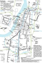
Deutsch: Gleisplan der Straßenbahn Kolkata (Oktober 2004)
English: Streetcar Track Layout (October 2004) – note logo
Author: Maximilian Dörrbecker (Chumwa)
Source: self made
Date of creation: October 2004
This image was uploaded in the JPEG format even though it consists of non-photographic data. This information could be stored more efficiently or accurately in the PNG or SVG format. If possible, please upload a PNG or SVG version of this image without compression artifacts, derived from a non-JPEG source (or with existing artifacts removed). After doing so, please tag the JPEG version with {{Superseded|NewImage.ext}} and remove this tag. This tag should not be applied to photographs or scans. For more information, see {{BadJPEG}}.
ภาพแผนที่การขนส่งนี้ ควรจะถูกสร้างใหม่เป็นกราฟิกส์เวกเตอร์ ซึ่งมีข้อดีอีกหลายประการ ดูเพิ่มเติมที่คอมมอนส์:สื่อต้องการเก็บกวาดสำหรับสารสนเทศเพิ่มเติม หากภาพนี้มีในรูปแบบกราฟิกส์เวกเตอร์อยู่แล้ว กรุณาอัปโหลดและแทนที่แม่แบบนี้ด้วย {{vector version available|ชื่อภาพใหม่}} แนะนำเป็นอย่างยิ่งให้ตั้งชื่อไฟล์เวกเตอร์ใหม่นั้นในรูปแบบ "StraßenbahngleisplanKolkataOktober2004.svg" แล้วใส่แม่แบบ Vector version available (หรือ Vva) ซึ่งไม่ต้องใช้พารามิเตอร์ ชื่อภาพใหม่
This transport map image was uploaded in the JPEG format even though it consists of non-photographic data. This information could be stored more efficiently or accurately in the PNG or SVG format. If possible, please upload a PNG or SVG version of this image without compression artifacts, derived from a non-JPEG source (or with existing artifacts removed). After doing so, please tag the JPEG version with {{Superseded|NewImage.ext}} and remove this tag. This tag should not be applied to photographs or scans. For more information, see {{BadJPEG}}.
Need Assistance!
I don't live in India and the map basically was drawn after a journey of the Kolkata tramway network in October 2004. I would like to update the plan in the future, but the informations given in the media and the Web about system extensions are often incorrect or very inaccurate. So if you want the network map as accurate as possible too, please announce your error hints and corrections about the correct network configuration on my German discussion page.
*Description: *:{{deutsch}} Straßenbahngleisplan Kolkata im Oktober 2004 *Source: own drawing, Okt. 2004 *Illustrator: Maximilian Dörbecker Categorie:Public Transport
ไฟล, straßenbahngleisplankolkataoktober2004, ไฟล, ประว, ไฟล, หน, าท, ภาพน, การใช, ไฟล, วนกลาง, อม, ลเก, ยวก, บภาพขนาดของต, วอย, างน, กเซล, ความละเอ, ยดอ, กเซล, กเซล, กเซล, ภาพท, ความละเอ, ยดส, งกว, 8206, กเซล, ขนาดไฟล, โลไบต, ชน, ดไมม, image, jpeg, ปภาพหร, อไฟ. ifl prawtiifl hnathimiphaphni karichiflswnklang khxmulekiywkbphaphkhnadkhxngtwxyangni 406 599 phikesl khwamlaexiydxun 162 240 phikesl 325 480 phikesl 867 1 280 phikesl duphaphthimikhwamlaexiydsungkwa 8206 867 1 280 phikesl khnadifl 317 kiolibt chnidimm image jpeg rupphaphhruxiflesiyngni tnchbbxyuthi khxmmxns raylaexiyddanlang epnkhxkhwamthiaesdngphlcak ifltnchbbinkhxmmxns khxmmxnsepnewbistinokhrngkarsahrbekbrwbrwmsuxesri thi khunsamarthchwyid khwamyx Description Deutsch Gleisplan der Strassenbahn Kolkata Oktober 2004 English Streetcar Track Layout October 2004 note logoAuthor Maximilian Dorrbecker Chumwa Source self made Date of creation October 2004 This image was uploaded in the JPEG format even though it consists of non photographic data This information could be stored more efficiently or accurately in the PNG or SVG format If possible please upload a PNG or SVG version of this image without compression artifacts derived from a non JPEG source or with existing artifacts removed After doing so please tag the JPEG version with Superseded NewImage ext and remove this tag This tag should not be applied to photographs or scans For more information see BadJPEG phaphaephnthikarkhnsngni khwrcathuksrangihmepnkrafiksewketxr sungmikhxdixikhlayprakar duephimetimthikhxmmxns suxtxngkarekbkwadsahrbsarsnethsephimetim hakphaphnimiinrupaebbkrafiksewketxrxyuaelw krunaxpohldaelaaethnthiaemaebbnidwy vector version available i chuxphaphihm i aenanaepnxyangyingihtngchuxiflewketxrihmnninrupaebb StrassenbahngleisplanKolkataOktober2004 svg aelwisaemaebb Vector version available hrux Vva sungimtxngichpharamietxr chuxphaphihmThis transport map image was uploaded in the JPEG format even though it consists of non photographic data This information could be stored more efficiently or accurately in the PNG or SVG format If possible please upload a PNG or SVG version of this image without compression artifacts derived from a non JPEG source or with existing artifacts removed After doing so please tag the JPEG version with Superseded NewImage ext and remove this tag This tag should not be applied to photographs or scans For more information see BadJPEG Need Assistance I don t live in India and the map basically was drawn after a journey of the Kolkata tramway network in October 2004 I would like to update the plan in the future but the informations given in the media and the Web about system extensions are often incorrect or very inaccurate So if you want the network map as accurate as possible too please announce your error hints and corrections about the correct network configuration on my German discussion page Thank you in advance karxnuyatichsiththi khapheca inthanaphuthuxlikhsiththikhxngphaphhruxsuxni xnuyatihichphaphhruxsuxniphayitenguxnikhtxipniiflnixyuphayitsyyaxnuyat khriexthifkhxmmxns aebbaesdngthima xnuyataebbediywkn 2 5 thwipkhunsamarth thicaaebngpn thicathasaena aeckcay aelasngngandngklawtxip thicaeriyberiyngihm thicaddaeplngngandngklaw phayitenguxnikhtxipni aesdngthima khuntxngihekiyrtiecakhxngnganxyangehmaasm odyephimlingkipyngsyyaxnuyat aelarabuhakmikarepliynaeplng khunxacthaechnniidinrupaebbidkidtamkhwr aettxngimichinlksnathiaenawaphuihxnuyatsnbsnunkhunhruxkarichngankhxngkhun xnuyataebbediywkn hakkhunddaeplng epliynrup hruxtxetimnganni khuntxngichsyyaxnuyataebbediywknhruxaebbthiehmuxnkbsyyaxnuyatthiichkbnganniethannhttps creativecommons org licenses by sa 2 5 CC BY SA 2 5 Creative Commons Attribution Share Alike 2 5 true truekhabrryayodyyxithyephimkhabrryaythrrthdediywephuxkhyaykhwamwaiflnimixairixethmthiaesdngxyuiniflniprakxbdwysthanalikhsiththimilikhsiththisyyaxnuyatCreative Commons Attribution ShareAlike 2 5 Generic xngkvs prawtiifl khlikwnthi ewlaephuxduiflthipraktinkhnann wnthi ewlarupyxkhnadphuichkhwamehn pccubn15 15 16 krkdakhm 2548867 1 280 317 kiolibt Norro Description deutsch Strassenbahngleisplan Kolkata im Oktober 2004 Source own drawing Okt 2004 Illustrator Maximilian Dorbecker Categorie Public Transport hnathimiphaphni hnatxipni oyngmathiphaphni rthranginoklkata karichiflswnklang wikixuntxipniichiflni karichbn bn wikipedia org ক য লক ট ট র মওয জ ক ম প ন karichbn de wikipedia org Kalkutta Benutzer Chumwa Benutzer Chumwa SomeOfMyFiles karichbn hi wikipedia org क लक त क लक त म ट र karichbn sv wikipedia org Calcuttas tunnelbana karichbn zh wikipedia org 加尔各答khxmulekiywkbphaph phaphnimikhxmulephimetim sungswnihymacakklxngdicitxlhruxsaeknenxrthisamarthekbkhxmuldngklawiwrwmkbphaphid thaphaphnithukprbprungaekikhhruxepliynaeplngcakedim khxmulbangxyangcayngkhngimepliynaeplngehmuxnphaphthithukprbprungaekikhnnkarcdwangphaphpktikhwamlaexiydaenwnxn299 dpikhwamlaexiydaenwtng299 dpisxftaewrthiichAdobe Photoshop CS Windowsaekikhphaphlasud23 47 14 krkdakhm 2548sepssisRGB ekhathungcak https th wikipedia org wiki ifl StrassenbahngleisplanKolkataOktober2004 jpg, wikipedia, วิกิ หนังสือ, หนังสือ, ห้องสมุด,