富士山防災協議会 (Mt. Fuji Disaster Prevention Council); Miya.m added the URL and the information to the Map and uploaded under the permission of the Cabinet Office of the Japanese Government
การอนุญาต (การใช้ไฟล์นี้ใหม่)
This work is licensed under the Government of Japan Standard Terms of Use (Ver.2.0). The Terms of Use are compatible with the Creative Commons Attribution License 4.0 International. For terms of use this work, see this license page.
English ∙ español ∙ македонски ∙ 한국어 ∙ 日本語 ∙ 中文(简体) ∙ 中文(繁體) ∙ +/−
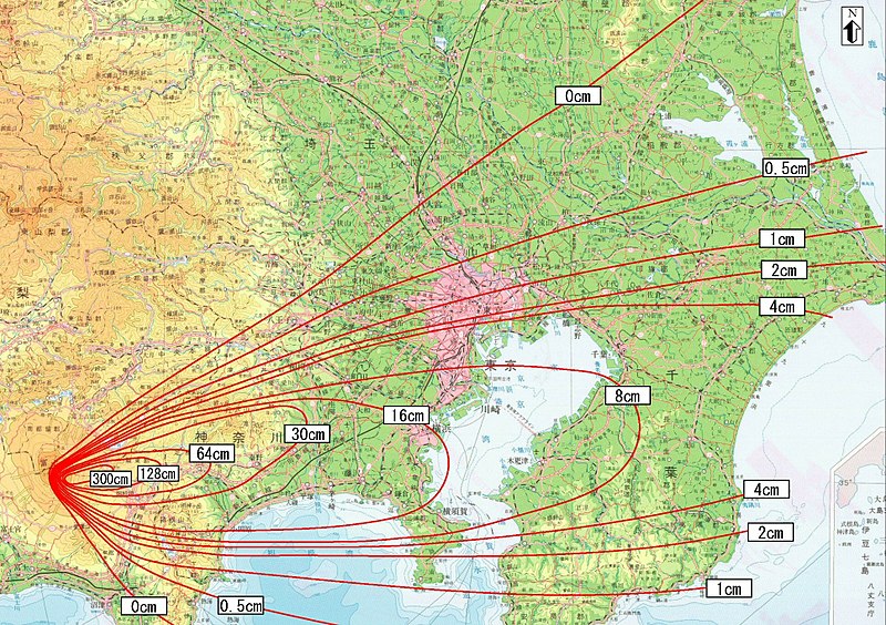
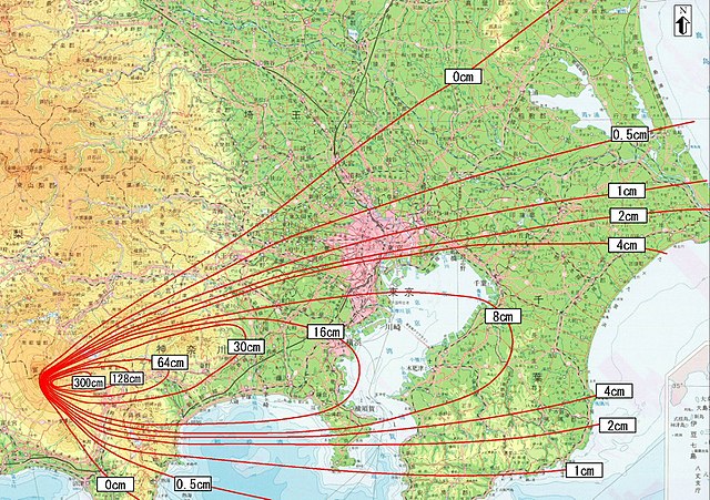
{{Information| |Description = 富士山宝永噴火降灰分布実績図(The result map of the volcanic ashes downfall of Mt.Fuji's Hoei-eruption |Source =出典:富士山防災協議会(Mt.Fuji anti-disaster conference) http://www.bousai.go.jp/fuji
ไฟล, volcanic, downfall, fuji, hoei, eruption01, ไฟล, ประว, ไฟล, หน, าท, ภาพน, การใช, ไฟล, วนกลางขนาดของต, วอย, างน, กเซล, ความละเอ, ยดอ, กเซล, กเซล, กเซล, กเซล, กเซล, ภาพท, ความละเอ, ยดส, งกว, 8206, กเซล, ขนาดไฟล, เมกะไบต, ชน, ดไมม, image, jpeg, ปภาพหร, อไฟล,. ifl prawtiifl hnathimiphaphni karichiflswnklangkhnadkhxngtwxyangni 800 564 phikesl khwamlaexiydxun 320 226 phikesl 640 451 phikesl 1 024 722 phikesl 1 280 902 phikesl 1 935 1 364 phikesl duphaphthimikhwamlaexiydsungkwa 8206 1 935 1 364 phikesl khnadifl 1 54 emkaibt chnidimm image jpeg rupphaphhruxiflesiyngni tnchbbxyuthi khxmmxns raylaexiyddanlang epnkhxkhwamthiaesdngphlcak ifltnchbbinkhxmmxns khxmmxnsepnewbistinokhrngkarsahrbekbrwbrwmsuxesri thi khunsamarthchwyid khwamyx khaxthibayVolcanic ash downfall map of Mt Fuji Hoei eruption01 jpg 日本語 防災対応を検討するための降灰分布図 富士山宝永噴火 English Ashfall distribution map for examining disaster prevention measures Mt Fuji Hoei eruption wnthi 中間報告 平成14年6月12日 the interim report was released on 2002 6 12 aehlngthima 日本語 富士山ハザードマップ検討委員会中間報告 English Mt Fuji Hazard Map Review Committee Interim Report http www bousai go jp fujisan h map kentou interim report http www bousai go jp fujisan h map kentou interim report all p pdf 出典 富士山防災協議会 the Mt Fuji Volcano Disaster Management Conference phusrangsrrkh 富士山防災協議会 Mt Fuji Disaster Prevention Council Miya m added the URL and the information to the Map and uploaded under the permission of the Cabinet Office of the Japanese Governmentkarxnuyat karichiflniihm This work is licensed under the Government of Japan Standard Terms of Use Ver 2 0 The Terms of Use are compatible with the Creative Commons Attribution License 4 0 International For terms of use this work see this license page English espanol makedonski 한국어 日本語 中文 简体 中文 繁體 iflnixyuphayitsyyaxnuyatkhriexthifkhxmmxns run aesdngthima 4 0 nanachatikaraesdngthima 内閣府防災のページkhunsamarth thicaaebngpn thicathasaena aeckcay aelasngngandngklawtxip thicaeriyberiyngihm thicaddaeplngngandngklaw phayitenguxnikhtxipni aesdngthima khuntxngihekiyrtiecakhxngnganxyangehmaasm odyephimlingkipyngsyyaxnuyat aelarabuhakmikarepliynaeplng khunxacthaechnniidinrupaebbidkidtamkhwr aettxngimichinlksnathiaenawaphuihxnuyatsnbsnunkhunhruxkarichngankhxngkhunhttps creativecommons org licenses by 4 0 CC BY 4 0 Creative Commons Attribution 4 0 true trueewxrchnxun Image Hazard Map of Mt Fuji common l jpg karxnuyatichsiththi work of the Mt Fuji Volcano Disaster Management Conference http www bousai go jp fujisan kyougikai supported by Japanese government cabinet officials http www bousai go jp confirmed to be CC by 4 0 cf 1 iflnixyuphayitsyyaxnuyatkhriexthifkhxmmxns run aesdngthima 4 0 nanachatikhunsamarth thicaaebngpn thicathasaena aeckcay aelasngngandngklawtxip thicaeriyberiyngihm thicaddaeplngngandngklaw phayitenguxnikhtxipni aesdngthima khuntxngihekiyrtiecakhxngnganxyangehmaasm odyephimlingkipyngsyyaxnuyat aelarabuhakmikarepliynaeplng khunxacthaechnniidinrupaebbidkidtamkhwr aettxngimichinlksnathiaenawaphuihxnuyatsnbsnunkhunhruxkarichngankhxngkhunhttps creativecommons org licenses by 4 0 CC BY 4 0 Creative Commons Attribution 4 0 true true khabrryayodyyxithyephimkhabrryaythrrthdediywephuxkhyaykhwamwaiflnimixairixethmthiaesdngxyuiniflniprakxbdwysthanalikhsiththimilikhsiththisyyaxnuyatCreative Commons Attribution 2 5 Generic xngkvs prawtiifl khlikwnthi ewlaephuxduiflthipraktinkhnann wnthi ewlarupyxkhnadphuichkhwamehn pccubn13 38 18 thnwakhm 25601 935 1 364 1 54 emkaibt ديفيد عادل وهبة خليل 2Removed border by cropping 3 horizontally and 12 vertically using CropTool with precise mode 23 45 21 minakhm 25492 000 1 550 1 79 emkaibt Miya m Information Description 富士山宝永噴火降灰分布実績図 The result map of the volcanic ashes downfall of Mt Fuji 039 s Hoei eruption Source 出典 富士山防災協議会 Mt Fuji anti disaster conference http www bousai go jp fuji hnathimiphaphni hnatxipni oyngmathiphaphni karpathukhxngphuekhaiffuci piohex karichiflswnklang wikixuntxipniichiflni karichbn ast wikipedia org Monte Fuji karichbn ca wikipedia org Mont Fuji Erupcio Hōei del Mont Fuji karichbn cs wikipedia org Sopka Erupce Hoei hory Fudzi Sopecny spad karichbn da wikipedia org Fujis udbrud 1707 karichbn de wikipedia org Hōei Ausbruch 1707 karichbn en wikipedia org Hōei Hōei eruption karichbn es wikipedia org Monte Fuji Erupcion del monte Fuji de la era Hōei Erupciones historicas del Monte Fuji karichbn eu wikipedia org Fuji mendiaren Hōei erupzioa karichbn fa wikipedia org آتشفشان هوئی karichbn fr wikipedia org Mont Fuji Eruption du mont Fuji de l ere Hōei karichbn he wikipedia org התפרצות הואי של הר פוג י karichbn hu wikipedia org A Fudzsi kitorese a Hoei korszakban karichbn id wikipedia org Letusan Hōei karichbn it wikipedia org Eruzione Hōei del monte Fuji karichbn ja wikipedia org 宝永大噴火 karichbn ko wikipedia org 호에이 대분화 karichbn pt wikipedia org Erupcao do Monte Fuji de 1707 karichbn ru wikipedia org Velikoe izverzhenie godov Hoej karichbn simple wikipedia org Hōei eruption karichbn sl wikipedia org Izbruh Hoei karichbn sr wikipedia org Hoei karichbn sv wikipedia org Fujis utbrott under Hōei eran karichbn tr wikipedia org Hōei patlamasi karichbn www wikidata org Q288045 karichbn zh wikipedia org 宝永大喷发 ekhathungcak https th wikipedia org wiki ifl Volcanic ash downfall map of Mt Fuji Hoei eruption01 jpg, wikipedia, วิกิ หนังสือ, หนังสือ, ห้องสมุด,