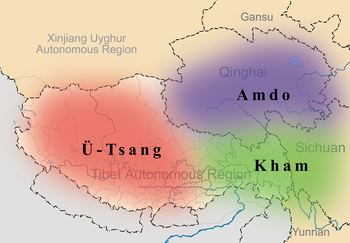
English: A simple map of the three traditional provinces of Tibet overlaid on a map of modern provincial boundaries of the People's Republic of China.
วันที่
(UTC)
แหล่งที่มา
Tibet&neighbors_Locator_map.svg
Map_of_Tibet_Ü-Tsang_Amdo_and_Kham.jpg
ผู้สร้างสรรค์
Tibet&neighbors_Locator_map.svg: Keithonearth
Map_of_Tibet_Ü-Tsang_Amdo_and_Kham.jpg: Gruschke
derivative work: Kmusser (talk)
ภาพนี้ ได้รับการปรับแต่งภาพ ซึ่งหมายความว่าจะได้รับการเปลี่ยนแปลงภาพต่างจากต้นฉบับ การปรับปรุง: added traditional provinces overlay. ต้นฉบับสามารถดูได้ที่นี่: Map of Tibet Ü-Tsang Amdo and Kham.jpg. ปรับแต่งภาพโดย Kmusser.
This image is a derivative work of the following images:
File:Tibet&neighbors_Locator_map.svg licensed with Cc-by-sa-3.0, GFDL
2009-10-13T22:22:54Z Keithonearth 1520x1059 (188220 Bytes) {{Information |Description={{en|1=A simple map of the Tibetan Autonomous Region, and surrounding Nations, and States. It was made for [[:en:Template:Location map China Tibet]].}} |Source={{own}} |Author=[[User:Keithonearth|K
File:Map_of_Tibet_Ü-Tsang_Amdo_and_Kham.jpg licensed with Cc-by-sa-2.5
{{Information |Description={{en|1=A simple map of the three traditional provinces of Tibet overlaid on a map of modern provincial boundaries of the People's Republic of China.}} == |Source=*File:Tibet&neighbors_Locator_map.svg *[[:File:Map_of_Tibet_
ไฟล, tibet, provinces, ไฟล, ประว, ไฟล, หน, าท, ภาพน, การใช, ไฟล, วนกลางขนาดของต, วอย, างน, กเซล, ความละเอ, ยดอ, กเซล, กเซล, กเซล, กเซล, ภาพท, ความละเอ, ยดส, งกว, 8206, กเซล, ขนาดไฟล, โลไบต, ชน, ดไมม, image, ปภาพหร, อไฟล, เส, ยงน, นฉบ, บอย, คอมมอนส, รายละเอ, ยด. ifl prawtiifl hnathimiphaphni karichiflswnklangkhnadkhxngtwxyangni 800 555 phikesl khwamlaexiydxun 320 222 phikesl 640 444 phikesl 1 024 711 phikesl 1 421 986 phikesl duphaphthimikhwamlaexiydsungkwa 8206 1 421 986 phikesl khnadifl 871 kiolibt chnidimm image png rupphaphhruxiflesiyngni tnchbbxyuthi khxmmxns raylaexiyddanlang epnkhxkhwamthiaesdngphlcak ifltnchbbinkhxmmxns khxmmxnsepnewbistinokhrngkarsahrbekbrwbrwmsuxesri thi khunsamarthchwyid khaxthibayTibet provinces png English A simple map of the three traditional provinces of Tibet overlaid on a map of modern provincial boundaries of the People s Republic of China wnthi 27 minakhm ph s 2554 21 32 UTC aehlngthima Tibet amp neighbors Locator map svg Map of Tibet U Tsang Amdo and Kham jpgphusrangsrrkh Tibet amp neighbors Locator map svg Keithonearth Map of Tibet U Tsang Amdo and Kham jpg Gruschke derivative work Kmusser talk phaphni idrbkarprbaetngphaph sunghmaykhwamwacaidrbkarepliynaeplngphaphtangcaktnchbb karprbprung added traditional provinces overlay tnchbbsamarthduidthini Map of Tibet U Tsang Amdo and Kham jpg prbaetngphaphody Kmusser iflnixyuphayitsyyaxnuyat khriexthifkhxmmxns aebbaesdngthima xnuyataebbediywkn 3 0 tnchbbkhunsamarth thicaaebngpn thicathasaena aeckcay aelasngngandngklawtxip thicaeriyberiyngihm thicaddaeplngngandngklaw phayitenguxnikhtxipni aesdngthima khuntxngihekiyrtiecakhxngnganxyangehmaasm odyephimlingkipyngsyyaxnuyat aelarabuhakmikarepliynaeplng khunxacthaechnniidinrupaebbidkidtamkhwr aettxngimichinlksnathiaenawaphuihxnuyatsnbsnunkhunhruxkarichngankhxngkhun xnuyataebbediywkn hakkhunddaeplng epliynrup hruxtxetimnganni khuntxngichsyyaxnuyataebbediywknhruxaebbthiehmuxnkbsyyaxnuyatthiichkbnganniethannhttps creativecommons org licenses by sa 3 0 CC BY SA 3 0 Creative Commons Attribution Share Alike 3 0 true true bnthukkarxphohld This image is a derivative work of the following images File Tibet amp neighbors Locator map svg licensed with Cc by sa 3 0 GFDL 2009 10 13T22 22 54Z Keithonearth 1520x1059 188220 Bytes Information Description en 1 A simple map of the Tibetan Autonomous Region and surrounding Nations and States It was made for en Template Location map China Tibet Source own Author User Keithonearth KFile Map of Tibet U Tsang Amdo and Kham jpg licensed with Cc by sa 2 5 2010 07 19T23 19 31Z Beao 295x187 25812 Bytes Removed border 2006 12 07T09 13 20Z Gruschke 300x192 26704 Bytes Lage der osttibetischen Regionen Amdo und Kham Karte A Gruschke Freiburg Uploaded with derivativeFXkhabrryayodyyxithyephimkhabrryaythrrthdediywephuxkhyaykhwamwaiflnimixairixethmthiaesdngxyuiniflniprakxbdwysthanalikhsiththimilikhsiththisyyaxnuyatCreative Commons Attribution ShareAlike 3 0 Unported xngkvswnthisrang wnkxtng27 minakhm 2011MIME type xngkvsimage png prawtiifl khlikwnthi ewlaephuxduiflthipraktinkhnann wnthi ewlarupyxkhnadphuichkhwamehn pccubn04 35 28 minakhm 25541 421 986 871 kiolibt Kmusser Information Description en 1 A simple map of the three traditional provinces of Tibet overlaid on a map of modern provincial boundaries of the People 039 s Republic of China Source File Tibet amp neighbors Locator map svg File Map of Tibet hnathimiphaphni hnatxipni oyngmathiphaphni klumphasathiebt khm xmot karichiflswnklang wikixuntxipniichiflni karichbn ast wikipedia org Llingues tibetanes Reinu del Tibet karichbn bg wikipedia org Amdo karichbn bn wikipedia org ত ব বত ভ ষ সম হ karichbn cdo wikipedia org Caung ngṳ karichbn cs wikipedia org Kham karichbn da wikipedia org Kinas annektering af Tibet karichbn de wikipedia org Dokham karichbn diq wikipedia org Ziwane Tibetki karichbn en wikipedia org Tibet Tibetic languages User Kmusser Images Etymology of Tibet Wikipedia Graphics Lab Map workshop Archive Mar 2011 User Tisquesusa sandbox9 karichbn en wikivoyage org Tibetan Empire karichbn en wiktionary org Kham U Tsang Amdo karichbn eo wikipedia org Amdo karichbn es wikipedia org Kham Amdo U Tsang Reino del Tibet Lenguas tibeticas karichbn et wikipedia org Tiibet Amdo karichbn eu wikipedia org Amdo karichbn fa wikipedia org تبت زبان های تبتی karichbn fr wikipedia org Tibet Amdo Discussion U Tsang Definitions du Tibet Discussion Projet Tibet Utilisateur Redacteur Tibet Brouillon Revolte en Amdo en 1958 Tibetain du Kham karichbn fr wiktionary org Amdo Kham karichbn ga wikipedia org Amdo karichbn hi wikipedia org इउ त स ग अम द खम त ब बत ई भ ष ए karichbn hu wikipedia org Amdo Tibeti nyelvek Kozep tibeti nyelv Khami tibeti nyelv Amdoi tibeti nyelv dukarichthwolkephimetimkhxngiflni ekhathungcak https th wikipedia org wiki ifl Tibet provinces png, wikipedia, วิกิ หนังสือ, หนังสือ, ห้องสมุด,